Open-File Report 2014–1018
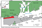
The U.S. Geological Survey (USGS) is working in cooperation with the National Oceanic and Atmospheric Administration (NOAA) to study the sea floor along the northeast coast of the United States, specifically along the coasts of New York, Connecticut, Rhode Island, and Massachusetts. Multibeam-echosounder (MBES) and sidescan-sonar data, collected by NOAA to update hydrographic charts, can be used along with sediment samples and still and video photography of the sea floor, collected by the USGS, to interpret the sea-floor features and sedimentary environments. The present study area is based on NOAA hydrographic survey H12296 in northwestern Block Island Sound, and covers 69 square kilometers (km²) of the sea floor offshore of Rhode Island from Watch Hill to Green Hill (fig. 1). The purpose of this report is (1) to interpret and delineate the features and sediments on the sea floor, and (2) to make the compiled MBES, sidescan-sonar, sediment, and photographic data available to the public. These datasets also serve as base maps for resource management and benthic studies. |

![]() U.S. Department of the Interior |
U.S. Geological Survey
U.S. Department of the Interior |
U.S. Geological Survey
URL: http://pubsdata.usgs.gov/pubs/of/2014/1018/html/intro.html
Page Contact Information: GS Pubs Web Contact
Page Last Modified: Wednesday, 07-Dec-2016 19:34:05 EST