Open-File Report 2014–1018
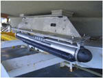
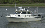
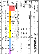
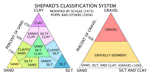
MBES and sidescan-sonar data were collected aboard the NOAA ship Thomas Jefferson (fig. 3) and aboard two of its survey launches, 3101 and 3102 (fig. 4). RESON SeaBat 7125 MBES (fig. 5), with a frequency of 400 kilohertz (kHz), were used to collect MBES data on the Thomas Jefferson and both survey launches. Sidescan-sonar data were collected using Klein 5000 systems (fig. 6), with a frequency of 455 kHz, on the survey launches. Sounding data are referenced to mean lower low water level and were corrected for tides using National Water Level Observation Network stations in Newport, R.I., New London, Connecticut, and Montauk, New York. Horizontal positioning was determined using differential global positioning system (DGPS) equipment with corrections from U.S. Coast Guard DGPS stations in Moriches, N.Y., and Acushnet, Massachusetts. Neither MBES nor sidescan-sonar data cover the entire study area; some locations have large gaps between lines and others have no data collection. MBES data were acquired using Hypack 2009 software and converted to CARIS data format by NOAA. A swath bathymetry adjusted for statistical error (BASE) surface was created in CARIS by USGS, which was interpolated to fill in small gaps (less than 10 meters (m) wide) in the data. Esri grids and GeoTIFFS were exported from CARIS. Sidescan-sonar data were acquired using Klein SonarPro software, and processed using CARIS SIPS to apply slant-range and beam-pattern corrections, and create a mosaic with 1-m resolution. More detailed information on the data acquisition and processing for this survey is provided in National Oceanic and Atmospheric Administration (2011a, b) and in the metadata files located in the Geographic Information System Data Catalog section of this report. Sediment samples and bottom photography were collected aboard the research vessel (RV) Rafael (fig. 7) during USGS cruise 2012-002-FA in June 2012. Sediment samples were obtained using a small Seabed Observation and Sampling System (SEABOSS)—a Van Veen grab with still and video cameras attached (fig. 8). Sediment samples were taken from the top 2 centimeters (cm) of the sea floor and were analyzed for grain size at the USGS Woods Hole Coastal and Marine Science Center’s Sediment Lab following the procedures outlined in Poppe and others (2005). Coarse fractions (diameters equal to or greater than 0.0625 millimeters (mm)) of the samples were analyzed with sieves, whereas the fine fractions (diameters less than 0.0625 mm) were analyzed with a Coulter Counter. Gravel-sized shells were removed from the samples because they are not considered to be representative of the sedimentary environment since they often form in situ and, hydraulically, they do not behave in the same manner as similarly sized sediment. Sediment descriptions are based on the modified nomenclature of Wentworth (1922; fig. 9) and modified size classifications of Shepard (1954; fig. 10). At each station, the SEABOSS drifted over the sea floor for several minutes while bottom video was recorded and 3 to 7 still photographs were simultaneously taken along the transect at the discretion of the operator. Photographs were taken with a Canon G12 digital camera from an optimal height of about 60 cm above the sea floor, resulting in images showing 30-cm to 1-m widths of the sea floor. Images of the still photographs can be viewed in the Bottom Photography section of this report, and full-resolution images and photograph location data are available in the Geographic Information System Data Catalog section of this report. Interpretations presented in this report are based on bathymetric, sidescan-sonar, sediment, and photographic data. Bedforms are characterized on the basis of morphology and height. Sand waves are higher than 1 m; megaripples are 0.2 to 1 m high; ripples are less than 0.2 m high (Ashley, 1990). Bathymetric data are not to be used for navigation. |

![]() U.S. Department of the Interior |
U.S. Geological Survey
U.S. Department of the Interior |
U.S. Geological Survey
URL: http://pubsdata.usgs.gov/pubs/of/2014/1018/html/methods.html
Page Contact Information: GS Pubs Web Contact
Page Last Modified: Wednesday, 07-Dec-2016 19:34:04 EST