 |
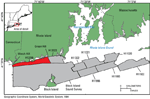
Figure 1. Map showing the location of National Oceanic and Atmospheric Administration (NOAA) survey H12296 (red-shaded polygon) offshore of Rhode Island. Also shown are other NOAA surveys (gray-shaded polygons) that have been interpreted in this series in Rhode Island and Block Island Sounds including H11320 (McMullen and others, 2007), H11321 (McMullen and others, 2008), H11322 (McMullen and others, 2009), H11922 (Poppe and others, 2011), H11995 (McMullen and others, 2012), H11996 (McMullen and others, 2011), H12023 (McMullen and others, 2013) and Block Island Sound survey, a combination of surveys H12009, H12010, H12011, H12015, H12033, H12137, and H12139 (Poppe and others, 2012). |
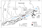 |
Figure 2. Map of end moraines (black-shaded polygons) and submerged ridges (dashed lines) in southern New York and New England (modified from Gustavson and Boothroyd, 1987) with the study area (red-outline polygon). The Ronkonkoma-Block Island-Nantucket terminal moraine represents the maximum advance of the Laurentide Ice Sheet about 20,000 to 28,000 years ago. The Harbor Hill-Roanoke Point-Charlestown-Buzzards Bay end moraine represents a retreated ice-sheet position from about 18,000 to 23,000 years ago (Uchupi and others, 2001; Balco, 2011). |
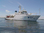 |
Figure 3. Photograph of the National Oceanic and Atmospheric Administration ship Thomas Jefferson, which collected bathymetric data in the study area. |
 |
Figure 4. Photograph of National Oceanic and Atmospheric Administration survey launch 3102, one of two launches used in the study area to collect bathymetric and sidescan-sonar data. |
 |
Figure 5. Photograph of the RESON SeaBat 7125 multibeam echosounder transducer used to collect bathymetric data in the study area. |
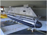 |
Figure 6. Photograph of the Klein 5000 sidescan-sonar system hull-mounted on a survey launch. |
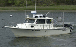 |
Figure 7. Photograph of the U.S. Geological Survey research vessel (RV) Rafael used to collect bottom photography and sediment samples in the study area. |
 |
Figure 8. Photograph of the small Seabed Observation and Sampling System (SEABOSS), a modified Van Veen grab sampler with attached video and still cameras. The SEABOSS is deployed from the aft starboard side of the U.S. Geological Survey research vessel Rafael with the use of a winch, mounted on a davit (left) and a take-up reel for the video-signal and power cable (right). |
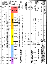 |
Figure 9. Chart showing the relations among phi sizes, millimeter diameters, size classifications (Wentworth, 1922), and American Society for Testing and Materials and Tyler sieve sizes. Chart also shows the corresponding intermediate diameters, grains per milligram, settling velocities, and threshold velocities for traction. Abbreviations in the image include cm/sec, centimeter per second; m, meter; mg, milligram; mm, millimeter; µm, micrometer; no., number; °C, degrees Celsius; and ", inch. |
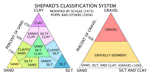 |
Figure 10. Sediment-classification scheme from Shepard (1954), as modified by Schlee (1973) and Poppe and others (2004). Special characters include %, percent; <, less than. |
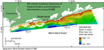 |
Figure 11. Hill-shaded multibeam bathymetry of National Oceanic and Atmospheric Administration survey H12296 in Block Island Sound. Depths are color-coded with warm colors (reds) representing shallow water and cool colors (blues) representing deep water. Also shown are the locations of detailed bathymetry and sidescan-sonar images in figures 13, 14, 15, 17, and 18. |
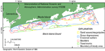 |
Figure 12. Map showing interpretations of sea-floor features in the National Oceanic and Atmospheric Administration survey H12296 study area. Features discernible on the sea floor include sand waves (and megaripples), scour depressions and erosional outliers, boulders, and trawl marks. Areas that are not outlined are predominately modern marine sediment. Interpretations are based on multibeam bathymetry, sidescan sonar, sediment samples, and bottom photography (both still and video). |
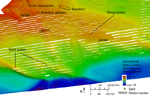 |
Figure 13. Detailed multibeam bathymetric image of sand waves, megaripples, boulders, scour depressions, and erosional outliers in the east-central part of the study area. Megaripples (20- to 90-m wavelengths) lie on the flanks of sand waves (about 500-m wavelengths). Location of image is shown in figure 11. |
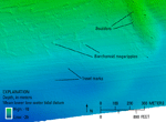 |
Figure 14. Detailed multibeam bathymetric image of barchanoid megaripples, boulders, and trawl marks in the southwestern part of the study area. The barchanoid megaripples have tails pointing towards the east, reflecting an eastward sediment transport direction. Faint troughs can be seen in the deep parts of the image, which are trawl marks caused by fishing gear dragging along the sea floor. Location of image is shown in figure 11. |
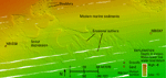 |
Figure 15. Detailed multibeam bathymetric image showing modern marine sediments surrounding scour depressions that contain erosional outliers and locations of stations NBIS47 and NBIS50. Boulders can be seen in the scour depressions along the northern edge of the image. Location of image is shown in figure 11. |
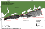 |
Figure 16. Sidescan-sonar image of National Oceanic and Atmospheric Administration survey H12296. The lighter toned areas represent high backscatter and, typically, coarser grained sediment; darker toned areas represent low backscatter and, typically, finer grained sediment. Sidescan-sonar data was not collected in the southern parts of the study area. |
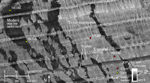 |
Figure 17. Detailed sidescan-sonar image of high-backscatter scour depressions and low-backscatter erosional outliers of modern marine sediment. In places, ripples can be seen on the floors of the scour depressions. Image also shows locations of stations NBIS40, NBIS41, NBIS44, and NBIS45. Location of image is shown in figure 11. |
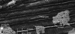 |
Figure 18. Detailed sidescan-sonar image of megaripples and boulders in the northern part of the study area. Sand waves appear as tiger striped high and low backscatter and boulders appear as high-backscatter targets with low-backscatter shadows. Location of image is shown in figure 11. |
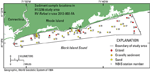 |
Figure 19. Map showing locations of sediment samples obtained during U.S. Geological Survey cruise 2012-002-FA in the H12296 study area in northern Block Island Sound. Samples in the study area range from gravel (red circles) to sand (yellow circles). |
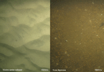 |
Figure 20. Photographs contrasting the sea floor at a station with modern marine sediment and a station within a scour depression. Rippled sand can be seen at station NBIS43 in an area of modern marine sediments and pea gravel is on the floor of the nearby scour depression at station NBIS41. Photograph locations are shown in figure 21. |
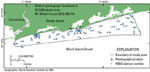 |
Figure 21. Map showing locations of the bottom photographs taken during U.S. Geological Survey cruise 2012-002-FA in the H12296 study area in northern Block Island Sound. |
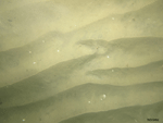 |
Figure 22. Photograph of the sea floor at station NBIS49 showing a sandy sea floor with symmetrical oscillation ripples and scattered shell debris. Photograph location is shown in figure 21. |
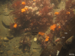 |
Figure 23. Photograph of the sea floor at station NBIS29 showing boulders covered with sponges, possible tunicates, hydrozoans, and algae. A fin fish can be seen under some kelp. Sand, pea gravel, and cobbles are also present. Photograph location is shown in figure 21. |

