Open-File Report 2014–1018
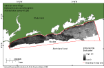
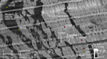
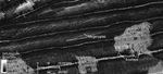
The sidescan-sonar mosaic shows areas of high and low backscatter (fig. 16). High-backscatter areas (light tones) indicate strong acoustic reflectivity, hard sea floor, and generally coarser grained sediment; low-backscatter areas (dark tones) indicate weak acoustic reflectivity, soft sea floor, and generally finer grained sediment or acoustic shadows. The data show that there is generally high backscatter in the eastern part of the study area, and low backscatter along the shore and in areas of the central and western parts of the study area. Sidescan-sonar data were not collected in the southern part of the study area. Scour depressions are easily visible as areas of high backscatter, which reflects their coarser grained sediment, whereas the surrounding modern marine sediments and erosional outliers within the depressions are denoted by a sharp contrast to dark-toned, low backscatter areas that reflects their finer grained sediment (fig. 17). Ripples or small megaripples of gravelly sediment with east-west oriented (roughly parallel to shore) crests can be seen in the sidescan-sonar data in some of the scour depressions (fig. 17). Although these ripples are smaller than the resolution of the bathymetric data, they are visible in the high resolution (1-m) sidescan-sonar data as parallel lines of alternating high and low backscatter. The ripple orientation suggests a sediment bedload transport direction within these features that is perpendicular to shore, most likely in an offshore direction if they are associated with downwelling. This agrees with modeling by Gutierrez and others (2005), which suggests cross-shore bedload transport in similar depressions (also called sorted bedforms) off the coast of North Carolina; however, they believe these features are also associated with alongshore suspended-sediment transport. Thus, suspended fine material is likely moved parallel to the coast from one area of modern marine sediment to the next, unable to fall out of suspension in the scour depressions as a result of the increased turbulence (Murray and Thieler, 2004). Two other features distinguished in the sidescan sonar, boulders and bedforms (sand waves and megaripples) were previously discussed in detail in the bathymetry section of this report (fig. 18). Boulders are visible as high-backscatter targets with low-backscatter shadows. Sand waves and megaripples are visible in the mosaic as tiger-striped, high and low backscatter. |

![]() U.S. Department of the Interior |
U.S. Geological Survey
U.S. Department of the Interior |
U.S. Geological Survey
URL: http://pubsdata.usgs.gov/pubs/of/2014/1018/html/sidescan.html
Page Contact Information: GS Pubs Web Contact
Page Last Modified: Wednesday, 07-Dec-2016 19:34:08 EST