Open-File Report 2014–1018
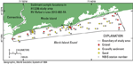
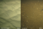
Sediment DistributionJust over half of the stations in the study area are sand, and gravel or gravelly sediment was observed at the remaining stations (fig. 19). No silty sand or finer grained muddy sediments were encountered; all samples contained less than 4 percent mud. Sand is found in areas where modern marine sediments cover the sea floor. Gravel and gravelly sediment are found in scour depressions and areas where boulders are present. Scour depressions have coarser mean-sediment sizes, that range from -2.06 to 1.30 phi and average -0.04 phi, than the surrounding modern marine sediments, that range from 1.25 to 3.29 phi and average 2.36 phi (fig. 20). Scour depressions tend to have poorly and very poorly sorted sediment, whereas most of the modern marine sediment is moderately well sorted. Sample stations were occupied along several transects that were oriented perpendicular to the shore, and efforts were made to obtain samples from transects through large scour depressions and modern marine sediments. We were able to obtain samples from only one transect in a scour depression, which indicated sediment coarsening in an offshore direction with a mean grain size of 1.30 phi at station NBIS60 close to shore, and a mean grain size of 0.03 phi at NBIS57 further offshore. The samples from transects crossing modern marine sediments did not show a trend of either fining or coarsening offshore, although the finest sediment was often found in the middle of the transect with coarser sediment close to shore, and the coarsest sediment offshore, such as in stations NBIS49, NBIS48, and NBIS47. Sediment DataThe sediment grain-size dataset provided in this report contains information on the collection, description, and texture of sediments at the 43 stations in the study area. Sediments were sampled at only 27 of the stations owing to either a coarse-grained sea floor or rough sea state that prevented a sample from being acquired. Stations where samples could not be obtained were visually classified based on video and still photography from the station. These stations have no-data values (-9999) in the textural and statistical sections of the sediment dataset. The basic structure of the dataset is laid out in a matrix, where rows represent individual samples and columns (fields) contain sample- and station-specific information. This matrix consists of 42 fields that are defined in the Data Dictionary below. A .zip file in the Geographic Information System Data Catalog section contains the sediment data in three formats (a shapefile, a Microsoft Excel spreadsheet, and a comma-delimited ASCII text file) along with metadata. Data DictionaryAn integral part of any database is the dictionary that explains the structure and content. It contains a list of the fields and definitions of parameters measured. Data utilization is facilitated by reference to this compilation because it defines abbreviations and lists field names. LABNO - Unique sample identifier assigned in the laboratory STATIONID - Sample name or number assigned in the field PROJECT - Project under which samples were taken or data were generated CRUISEID - Name or number of cruise on which the sample was collected or station was occupied PRINCIPAL - Name of the principal investigator LATITUDE - Latitude in decimal degrees (north latitudes are positive values) LONGITUDE - Longitude in decimal degrees (west longitudes are negative values) DEPTH_M - Depth of water overlying sediment at the time of sampling, measured by a hull-mounted fathometer, corrected for draft, but not corrected for tides, in meters T_DEPTH - Top depth of the sample below the sediment-water interface, in centimeters B_DEPTH - Bottom depth of the sample below the sediment-water interface, in centimeters DEVICE - Device used to collect the sample MONTH - Number of calendar month during which the sample was collected DAY - Calendar day on which the sample was collected YEAR - Calendar year during which the sample was collected WEIGHT - Dry weight of sample, in grams ZGRAVEL - Gravel content in percent of dry weight of the sample (particles with nominal diameters greater than 2 mm; -1 phi and larger) ZSAND - Sand content in percent of dry weight of the sample (particles with nominal diameters less than 2 mm but greater than or equal to 0.0625 mm; 0 through 4 phi, inclusive) ZSILT - Silt content in percent of dry weight of the sample (particles with nominal diameters less than 0.0625 mm but greater than or equal to 0.004 mm; 5 through 8 phi, inclusive) ZCLAY - Clay content in percent of dry weight of the sample (particles with nominal diameters less than 0.004 mm; 9 phi and smaller) SEDCLASS - Sediment description based on a rigorous definition (Shepard, 1954; Schlee, 1973; Poppe and others, 2004)
MEDIAN - Middle point in the grain-size distribution, in phi units MEAN - Average value in the grain-size distribution, in phi units STDDEV - Standard deviation (root mean square of the deviations) of the grain-size distribution, in phi units (that is, sorting) SKEWNESS - Deviation from symmetrical form of the grain-size distribution KURTOSIS - Degree of curvature near the mode of the grain-size distribution PHI_11 - Weight percent of the sample in the 11-phi fraction (nominal diameter of particles greater than or equal to 0.0005 mm but less than 0.001 mm); fine clay PHI_10 - Weight percent of the sample in the 10-phi fraction (nominal diameter of particles greater than or equal to 0.001 mm but less than 0.002 mm); medium clay PHI_9 - Weight percent of the sample in the 9-phi fraction (nominal diameter of particles greater than or equal to 0.002 mm but less than 0.004 mm); coarse clay PHI_8 - Weight percent of the sample in the 8-phi fraction (nominal diameter of particles greater than or equal to 0.004 mm but less than 0.008 mm); very fine silt PHI_7 - Weight percent of the sample in the 7-phi fraction (nominal diameter of particles greater than or equal to 0.008 mm but less than 0.016 mm); fine silt PHI_6 - Weight percent of the sample in the 6-phi fraction (nominal diameter of particles greater than or equal to 0.016 mm but less than 0.031 mm); medium silt PHI_5 - Weight percent of the sample in the 5-phi fraction (nominal diameter of particles greater than or equal to 0.031 mm but less than 0.0625 mm); coarse silt PHI_4 - Weight percent of the sample in the 4-phi fraction (nominal diameter of particles greater than or equal to 0.0625 mm but less than 0.125 mm); very fine sand PHI_3 - Weight percent of the sample in the 3-phi fraction (nominal diameter of particles greater than or equal to 0.125 mm but less than 0.25 mm); fine sand PHI_2 - Weight percent of the sample in the 2-phi fraction (nominal diameter of particles greater than or equal to 0.25 mm but less than 0.5 mm); medium sand PHI_1 - Weight percent of the sample in the 1-phi fraction (nominal diameter of particles greater than or equal to 0.5 mm but less than 1 mm); coarse sand PHI_0 - Weight percent of the sample in the 0-phi fraction (nominal diameter of particles greater than or equal to 1 mm but less than 2 mm); very coarse sand PHIM1 - Weight percent of the sample in the -1-phi fraction (nominal diameter of particles greater than or equal to 2 mm but less than 4 mm); very fine pebbles (granules) PHIM2 - Weight percent of the sample in the -2-phi fraction (nominal diameter of particles greater than or equal to 4 mm but less than 8 mm); fine pebbles PHIM3 - Weight percent of the sample in the -3-phi fraction (nominal diameter of particles greater than or equal to 8 mm but less than 16 mm); medium pebbles PHIM4 - Weight percent of the sample in the -4-phi fraction (nominal diameter of particles greater than or equal to 16 mm but less than 32 mm); coarse pebbles PHIM5 - Weight percent of the sample in the -5-phi fraction (nominal diameter of particles greater than or equal to 32 mm); very coarse pebbles to boulders |

![]() U.S. Department of the Interior |
U.S. Geological Survey
U.S. Department of the Interior |
U.S. Geological Survey
URL: http://pubsdata.usgs.gov/pubs/of/2014/1018/html/seds.html
Page Contact Information: GS Pubs Web Contact
Page Last Modified: Wednesday, 07-Dec-2016 19:34:07 EST