Open-File Report 2014–1018
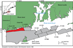
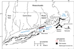
Block Island Sound is located south of Rhode Island, north and west of Block Island, and between Long Island Sound in the west and Rhode Island Sound in the east (figs. 1 and 2). The sea floor of Block Island Sound, like those of the surrounding sounds, reflects a history of Pleistocene glaciation, reworking of glacial and transitional deposits during the subsequent marine transgression associated with the eustatic rise in sea level, and the effects of scour and sediment redistribution by modern marine conditions. The Laurentide Ice Sheet reached its maximum extent around 20,000 to 28,000 years ago at the location marked by the Ronkonkoma-Nantucket terminal moraine (Stone and Borns, 1986; Uchupi and others, 2001; Ridge, 2003; Balco, 2011; fig. 2). During the northward retreat of the ice sheet, the Harbor Hill-Roanoke Point-Charlestown-Buzzards Bay end moraine was constructed around 18,000 to 23,000 years ago (Uchupi and others, 2001; Balco, 2011). As the ice sheet retreated, ponded meltwater formed glacial lakes between the ice front and the end moraines. Glaciolacustrine sediments tens to hundreds of meters thick were deposited in these lakes, which covered much of modern day Long Island, Block Island, and Rhode Island Sounds (Needell and others, 1983; Lewis and DiGiacomo-Cohen, 2000; Uchupi and others, 2001; Boothroyd, 2009). After the glacial lakes drained, these areas were exposed to subaerial erosion before the sea level rose and the shoreline transgressed northward. This transgression eroded and reworked the glacial and transitional sediments and left a coarse-grained lag (Knebel and others, 1982). Modern currents and waves continue to erode, sort, and rework the sea floor and, where currents are weaker, deposit modern marine sediments (Knebel and others, 1982; Needell and Lewis, 1984). |

![]() U.S. Department of the Interior |
U.S. Geological Survey
U.S. Department of the Interior |
U.S. Geological Survey
URL: http://pubsdata.usgs.gov/pubs/of/2014/1018/html/setting.html
Page Contact Information: GS Pubs Web Contact
Page Last Modified: Wednesday, 07-Dec-2016 19:34:07 EST