Open-File Report 2014-1221

|
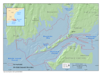
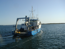
IntroductionThis report presents sea-floor sampling data and the biological classification of sea-floor photographs collected in 2010 from Buzzards Bay and Vineyard Sound, Massachusetts (fig. 1). The survey area covered approximately 670 square kilometers of the sea floor that was also mapped with geophysical systems between 2009–2010 in water depths from 3 to 46 meters (m). This report adds to the series of data reports (Ackerman and others, 2006, 2013; Andrews and others, 2010, 2013; Barnhardt and others, 2006, 2009, 2010; Pendleton and others, 2011; Turecek and others, 2012) produced by a cooperative mapping program of the U.S. Geological Survey (USGS) and the Massachusetts Office of Coastal Zone Management (CZM) (web address: http://woodshole.er.usgs.gov/project-pages/coastal_mass/). The sea-floor sampling data in this report were obtained during a USGS research cruise in 2010 aboard the research vessel (RV) Connecticut (fig. 2). These data were collected to verify the geophysical data obtained during USGS research cruises in 2009 and 2010 (aboard the motor vessel (MV) Megan T. Miller and the MV Scarlett Isabella) and one National Oceanic and Atmospheric Administration (NOAA) hydrographic survey in 2004 (aboard the NOAA Ship RUDE). The overall goal of this cooperative program is to characterize the sea floor and shallow subsurface inside the 3-mile limit of State waters by using high-resolution geophysical techniques, sediment sampling, and sea-floor photography and videography. The products developed and knowledge gained in this project have broad applicability to scientific and resource-management issues in the region. Sampling data are used to verify interpretations made from seamless geophysical datasets and are a key component of geologic and habitat mapping efforts. Seabed-characterization maps and geospatial data collected and published through this mapping cooperative help scientists understand the processes that have shaped the coast, and how it has evolved over time, thereby helping them to evaluate the vulnerability of coastal environments to storms, sea-level rise, and long-term climate change. This report adds to a science foundation that will be the basis for managing marine habitats, addressing offshore development projects, and assessing environmental changes caused by natural processes or human activities. |

![]() U.S. Department of the Interior |
U.S. Geological Survey
U.S. Department of the Interior |
U.S. Geological Survey
URL: http://pubsdata.usgs.gov/pubs/of/2014/1221/html/ofr2014-1221-introduction.html
Page Contact Information: GS Pubs Web Contact
Page Last Modified: Wednesday, 07-Dec-2016 20:03:10 EST