Open-File Report 2014-1224
![]() Title |
List of Figures |
Conversion Factors |
Abstract |
Introduction |
Setting |
Methods |
Bathymetry |
Sidescan Sonar |
Sediments |
Bottom Photography |
Interpretation |
GIS Data Catalog |
Summary |
Acknowledgments |
References |
Contacts |
Index
Title |
List of Figures |
Conversion Factors |
Abstract |
Introduction |
Setting |
Methods |
Bathymetry |
Sidescan Sonar |
Sediments |
Bottom Photography |
Interpretation |
GIS Data Catalog |
Summary |
Acknowledgments |
References |
Contacts |
Index
 |
||
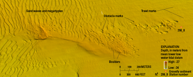
Figure 18. Detailed multibeam-bathymetric image of boulders, many with obstacle marks, sand waves and megaripples, and trawl marks, in the southeast part of the study area. Although this area was mapped by Needell and Lewis (1984) as exposed coastal plain sediments, the presence of numerous boulders indicates that the underlying deposits are covered by at least a thin layer of winnowed basal till. Sand waves and megaripples with steep, westward-facing slip faces and asymmetry of obstacle marks around boulders indicate westward net sediment transport. Trawl marks caused by dragging fishing gear appear as grooves on the sea floor in the eastern part of the image. Location of image is shown in figure 13. |
||

![]() U.S. Department of the Interior |
U.S. Geological Survey
U.S. Department of the Interior |
U.S. Geological Survey
URL: http://pubsdata.usgs.gov/pubs/of/2014/1224/html/ofr2014-1224-fig18.html
Page Contact Information: GS Pubs Web Contact
Page Last Modified: Wednesday, 07-Dec-2016 20:06:45 EST
