Open-File Report 2014-1224
![]() Title |
List of Figures |
Conversion Factors |
Abstract |
Introduction |
Setting |
Methods |
Bathymetry |
Sidescan Sonar |
Sediments |
Bottom Photography |
Interpretation |
GIS Data Catalog |
Summary |
Acknowledgments |
References |
Contacts |
Index
Title |
List of Figures |
Conversion Factors |
Abstract |
Introduction |
Setting |
Methods |
Bathymetry |
Sidescan Sonar |
Sediments |
Bottom Photography |
Interpretation |
GIS Data Catalog |
Summary |
Acknowledgments |
References |
Contacts |
Index
 |
||
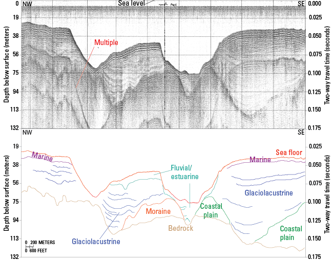
Figure 30. Seismic-reflection profile and interpretation of a section of line a81_225 (Needell and Lewis, 1984; Poppe and others, 2002), which crosses two of the eastern bathymetric depressions. These depressions are eroded into glaciolacustrine sediments, and the southern depression has formed between moraine and coastal plain sediments and filled with fluvial and estuarine sediments. A layer of fluvial and estuarine sediments overlies the glaciolacustrine sediments between the two depressions, and elsewhere modern marine sediments overlie the glaciolacustrine sediments. (Interpretations after Needell and Lewis, 1984). Location of profile is shown in figure 13. |
||

![]() U.S. Department of the Interior |
U.S. Geological Survey
U.S. Department of the Interior |
U.S. Geological Survey
URL: http://pubsdata.usgs.gov/pubs/of/2014/1224/html/ofr2014-1224-fig30.html
Page Contact Information: GS Pubs Web Contact
Page Last Modified: Wednesday, 07-Dec-2016 20:06:53 EST
