Open-File Report 2015-1149
![]() Title |
List of Figures |
Conversion Factors |
Abstract |
Introduction |
Setting |
Methods |
Bathymetry |
Sediments |
Bottom Photography |
GIS Data Catalog |
Summary |
Acknowledgments |
References |
Contacts
| Citation Page
Title |
List of Figures |
Conversion Factors |
Abstract |
Introduction |
Setting |
Methods |
Bathymetry |
Sediments |
Bottom Photography |
GIS Data Catalog |
Summary |
Acknowledgments |
References |
Contacts
| Citation Page
 |
||
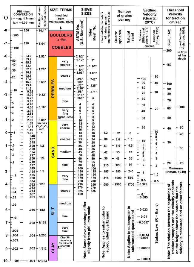
Figure 5. Chart showing the relations among phi sizes, millimeter diameters, size classifications (Wentworth, 1922), and American Society for Testing and Materials (ASTM) and Tyler sieve sizes. Chart also shows the corresponding intermediate diameters, grains per milligram, settling velocities, and threshold velocities for traction. Abbreviations in the image include cm/sec, centimeter per second; d, diameter; m, meter; mg, milligram; mm, millimeter; µm, micrometer; no., number; °C, degrees Celsius; and ", inch. Chart produced in the Woods Hole Coastal and Marine Science Center Sediment Lab. |
||

![]() U.S. Department of the Interior |
U.S. Geological Survey
U.S. Department of the Interior |
U.S. Geological Survey
URL: http://pubsdata.usgs.gov/pubs/of/2015/1149/html/ofr20151149_fig5.html
Page Contact Information: GS Pubs Web Contact
Page Last Modified: Wednesday, 07-Dec-2016 21:44:07 EST
