|

Two Months of Flooding in Eastern North Carolina, September - October 1999: Hydrologic Water-Quality, and Geologic Effects of Hurricanes Dennis, Floyd, and Irene
Water-Resources Investigations Report 00-4093
Raleigh, North Carolina 2000
By Jerad D. Bales, Carolyn J. Oblinger, and Asbury H. Sallenger, Jr.
|
III. FLOODING
 |
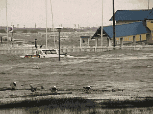
| Flooded mobile home park along the Tar River |
The record rainfall amounts from Hurricanes Dennis and Floyd led to widespread and prolonged flooding in eastern North Carolina. With the exception of the Lumber River Basin, all of the major river basins in eastern North Carolina experienced flooding at the 500-year recurrence interval (table 3; fig. 7).
|
Table 3.Hurricane Floyd flood information for selected streamgaging stations in North Carolina and Virginia.
[All sites in North Carolina, unless noted; mi2, square miles; ft, feet; ft3/s, cubic feet per second; >, greater than; nd, not determined; <, less than]
| Site no. (fig.7) |
USGS station no. |
Station name |
Drainage area (mi2) |
Period of record |
Gage datum (ft above sea level) |
1999 floods |
Previous peaks of record |
| Date |
Peak stage (ft above datum) |
Peak flow (ft3/s) |
Recurrence interval (years) |
Date |
Peak stage (ft above datum) |
Peak flow (ft3/s) |
|
Chowan River Basin |
| 1 |
02047000 |
Nottoway River near Sebrell, Va. |
1,421 |
1941-99 |
5.94 |
9/20 |
27.01 |
35,700 |
50-100 |
7/19/75 |
24.43 |
26,000 |
| 2 |
02049500 |
Blackwater River near Franklin, Va. |
617 |
1941-99 |
1.56 |
9/18 |
26.27 |
23,000 |
100-500 |
9/14/60 |
17.14 |
9,420 |
| 3 |
02051500 |
Meherrin River near Lawrenceville, Va. |
552 |
1928-99 |
136.56 |
9/18 |
29.95 |
15,590 |
10-25 |
8/17/40 |
42.00 |
38,000 |
| 4 |
02053200 |
Potecasi Creek near Union |
225 |
1958-99 |
3.53 |
9/16 |
28.9 |
17,000 |
>500 |
8/19/92 |
21.77 |
5,650 |
| 5 |
02053500 |
Ahoskie Creek at Ahoskie |
63.3 |
1964-99 |
17.46 |
9/17 |
17.32 |
8,570 |
>500 |
6/1/84 |
12.49 |
2,580a |
|
Roanoke River Basin |
| 6 |
0208111310 |
Cashie River near Windsor |
108 |
1987-99 |
15 |
9/16 |
18.52 |
15,700 |
>500 |
10/18/92 |
11.51 |
3,150 |
| Tar-Pamlico River Basin |
| 7 |
02081500 |
Tar River near Tar River |
167 |
1940-99 |
287.25 |
9/16 |
17.59 |
11,000 |
10 |
9/6/96 |
24.06 |
19,900 |
| 8 |
02081747 |
Tar River at Louisburg |
427 |
1964-99 |
176.71 |
9/17 |
26.05 |
23,700 |
50-100 |
9/7/96 |
25.34 |
21,100 |
| 9 |
02082506 |
Tar River below Tar River Reservoir |
777 |
1973-99 |
85.9 |
9/17 |
32.89 |
29,300 |
100-500 |
3/23/98 |
23.67 |
14,700 |
| 10 |
02082585 |
Tar River at Rocky Mount |
925 |
1977-99 |
53.88 |
9/17 |
31.66 |
34,100 |
100-500 |
9/12/96 |
25.88 |
15,100 |
| 11 |
02082770 |
Swift Creek at Hilliardston |
166 |
1963-99 |
130.42 |
9/17 |
21.30 |
23,000 |
>500 |
6/5/79 |
14.27 |
6,030 |
| 12 |
02082950 |
Little Fishing Creek near White Oak |
177 |
1960-99 |
116.44 |
9/16 |
30.8 |
31,000 |
>500 |
10/7/72 |
24.80 |
18,000 |
| 13 |
02083000 |
Fishing Creek near Enfield |
526 |
1923-99 |
74.26 |
9/18 |
21.65 |
30,000 |
500 |
8/18/40 |
17.72 |
12,600b |
| 14 |
02083500 |
Tar River at Tarboro |
2,183 |
1897-1905; 1931-99 |
10.37 |
9/19 |
41.51 |
70,600 |
>500 |
8/20/40 |
31.77 |
37,200 |
| 15 |
02083800 |
Conetoe Creek near Bethel |
78.1 |
1957-99 |
30 |
nd |
19.79 |
nd |
nd |
8/23/67 |
15.74 |
2,580 |
| 16 |
02084000 |
Tar River at Greenville |
2,620 |
1997-99 |
-2.36 |
9/21 |
29.72 |
73,000 |
nd |
3/28/98 |
18.08 |
25,500 |
| 17 |
02084160 |
Chicod Creek near Simpson |
45 |
1975-1987; 1992-99 |
0 |
9/18 |
21.46 |
nd |
nd |
8/27/98 |
13.45 |
3,150 |
| 18 |
02084472 |
Pamlico River at Washington |
3,125 |
1999c |
0 |
9/16 |
8.14 |
nd |
nd |
not applicable |
| 19 |
02084557 |
Van Swamp near Hoke |
23 |
1977-99 |
20 |
9/16 |
7.43 |
383 |
25 |
10/8/96 |
5.98 |
409d |
| Neuse River Basin |
| 20 |
02087183 |
Neuse River near Falls |
772 |
1981-99e |
194.69 |
10/14 |
5.95 |
6,330 |
5-10 |
9/16/96 |
8.05 |
7,650 |
| 21 |
02087324 |
Crabtree Creek at U.S. 1 at Raleigh |
121 |
1990-99 |
183.27 |
9/16 |
16.88 |
8,050 |
nd |
9/6/96 |
18.23 |
12,700 |
| 22 |
02087500 |
Neuse River near Clayton |
1,150 |
1981-99e |
128.41 |
9/17 |
20.67 |
20,500 |
25-50 |
9/7/96 |
20.12 |
19,700 |
| 23 |
02087570 |
Neuse River at Smithfield |
1,206 |
1908-91; 1999 |
99.26 |
9/18 |
26.72 |
>17,800 |
>50 |
4/29/78 |
nd |
15,800 |
| 24 |
0208758850 |
Swift Creek near McCullars Crossroads |
35.8 |
1989-99 |
258 |
9/16 |
13.06 |
3,640 |
10 |
9/6/96 |
14.15 |
6,790 |
| 25 |
02088000 |
Middle Creek near Clayton |
83.5 |
1940-99 |
184.53 |
9/16 |
13.02 |
5,270 |
10-25 |
9/6/96 |
14.88 |
11,900 |
| 26 |
02088500 |
Little River near Princeton |
232 |
1930-99 |
107.75 |
9/17 |
16.58 |
20,700 |
>500 |
10/6/64 |
13.94 |
7,150 |
| 27 |
02089000 |
Neuse River near Goldsboro |
2,399 |
1981-99e |
42.95 |
9/20 |
28.85 |
38,500 |
50 |
9/12/96 |
26.21 |
29,300 |
| 28 |
02089500 |
Neuse River at Kinston |
2,692 |
1981-99e |
10.90 |
9/22
9/23 |
27.71 |
36,300 |
50-100 |
9/17/96 |
23.26 |
27,100 |
| 29 |
02090380 |
Contentnea Creek near Lucama |
161 |
1977-99e |
117.43 |
9/16 |
25.0 |
24,000 |
100 |
10/6/64 |
16.28 |
5,860 |
| 30 |
02091000 |
Nahunta Swamp near Shine |
80.4 |
1955-99 |
50.74 |
9/17 |
21.00 |
23,000 |
>500 |
10/6/64 |
14.14 |
5,470 |
| 31 |
02091500 |
Contentnea Creek at Hookerton |
733 |
1928-99 |
14.85 |
9/18 |
28.28 |
31,900 |
>500 |
10/8/64 |
22.11 |
17,200 |
| 32 |
02091814 |
Neuse River near Fort Barnwell |
3,900 |
1996-99 |
0 |
9/20 |
22.75 |
57,200 |
nd |
2/6/98 |
14.01 |
24,300 |
| 33 |
02092500 |
Trent River near Trenton |
168 |
1951-99 |
19.15 |
9/17 |
22.33 |
15,000 |
>500 |
9/21/55 |
17.84 |
9,100 |
| New River Basin |
| 34 |
02093000 |
New River near Gum Branch |
94.0 |
1950-73; 1988-99 |
0 |
9/16 |
25.12 |
15,000 |
>500 |
9/20/55 |
19.99 |
7,900 |
| Cape Fear River Basin |
| 35 |
02096960 |
Haw River near Bynum |
1,275 |
1973-99 |
283.31 |
9/16 |
13.42 |
23,100 |
<2 |
9/6/96 |
21.76 |
76,700 |
| 36 |
02102000 |
Deep River at Moncure |
1,434 |
1931-99 |
185.06 |
9/6 |
9.15 |
23,000 |
2-5 |
9/18/45 |
17.20 |
80,300 |
| 37 |
02102500 |
Cape Fear River at Lillington |
3,464 |
1981-99e |
104.62 |
9/16 |
14.46 |
29,800 |
2 |
9/7/96 |
18.97 |
51,800 |
| 38 |
02102908 |
Flat Creek near Inverness |
7.63 |
1969-99 |
191.18 |
9/16 |
3.84 |
173 |
2-5 |
4/1/73 |
7.30 |
394 |
| 39 |
02105500 |
Cape Fear River at Lock 3 |
4,852 |
1981-99e |
28.97 |
9/17 |
21.59 |
37,500 |
10 |
9/8/96 |
26.75 |
nd |
| 40 |
02105769 |
Cape Fear River at Lock 1 |
5,255 |
1981-99e |
-2.90 |
9/20 |
23.30 |
40,000 |
5-10 |
9/11/96 |
24.29 |
48,300 |
| 41 |
02105900 |
Hood Creek near Leland |
21.6 |
1953-73; 1994-99 |
12.22 |
9/16 |
13.89 |
4,800 |
100 |
8/27/98 |
11.53 |
2,650 |
| 42 |
02106500 |
Black River near Tomahawk |
676 |
1952-99 |
24.61 |
9/18 |
27.14 |
28,500 |
100-500 |
9/17/84 |
22.08 |
17,500 |
| 43 |
02108000 |
Northeast Cape Fear River near Chinquapin |
599 |
1941-99 |
17.28 |
9/18 |
23.51 |
30,700 |
>500 |
7/6/62 |
20.16 |
20,400 |
| Lumber and Waccamaw River
Basins |
| 44 |
02109500 |
Waccamaw River at Freeland |
680 |
1939-99 |
15.52 |
9/20 |
19.30 |
31,200 |
>500 |
9/12/96 |
17.02 |
12,400 |
| 45 |
02134500 |
Lumber River at Boardman |
1,228 |
1929-99 |
72.05 |
9/19 |
10.70 |
13,400 |
25 |
9/24/45 |
10.64 |
13,400 |
| Miscellaneous stations |
| 46 |
0208453300 |
Pamlico River at Light 5 |
not applicable |
|
|
|
|
|
|
|
|
|
| 47 |
02092162 |
Neuse River at Marker 38 at New Bern |
not applicable |
|
|
|
|
|
|
|
|
|
aInstantaneous peak flow occurred on October 5, 1964.
bInstantaneous peak flow occurred on December 2, 1934.
cRecord began in June 1999.
dInstantaneous peak flow occurred on November 6, 1977.
eRegulated period of record, used to compute flood recurrence intervals.
|
|
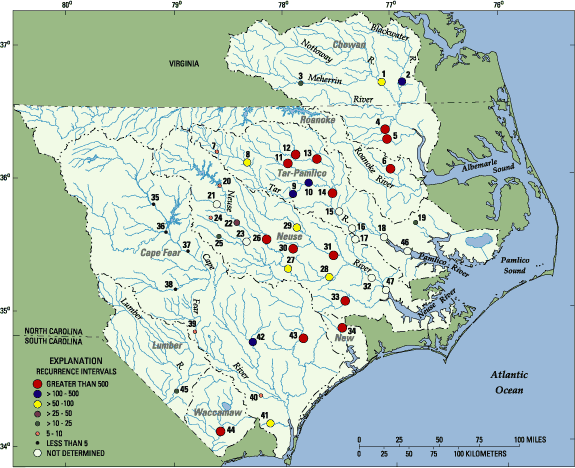 |
| Figure 7. Site locations and flood recurrence intervals for September-October 1999 flooding at selected streamgaging sites in North Carolina and Virginia. |
Tar-Pamlico River Basin
Some of the most widespread flooding occurred in the Tar-Pamlico River Basin downstream from
Louisburg (site 8, fig. 7). Record water levels were recorded at 11 of the 12 USGS streamgaging stations
in the Tar-Pamlico Basin (excluding site 18 on the Pamlico River, where previous high water levels have
been in response to storm surge). Measured flood flows on the Tar River and major tributaries downstream
from site 9 at the Tar River Reservoir had recurrence intervals in excess of 100 years, and several sites
had recurrence intervals in excess of 500 years (table 3). At Tarboro
(site 14, fig. 7), where streamflow records have been collected since 1897, the peak stage
during this event was almost 10 feet higher than the previously recorded peak stage, which occurred
in August 1940 (table 3; fig. 8). Water levels remained above flood stage at Tarboro for most of September
and October (fig. 8). The maximum flood flow at Tarboro in 1999 was almost double previous maximum flow
recorded at the site in more than 100 years. Flood recurrence intervals could not be determined at
sites 15 (Conetoe Creek) and 17 (Chicod Creek) because flows at these sites were affected by backwater
from the Tar River. An insufficient period of record (greater than 10 years is needed) was available
at sites 16 (Tar River at Greenville) and 18 (Tar River at Washington) to estimate flood recurrence intervals.
 |
| Conetoe Creek near Bethel, N.C. |
|
 |
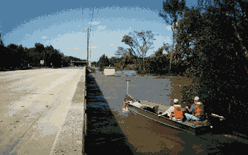
| U.S. Highway 64 near Princeville, N.C. |
|
 |
| N.C. Highway 33 flooded by the Tar River |
|
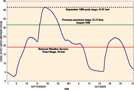 |
| Figure 8. Stage hydrograph for the Tar River at Tarboro (site 14, fig. 7), September-October 1999. |
Neuse River Basin
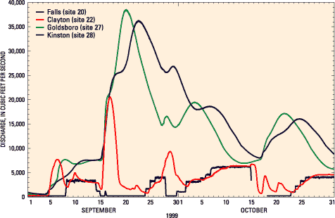
The most prolonged flooding of September-October 1999 occurred in the Neuse River Basin (fig. 9). Water levels were above flood stage at Goldsboro (site 27, fig.7) from September 7 until the end of October, and the water level at Kinston (site 28, fig. 7) was still 1.5 feet above flood stage at the end of October. There are 16 USGS streamgaging stations in the Neuse River Basin downstream from and including Clayton (site 22, fig. 7); not all sites are included in table 3 and figure 7. New records for maximum water levels were established at 14 of the 16 sites, except at Swift Creek (site 24) and Middle Creek (site 25), which are the westernmost of the
16 gages. This means that, with the exception of Swift Creek and Middle Creek, all of the record water levels recently established by Hurricane Fran downstream from Clayton were exceeded as a result of Hurricane Floyd (for example, at Goldsboro, fig. 9). Flood recurrence intervals were greater than 500 years for the Little River (site 26), Nahunta Swamp (site 30), Contentnea Creek at Hookerton (site 31), and the Trent River (site 33); maximum water
levels recorded at these sites exceeded previously established maximum values by 2.6 feet (site 26, with 80 years of record) to almost 7.2 feet at site 30, where more than 40 years of streamflow data have been recorded (table 3).
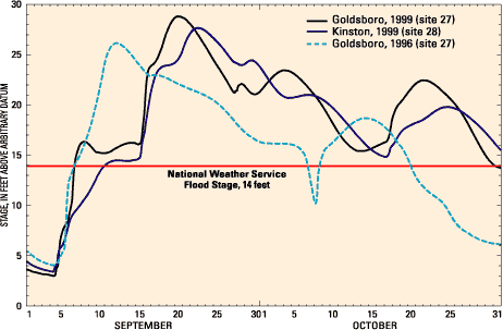 |
| Figure 9. Stage hydrographs for the Neuse River at Kinston, September-October 1999, and near Goldsboro, September-October 1996 and 1999. |
|
 |
| Storm surge flooding in Dare County |
|
Contributions to streamflow from the upper Neuse Basin (upstream from Falls Dam) were small relative to contributions downstream from Clayton (fig. 10). During September, flow at Falls Dam accounted for about 10 percent of the total flow volume at
Goldsboro and about 8 percent of the total monthly flow volume at Kinston. In contrast, the drainage area at Falls Dam
represents about 32 percent of the total drainage area at Goldsboro and about 29 percent of the drainage area at Kinston. During October, the volume of water released from Falls Dam was equivalent to about 26 percent
of the total flow volume at
Goldsboro and about 22 percent of the total flow volume at
Kinston. Hence, in both September and October, the volume of
flow contributed by Falls
Dam to the total flow at Goldsboro and Kinston was less than might be expected if the Neuse River were unregulated and if contributions to streamflow were proportional to drainage area. Another way to express the difference between flow contributions from the upper Neuse River Basin and the basin downstream from Falls Dam is in equivalent inches
of runoff. The flow
from Falls Dam
during September was equivalent to 1.9 inches of runoff from the 772-mi2 drainage basin upstream from the dam. The runoff from the 1,920-mi2 portion of the Neuse Basin between Falls Dam and Kinston during September was 8.5 inches. In comparison, the average annual runoff for the entire Neuse River Basin upstream from Kinston for the period 1983-99
(the period after the completion of Falls Dam) was about 14 inches.
 |
| Figure 10. Streamflow in the Neuse River at four locations between Falls Dam and Kinston, September-October 1999. |
|
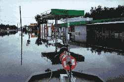 |
| Neuse River flooding in Goldsboro, N.C. Acoustic Doppler current profiler used for discharge measurements shown in the foreground on the boat bow |
|
Cape Fear River Basin
Flooding was much less widespread in the Cape Fear River Basin than in the Tar-Pamlico and Neuse River Basins. The most severe flooding occurred near Wilmington and along the Black and Northeast
Cape Fear Rivers, near the location where Hurricane Floyd made landfall. New maximum water-level records were established on Hood Creek (site 41), Black River (site 42), and
Northeast Cape Fear River (site 43), and flood recurrence intervals at those sites were between 100
and in excess of 500 years (table 3). On the Northeast Cape Fear River, the September 1999 maximum water level exceeded the previous record by almost 3.4 feet, and the peak flow was 50 percent greater than the previously recorded peak flow, which occurred in 1962
(table 3).
Other river basins
The number of streamgages in northeastern North Carolina is small relative to those in the Tar-Pamlico and Neuse River Basins, so the extent and magnitude of flooding in that region is not as easily determined. However, several streams in the Chowan River Basin experienced 50- to greater than 500-year flood flows (table 3; fig. 7). The previously recorded maximum water levels were exceeded at Potecasi Creek (site 4) and Ahoskie Creek (site 5) in North Carolina, as well as on the Nottoway (site 1) and Blackwater (site 2) Rivers in Virginia near the North Carolina-
Virginia State line (fig. 7). The previously recorded maximum water level on the Cashie River (site 6) was exceeded by 7 feet during Hurricane Floyd, and the flood recurrence interval was greater than 500 years.
The high rainfall amounts in southeast North Carolina (table 1) had a dramatic effect on the Waccamaw River (site 44; fig. 7), where streamflow has been recorded for 60 years (table 3). The maximum streamflow recorded following Hurricane Floyd was more than 2.5 times greater than the highest streamflow ever recorded at the site (table 3), and the flood-flow recurrence interval was greater than 500 years. The previous highest streamflow occurred as a result of Hurricane Fran in 1996. The maximum streamflow in the Lumber River at Boardman (site 45) was approximately equal to the highest previously recorded flow (in 1945) at the site, which has 70 years of record. The highest previously recorded water level for the New River (site 34) was established in 1955 as a result of Hurricane Ione (fig. 5; table 3). However, the maximum water level for the New River resulting from Hurricane Floyd rainfall exceeded that from Hurricane Ione by more than 5 feet (table 3), and peak flow resulting from Hurricane Floyd was almost double the 1955 peak flow.
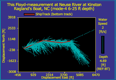 |
| Data from ADCP discharge measurement at Neuse River at Kinston, N.C. Blue-green lines show velocity direction and magnitude (scale at left) along the boat path (shiptrack, red line). Total measured discharge was 27,300 ft3/s, and total length of measurement was 4,310 feet. |
FLOOD RECURRENCE INTERVALS
A statistical technique called frequency analysis is used to estimate the probability of occurrence of a flood peak having a given magnitude. The recurrence interval (sometimes called the return period) of a peak flow is the probability that the flow will be equaled or exceeded in any given year. For example, there is a 1 in 100 (or one percent) chance that a streamflow of at least 45,500 ft3/s will occur during any year on the Tar River at Tarboro (site 14, table 3; fig. 7). Thus, a peak flow of 45,500 ft3/s at site 14 is said to have a 100-year recurrence interval, or to be the 100-year flood. This is not to say that a flow of 45,500 ft3/s will occur only once during the next 100 years, but rather that there is a 1 in 100 chance that a flow of 45,500 ft3/s will be equaled or exceeded during any given year. Moreover, from a statistical point of view, the fact that a 100-year flood occurs one year does not affect the probability of such a flood occurring the following year.
The standard procedures (Hydrology Subcommittee of the Interagency Advisory Committee on Water Data, 1982) used to
compute flood recurrence intervals from data collected at a streamgaging site are based on a number of assumptions, including the
following:
- Distribution of the logarithms of the annual peak flows can be approximated by the Pearson Type-III distribution;
- Annual peak flows are
independent;
- No trend is present in the record of annual peak flows; and
- No major changes, such as construction of an impoundment, have occurred in the watershed upstream from the site of interest.
The period of record that is used to compute flood recurrence intervals at a gaging station has a substantial effect on the computed recurrence intervals. For example, recurrence intervals for gaging stations in North Carolina were recently computed by using all available data through September 1996 (Pope and Tasker, 1999).
For the Tar River at Tarboro
(fig. 11), Pope and Tasker (1999) used data for the period 1897- 1996. The period of record used by Pope and Tasker (1999) in the analysis for the Neuse River at
Kinston (fig. 12) was 1981-1996, although records have been
collected at the site since 1928. The reason for using only the record since 1981 is that construction of Falls Dam, and thus, effects on streamflow, began that year (the dam was closed in 1983). Consequently, data prior to 1981 represent a hydrologic condition different from that after closure of the dam. Following Hurricane Floyd, flood recurrence intervals were recomputed for selected
gaging stations in eastern North Carolina to provide the best information for mitigation and rebuilding (U.S. Geological Survey, 2000).
At Tarboro, the 100-year flood that was computed by using the 1897-1999 record was about
10 percent greater than the 100-year flood that was computed by using the 1897-1996 record
(table 4). However, at Kinston, the effects of the 3 additional years of record resulted in an increase in the computed 100-year flood flow of more than 40 percent (table 4). The change in the computed 100-year flood flow at Kinston was larger than that at Tarboro because
(1) the period of record is shorter at Kinston, and the inclusion of three more flood peaks adds a larger percentage to the period of record at Kinston than at Tarboro; and
(2) not only did Hurricane Floyd occur during 1997-99, giving the highest flow during the regulated period (1981-present), but also, the fourth highest flood during the regulated flow period occurred in 1998 (fig. 12).
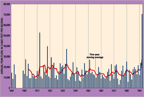 |
| Figure 11. Annual peak flows, Tar River at Tarboro, 1897-1999. |
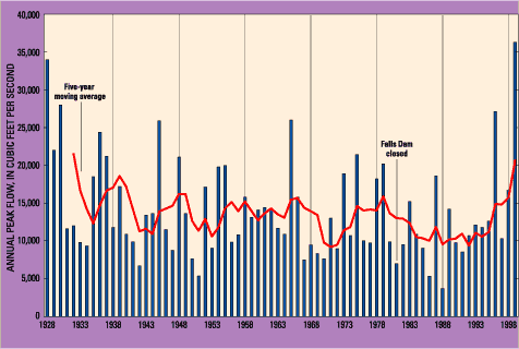 |
| Figure 12. Annual peak flows, Neuse River at Kinston, 1928-1999. |
The length of record used to compute recurrence intervals
represents a balance between the needs to (1) reduce variance in the computed recurrence intervals and (2) avoid bias in the distribution of annual peak flows (Committee on American River Flood Frequencies, 1999). It is fairly well established that decadal to centennial variations occur in climate
(perhaps now superimposed on long-term human-induced trends) that affect hydrologic conditions (National Research Council, 1998). Consequently, the longer periods of record may include
periods during which flood risk is different from the current period or the future design period. For example, four of the five largest floods during the last 102 years at Tarboro occurred during the period 1919- 40 (fig. 11). However, there is no indication that a long-term trend in annual peak flows at Tarboro exists (fig. 11). Likewise, at Kinston, 5 of the 11 flood peaks greater than 20,000 ft3/s occurred during the 10-year period 1928-37 (fig. 12).
On the other hand, a longer period of record reduces the variance in the estimated recurrence intervals. The 90-percent confidence band for the 100-year flood flow estimated for the Tar River at Tarboro is fairly narrow (table 4). However, the 90-percent confidence band for the 100-year flood estimate for the Neuse River at
Kinston, where 19 years of record were used in the analysis, is quite large and represents a range in stage of more than 5 feet. In the
relatively flat topography of the Coastal Plain, this uncertainty in the 100-year flood elevation can translate to a large uncertainty in the delineation of the regulatory 100-year floodplain.
Table 4. Effect of period of record on computed 100-year flood magnitude, Tar River at Tarboro and Neuse River at Kinston, N.C.
[ft3/s, cubic feet per second; --, not computed]
| |
Tar River at Tarboro |
Neuse River at Kinston |
| Period of Record |
1897-1996 |
1897-1999 |
1981-1996 |
1981-1999 |
| Computed 100-year flood flow, in ft3/s |
41,300 |
45,500 |
28,200 |
40,500 |
| 90-percent confidence band, in ft3/s |
-- |
39,100-53,500 |
-- |
29,300-68,700 |
|
Freshwater delivery to Pamlico Sound
Pamlico Sound is a relatively shallow lagoonal estuary with a mean depth of 16 feet and a surface area of 2,060 mi2 (Giese and others, 1985). The Sound is bounded on the seaward side by the Outer Banks, a barrier island system that restricts water exchange with the Atlantic Ocean through four small inlets. The Chowan River, Roanoke River, and several small rivers drain to Albemarle Sound, which then drains southward to Pamlico Sound or to the Atlantic Ocean through one of the four inlets. Sixty percent of the total Pamlico Sound drainage area is in the basin that drains to Albemarle Sound (table 5).
The ratio of the volume of Pamlico Sound (920 billion cubic feet [ft3]) to the average annual inflow (32,000 cubic feet per second [ft3/s]) from the entire basin, including the Albemarle Sound drainage, yields a theoretical freshwater replacement time of about 11 months. Actual residence time is likely longer for many locations in Pamlico Sound because of restricted circulation, the short-circuiting of some inflows, and the position of the tidal inlets relative to the major freshwater inflows. Long water residence times, small tidal amplitude (1.0-1.5 feet), and slow-flowing tributaries make Pamlico Sound an effective trap for dissolved and particulate matter.
Freshwater inflow to Pamlico Sound was estimated for September and October 1999. Flows were determined from data collected at the USGS network of streamgages in North Carolina and Virginia (fig. 7) and from estimates of flow from ungaged areas. Streamflow from 67.7 percent of the land area draining to Pamlico Sound is gaged. Rainfall on the surface of Albemarle Sound and Pamlico Sound was estimated from raingage and Doppler radar measurements, and the rainfall
volume was converted to a flow rate for comparison with streamflow. The volume of freshwater inflow as a percentage of Pamlico Sound volume was computed by converting the monthly mean flow rate to a total volume for the month, and then dividing the freshwater inflow
volume by the volume of Pamlico Sound. Normal inflow was computed from long-term monthly mean streamflow records. The period of streamflow record at the various streamgages used in the analysis ranged from about 15 years to more than 100 years.
Table 5. Estimated monthly mean freshwater flow from basins draining to Pamlico Sound, N.C., September and Ocotober 1999
[mi2, square miles; ft3/s, cubic feet per second]
| Basin |
Drainage area (mi2) [percentage of total Pamlico Sound drainage] |
September 1999 |
October 1999 |
| Monthly mean flow (ft3/s) |
Inflow volume as a percentage of Pamlico
Sound volume: actual [normal] |
Monthly mean flow(ft3/s) |
Inflow volume as a percentage of Pamlico
Sound volume: actual [normal] |
| Albemarle Sound subbasin |
| Roanoke |
9,776[32] |
20,040 |
5.65[1.70] |
13,410 |
3.90[1.87] |
| Chowan |
4,929[16] |
35,750 |
10.1[0.57] |
9,210 |
2.68[0.71] |
| Other drainage to Albemarle Sound |
2,722[9] |
19,720 |
5.56[0.31] |
5,930 |
1.73[0.39] |
| Rainfall on the surface of Albemarle Sound |
933[3] |
12,950 |
3.65[0.47] |
1,660 |
0.48[0.47] |
| Subtotal for Albemarle Sound subbasin |
18,360[60] |
88,460 |
25.0[3.05] |
16,800 |
8.79[3.44] |
| Neuse |
5,598[17] |
45,060 |
12.7[1.17] |
29,920 |
8.71[0.90] |
| Tar-Pamlico |
4,302[14] |
47,280 |
13.3[0.61] |
15,030 |
4.38[0.60] |
| Other drainage to Pamlico sound |
560[2] |
6,140 |
1.73[0.13] |
2,220 |
0.65[0.10] |
| Rainfall on the surface of Pamlico Sound |
2,060[7] |
22,120 |
6.23[1.55] |
5,360 |
1.56[1.54] |
| TOTAL |
30,880[100] |
209,000 |
58.9[6.50] |
82,700 |
24.1[6.58] |
Freshwater inflow volume to the head of the Pamlico River estuary (near site 18, fig. 7) during the month of September was more than 90 percent of the mean annual flow volume (table 5; Bales and Robbins, 1995). Freshwater inflow to the Neuse
River estuary (near site 47, fig. 7) was slightly less than inflow to
the Pamlico River estuary, with
September inflow equivalent to 55-60 percent of annual inflow (table 5;
Robbins and Bales, 1995). Estimated mean water residence time was about 7 days for the Pamlico and Neuse River estuaries during September, compared to a long-term annual average of 72 and 68 days for these estuaries, respectively (Bales and Robbins, 1995; Robbins and Bales, 1995).
 |
| USGS staff making a discharge measurement using an acoustic Doppler current profiler on the Tar River |
During September-October 1999,
the total freshwater inflow volume to Pamlico Sound was equivalent to about 83 percent of the total volume
of the Sound, whereas under normal
conditions inflow volume during these
2 months is equivalent to about 13 percent of the volume of the Sound (table 5; Giese and others, 1985). This means that by the
end of October much of the water that was in the Sound at the beginning of September could have been displaced by floodwaters.
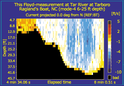 |
| Results of ADCP measurements at Tar River at Tarboro, N.C., showing cross-sectional distribution of velocity. Negative velocities in the center of the channel are about 5 feet per second and are oriented downstream. Note upstream eddies along the left edge. Total measured discharge was 33,600 ft3/s, and the width of the measured cross section was 1,120 feet. |
In September alone, the freshwater inflow to Pamlico Sound was about an order of magnitude greater than normal (table 5). Although the Roanoke River Basin comprises almost one-third of the total Pamlico Sound drainage area, freshwater inflow from this basin accounted for only about 10 percent of the total inflow to the Sound because of (1) the presence of a large flood-control reservoir near the downstream end of the basin and (2) the paths of the hurricanes, which avoided much of the basin (fig. 2). On the other hand, the Neuse and Tar-Pamlico River Basins, which together compose about
31 percent of the Pamlico Sound drainage area, contributed about 44 percent of the inflow to the Sound in September, and more than half of the inflow to the Sound in October. This is particularly important because both of these rivers drain directly to Pamlico Sound and because these rivers are known to carry relatively high loads of nutrients and other contaminants (North Carolina Department of Environment, Health, and Natural Resources, 1993, 1994; Harned and others, 1995).
 |
| Tar River at Greenville, N.C. |
Last modified: Wed Dec 13 17:42:58 EST 2000