 |
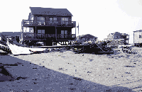
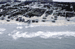
| Houses near surf in Rodanthe, N.C. |
The combined effects of Hurricanes Dennis, Floyd, and Irene in September and October 1999 resulted in 2 months of flooding throughout most of eastern North Carolina. Hurricane Dennis battered the Outer Banks for almost a week in early September, resulting in severe shoreline erosion in some locations near Buxton and Rodanthe. Upon making landfall less than 2 weeks before Hurricane Floyd, Hurricane Dennis delivered 4 to 8 inches of rain to much of the Tar and Neuse River Basins, breaking a drought and saturating soils. Hurricane Floyd will likely be the second or third most costly hurricane to strike the United States in the 20th century, resulting in more fatalities than any hurricane to strike the United States since 1972. Rainfall amounts recorded during Hurricane Floyd (September 14-17, 1999) and accumulated during the months of September and October were unprecedented for many parts of eastern North Carolina during more than 80 years of precipitation records. Most recording stations in eastern North Carolina received at least half the average annual rainfall during the 2 months. Flooding was at record levels, and 500-year or greater floods occurred in all of the State's river basins east of Raleigh. More than half of the average annual nitrogen and phosphorus loads were transported in the Neuse and Tar Rivers by floodwaters during the 1-month period between mid-September and mid-October. Shoreline erosion from the passage of Hurricane Floyd was particularly severe along Oak and Topsail Islands; the effects of Hurricane Floyd on shoreline erosion and dune retreat were greater than the effects of Hurricane Bonnie in 1998. Fortunately, Hurricane Irene in mid-October did not make landfall in North Carolina, but rainfall from the storm did help ensure that several rivers in eastern North Carolina remained above flood stage for almost 2 months.
HURRICANES IN NORTH CAROLINA
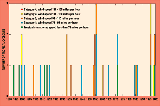
Reports of intense summer storms in eastern North Carolina began soon after the first European visits to the region. Sir Francis Drake reported "a great storm" that persisted for 3 days in June 1586 at Roanoke Island (Stevenson, 1989). A 6-day "tempest" in August 1587 again affected Drake and his fleet, who were forced to ride out the storm offshore from Roanoke Island. Between 1886, when reliable records began, and 1999, a total of 990 tropical cyclones (low- pressure systems that form over warm tropical ocean waters between June and November) have been recorded in the Atlantic Ocean and Gulf of Mexico (State Climate Office of North Carolina, 1999a). During this 114-year period, 33 tropical cyclones (about 3 percent of the total) made direct landfall in North Carolina, or an average of about one every 3.4 years (fig. 1). An average of about 6 hurricanes (tropical cyclones with wind speeds exceeding 74 miles per hour [mph]) form each year in either the Atlantic Ocean or Gulf of Mexico. Of the 33 cyclones that made landfall in North Carolina during 1886-1999, 26 were hurricanes (fig.1). Hurricane Hazel (1954) is the only Category 4 storm (wind speeds between 131 and 155 mph) that has made landfall in North Carolina since 1886. Three Category 3 storms (wind speeds between 111 and 130 mph) have entered the State during the last 114 years, but two of these storms occurred in the last 4 years - Hurricane Fran in 1996 and Hurricane Bonnie in 1998. In fact, as many hurricanes and tropical storms have made landfall in North Carolina during the 4-year period 1996-99 as during the 35-year period between 1961 and 1995 (fig. 1). The remnants of hurricanes that made landfall in other states also have had a significant effect on North Carolina. Winds from Hurricane Hugo caused extensive damage in Charlotte and other parts of the western Piedmont in 1989. Costly flooding occurred in Mecklenburg County in 1995 and again in 1997 as the remnants of Tropical Storm Jerry (1995) and Hurricane Danny (1997) passed through the State. Flood damage in Mecklenburg County exceeded $4 million in 1995 and more than $60 million in 1997 (Robinson and others, 1998). Floods having recurrence intervals of 100 years or greater occurred on some streams in Mecklenburg County during both of these events. Three of the four most costly hurricanes in U.S. history have made landfall in or passed through North Carolina (National Hurricane Center, 1999a). The most costly hurricane in U.S. history was Hurricane Andrew (1992), which passed through Florida and caused an estimated $26.5 billion in damages (National Hurricane Center, 1999a). Hurricane Hugo (1989), which made landfall in South Carolina but passed through the western Piedmont of North Carolina, caused an estimated $7 billion in damages and was the second most costly hurricane. However, estimates of losses due to Hurricane Floyd in North Carolina alone are nearly $6 billion (Raleigh News and Observer, 1999), so this storm could become the second, or certainly the third, most costly hurricane in U.S. history. In addition, Hurricane Floyd resulted in more fatalities in the United States than any hurricane since Hurricane Agnes in 1972 (National Hurricane Center, 1999b). Prior to Hurricane Floyd, Hurricane Fran (1996) was the third most costly hurricane, resulting in estimated damages of $3.2 billion.
|
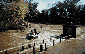 |
| USGS staff making discharge measurement during flooding on the Tar River near Rocky Mount, N.C. |
The combined effects of Hurricanes Dennis, Floyd, and Irene in September and October 1999 resulted in almost 2 months of flooding throughout most of eastern North Carolina. Hurricane Floyd resulted in more fatalities than any hurricane to strike the United States since 1972, including 52 fatalities in North Carolina (Tom Hegele, North Carolina Division of Emergency Management, written commun., January 19, 2000). Rainfall amounts recorded during Hurricane Floyd (September 14-17, 1999) and accumulated during the months of September and October were unprecedented for many parts of eastern North Carolina during more than 80 years of precipitation records. Flooding was at record levels and occurred in all of the State's river basins east of Raleigh.
The U.S. Geological Survey (USGS) is responsible for collecting and interpreting earth-science information, including flood and geologic data, for the Nation. As part of this mission, the USGS, in cooperation with the North Carolina Department of Environment and Natural Resources, the U.S. Army Corps of Engineers, the Federal Emergency Management Agency, and numerous other State and local agencies, is documenting the effects of Hurricanes Dennis, Floyd, and Irene on the water and coastal resources of North Carolina. The purpose of this report is to provide hydrologic and geologic information concerning the effects of Hurricanes Dennis, Floyd, and Irene on eastern North Carolina. Included in this report is information on the rainfall that led to the flooding, flood data, measured water- quality conditions during the flooding, and effects of the hurricanes on shoreline conditions.
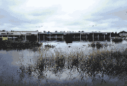
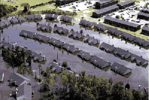 |
| Flooded subdivision in Greenville, N.C. |
R. Boyles with the North Carolina State Climate Office at North Carolina State University, provided maps showing rainfall distributions during Hurricanes Dennis and Floyd. Reviews by T. Brown, U.S. Army Corps of Engineers Wilmington District; S. Harned, National Weather Service Raleigh Forecast Office; and J. Feldt, National Weather Service Southeast River Forecast Center are gratefully acknowledged. Flood data collected under difficult conditions by staff from the U.S. Geological Survey offices in Raleigh, Charlotte, and Asheville, North Carolina; Pearl, Mississippi; and Columbia, South Carolina, made this report possible.
|
|
Photographs used in this report were contributed by Federal Emergency Management Agency (FEMA) [Dave Gatley and Dave Saville]; Goldsboro News-Argus [Ed Hayden]; National Aeronautics and Space Administration (NASA), Goddard Space Flight Center; National Oceanic and Atmospheric Administration (NOAA), Satellite Services Group, National Climatic Data Center; North Carolina Division of Emergency Management (NCDEM); U.S. Geological Survey, Center for Coastal Geology; U.S. Geological Survey, Earth Resources Observation Satellite (EROS) Data Center; and U.S. Geological Survey, North Carolina District Office.
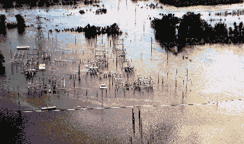 |
| Electrical substation near the Tar River, Greenville, N.C. |
Return to the |
|