|

Two Months of Flooding in Eastern North Carolina, September - October 1999: Hydrologic Water-Quality, and Geologic Effects of Hurricanes Dennis, Floyd, and Irene
Water-Resources Investigations Report 00-4093
Raleigh, North Carolina 2000
By Jerad D. Bales, Carolyn J. Oblinger, and Asbury H. Sallenger, Jr.
|
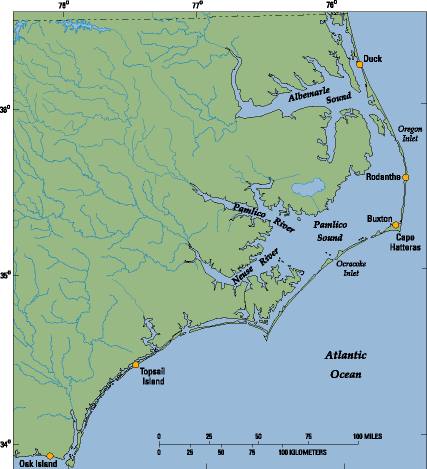
V. SHORELINE CHANGES
Hurricane Dennis approached the North Carolina coast on August 29 as a Category 2 hurricane, and eventually made landfall south of Cape
Hatteras on September 4 as a tropical storm. Although winds from Hurricane Dennis were not particularly strong, the duration of the effects of the storm on North Carolina's shoreline was remarkable. Hurricane
Dennis meandered about 150 miles off the coast of the northern Outer Banks for nearly a week, generating large waves that pounded the coast. In fact, at a buoy located in 65 feet of water near the U.S. Army Corps of Engineers Research Pier at Duck (fig. 23), the maximum wave height during Hurricane Dennis was 20.5 feet, which was the third highest wave height documented at the site in more than 20 years of record. Sea level, which includes the effects of both astronomical tides and storm surge, was also near record heights at the Research Pier during the prolonged storm. Storm tides were 3 to 5 feet above normal along much of the North Carolina coast on both August 30 and again on September 4 (Beven, 2000). According to preliminary calculations, the elevation of wave runup on the beach at Duck (that is, the highest reach of the waves) was among the highest on record. These kinds of calculations are being used to understand the distribution and magnitude of dune retreat, a major effect of the storm on the Outer Banks. Along the northern Outer Banks, from near the Virginia-North Carolina State line to south of Cape Hatteras at Ocracoke Inlet, dunes are prominent geologic features and afford the first line of defense against storm erosion and wave overwash.
 |
| Figure 23. Locations at which shoreline change and overwash were documented. |
In order to measure the amount of shoreline change resulting from Hurricane Dennis, the USGS, in cooperation with National Aeronautics and Space Administration (NASA) and National Oceanic and Atmospheric Administration (NOAA), conducted an airborne laser altimetry survey of the northern Outer Banks using NASA's Airborne Topographic Mapper (ATM) on September 8, immediately following the storm. These data were compared to a survey completed 1 year prior to the storm. Initial analyses indicate that erosion of dunes between Cape Hatteras and Oregon Inlet was highly variable along the coast. In some areas,
dunes retreated more than 100 feet, whereas in other areas the dunes were stable.
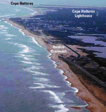
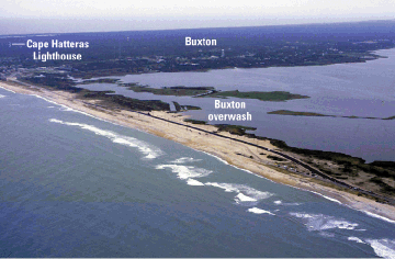
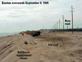
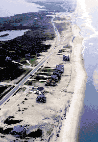
Overtopping and overwash occurred at some locations along the Outer Banks, seriously affecting N.C. Highway 12 (figs. 24, 25,
and 26). Before Hurricane Dennis, the dunes at a location north of
Buxton (fig. 23) were nearly 20 feet high (fig. 26). Replacement dunes were constructed by using bulldozers
following the storm, and were located landward of the original
dune line. The replacement dunes were approximately 5 feet lower
than the dunes destroyed during the storm.
|
|
| Figure 24. Storm wave overwash along N.C. Highway 12 north of Buxton, N.C., September 8, 1999.
|
 |
| Figure 25. Former location of N.C. Highway 12 near Buxton and replacement dunes. |
|
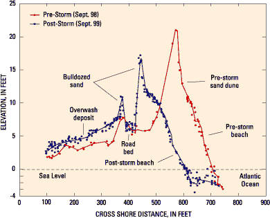 |
| Figure 26. Cross-shore profiles of the area north of Buxton where N.C. Highway 12 was destroyed. Profiles were obtained after Hurricane Dennis by using laser altimetry. The pre-storm dune was completely eroded, and the area was overwashed. After the storm, a new dune was created using bulldozers. |
|
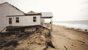
Another heavily eroded area at Rodanthe (fig. 23) led to the condemnation (fig. 27) and loss of several ocean-front houses. The laser altimetry data clearly reveal the lost houses (fig. 28). This spatial variability of high erosional rates and lower erosional rates was repeated along the coast over scales of miles, and may be related to varying nearshore geology. Identification of the causes of the variability in erosional rates is a major research objective of the USGS Coastal and Marine Geology Program.
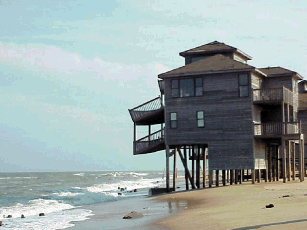 |
| Figure 27. Houses standing in the surf at Rodanthe, N.C. With no protective dunes remaining to protect the houses, the balcony supports were destroyed during the storm. These houses have been condemned. |
Whereas Hurricane Dennis was notable because of duration, Hurricane Floyd at one time was one of the strongest storms to threaten the eastern coast of the United States this century. Hurricane Floyd made landfall with sustained winds of 110 mph and a storm surge of about 10 feet (Pasch and others, 2000). The maximum surge occurred near high tide contributing substantially to extensive overwash, dune retreat, and damage to homes on barrier islands such as Oak and Topsail Islands
(fig. 23). As was done following Hurricane Dennis on the northern Outer Banks, shoreline topography was measured using airborne laser altimetry immediately following
Hurricane Floyd.
Initial results indicate that the effects of Hurricane Floyd on shoreline erosion and dune retreat were greater than the effects of Hurricane Bonnie, a Category 3 storm that made landfall in the same area in 1998.
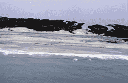 |
| Ocean overwash resulting from Hurricane Floyd |
|
 |
| Houses near the surf with little or no protective dunes, Oak Island, N.C. |
|
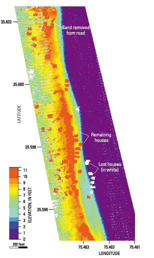 |
| Figure 28. Post Hurricane Dennis topography using laser altimeter data of an area near Rodanthe, N.C. The dark blue/purple colors are water. Note the red "rectangles" which indicate houses that survived the storm. The white "rectangles" are houses observed in pre-storm topography that were destroyed during the storm. |
|
 |
| House at Topsail Beach now located seaward of dunes after Hurricane Floyd |
|
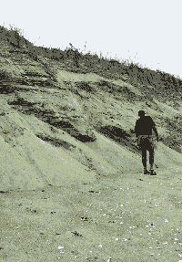 |
| Extensive dune erosion resulting from Hurricane Dennis, northern Outer Banks |
|
Last modified: Wed Dec 13 12:48:26 EST 2000