|
Two Months of Flooding in Eastern North Carolina, September - October 1999: Hydrologic Water-Quality, and Geologic Effects of Hurricanes Dennis, Floyd, and IreneWater-Resources Investigations Report 00-4093
|
Floods can transport tremendous quantities of material from the land surface into the stream system, inundate areas that are contaminated with a variety of substances, flood wastewater-treatment facilities that may be located in or near the floodplain, and result in the failure of animal waste lagoons. The large volume of water transported during the Hurricane Floyd flooding demonstrated that even low concentrations of pollutants can result in the transport of extremely high loads (or mass) of these materials through the stream system and ultimately to the estuaries of eastern North Carolina. The somewhat limited water-quality sampling that was conducted following Hurricane Fran (Bales and Childress, 1996) proved to be very informative because little is known about water-quality conditions during extremely large floods. Water- quality samples were collected during the flooding that followed Hurricane Floyd in order to better document and understand the transport of nutrients, metals, pesticides, and other pollutants during extreme floods; to document loadings of pollutants transported to the coastal waters; to compare Hurricane Floyd water-quality conditions with those resulting from Hurricane Fran; and to provide a basis for understanding possible future environmental changes (such as accelerated estuarine eutrophication) that may result from the floods.
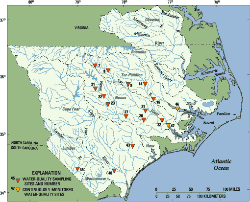 |
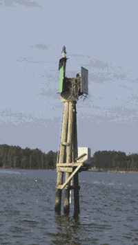
| Figure 13. Sites at which water-quality samples were collected by the USGS in September-October 1999, following Hurricane Floyd. |
Floodwater-quality samples were collected at 15 sites (fig. 13; table 6) beginning on September 16, 1999, following the passage of Hurricane Floyd through the State, and continuing through October 5, 1999. Five sites on the Tar River from Tar River (site 7) to Greenville (site 16) were
sampled; five sites were sampled on the mainstem of the Neuse River from Clayton (site 22) to Fort Barnwell (site 32) and two Neuse River tributary sites were sampled; the Cape Fear River at Lock 1 (site 40) was sampled, as were the Northeast Cape Fear River near Chinquapin (site 43) and the Lumber River at Boardman (site 45). Samples were collected on the day of the peak
discharge on the Tar River from
Louisburg to Greenville (sites 8, 9, and 16), except at Tarboro (site 14), where the first sample was collected 2 days after the peak at 93 percent of the peak discharge. The Tar River
near Tar River (site 7) was sampled the day following the peak when the flow was about 50 percent of the peak discharge. Peak or near peak discharges were sampled on the Neuse River at Clayton (site 22), Smithfield (site 23), and Fort Barnwell (site 32). The Neuse River at Goldsboro (site 27) and Kinston (site 28) were sampled within 3 days in advance of the peak at 63 and 75 percent of the peak discharge, respectively. Two tributaries, Crabtree Creek (site 21) and Contentnea Creek at Hookerton (site 31), were sampled at about 75 percent of the peak flow and after the peak discharge had occurred. In the Cape Fear and Lumber River Basins, samples were collected within 3 days after the peak discharge. The Cape Fear River at Lock 1 (site 40) was sampled at
72 percent of the peak, the Northeast Cape Fear River (site 43) at 60 percent, and the Lumber River at
Boardman (site 45) at 92 percent.
| Site no. (fig.13) | Site name | Date | Flow (ft3/s) | Data collected | ||||||
| Physicala | Suspended Sediment | Nutrientsb and organic carbon | Bacteriac | Metalsd | VOCse | Pesticidesf | ||||
| Tar-Pamlico River Basin | ||||||||||
| 7 | Tar River near Tar River | 9/17 | 4,940 | yes | yes | yes | yes | yes | no | yes |
| 9/19 | 156 | yes | yes | yes | no | yes | no | yes | ||
| 10/5 | 81.3 | yes | no | no | no | no | no | no | ||
| 8 | Tar River at Louisburg | 9/17 | 23,400 | yes | yes | yes | yes | yes | no | yes |
| 9/19 | 5,190 | yes | yes | yes | no | yes | no | yes | ||
| 10/5 | 644 | yes | no | no | no | no | no | no | ||
| 9 | Tar River below Tar River Reservoir | 9/17 | 24,000 | yes | yes | yes | no | yes | no | yes |
| 9/19 | 18,800 | yes | yes | yes | no | yes | no | yes | ||
| 9/23 | 2,240 | yes | yes | yes | yes | no | no | no | ||
| 10/5 | 1,700 | yes | no | no | no | no | no | no | ||
| 14 | Tar River at Tarboro | 9/21 | 65,400 | yes | yes | yes | yes | yes | no | yes |
| 9/27 | 23,200 | yes | yes | yes | no | yes | yes | yes | ||
| 10/5 | 13,000 | yes | yes | yes | yes | yes | yes | yes | ||
| 16 | Tar River at Greenville | 9/20 | 71,800g | no | no | no | yes | no | no | no |
| 9/21 | 72,300 | yes | yes | yes | yes | yes | no | yes | ||
| 9/29 | 29,600 | yes | yes | yes | no | yes | yes | yes | ||
|
Neuse River Basin |
||||||||||
| 21 | Crabtree Creek at U.S.1 at Raleigh | 9/16 | 6,010 | yes | yes | yes | no | yes | no | yes |
| 22 | Neuse River near Clayton | 9/17 | 20,400 | yes | yes | yes | yes | yes | no | yes |
| 9/19 | 2,620 | yes | yes | yes | no | yes | no | yes | ||
| 9/20 | 1,880 | yes | yes | yes | yes | yes | no | yes | ||
| 9/28 | 7,260 | yes | no | no | no | no | no | no | ||
| 23 | Neuse River at Smithfield | 9/17 | 22,300h | yes | yes | yes | no | yes | no | yes |
| 9/19 | 15,300h | yes | yes | yes | no | yes | no | yes | ||
| 9/20 | 8,020h | yes | yes | yes | yes | yes | no | yes | ||
| 9/28 | 6,670h | yes | no | no | no | no | no | no | ||
| 27 | Neuse River near Goldsboro | 9/17 | 22,500 | yes | yes | yes | yes | yes | no | yes |
| 9/28 | 16,400 | yes | yes | yes | yes | no | no | yes | ||
| 28 | Neuse River at Kinston | 9/20 | 27,300 | yes | yes | yes | yes | yes | no | yes |
| 9/28 | 25,600 | yes | yes | yes | yes | no | no | yes | ||
| 31 | Contentnea Creek at Hookerton | 9/21 | 26,500g | yes | yes | yes | yes | yes | no | yes |
| 32 | Neuse River near Fort Barnwell | 9/22 | 55,300g | yes | no | yes | yes | yes | no | yes |
|
Cape Fear River Basin |
||||||||||
| 40 | Cape Fear River at Lock 1 | 9/23 | 28,600 | yes | yes | yes | yes | yes | no | yes |
| 9/30 | 17,200 | yes | no | yes | yes | yes | yes | yes | ||
| 43 | Northeast Cape Fear River near Chinquapin | 9/21 | 16,800 | yes | yes | yes | yes | yes | no | yes |
| 9/24 | 8,500 | yes | no | yes | no | yes | no | no | ||
| 9/30 | 3,580 | yes | no | no | yes | no | no | no | ||
|
Lumber River Basin |
||||||||||
| 45 | Lumber River at Boardman | 9/21 | 12,500 | yes | yes | yes | yes | yes | no | yes |
| 9/23 | 11,000 | yes | no | no | no | no | no | no | ||
| aIncludes water temperature, specific conductance, dissolved oxygen concentration, and pH. bIncludes dissolved ammonia, dissolved nitrite plus nitrate, total Kjeldahl nitrogen, total nitrogen (calculated), total phosphorus, total orthophosphorus, suspended organic carbon, and dissolved organic carbon. cIncludes E.coli and C. perfringens. dIncludes dissolved manganese, copper, arsenic, lead, selenium, chromium, cadmium, mercury, iron, zinc, nickel, and beryllium. eSamples were analyzed for concentrations of seven volatile organic compounds. fSamples were analyzed for concentrations of 47 pesticides. gEstimated mean daily value. hDischarge values estimated from 1983 stage-discharge rating. | ||||||||||
Samples were analyzed for nutrients, trace metals, dissolved and suspended organic carbon, suspended sediment, and Escherichia coli (E. coli) and Clostridium perfringens (C. perfringens) bacteria (table 6). In addition, 28 samples were analyzed for 47 pesticide compounds and 4 samples were analyzed for 7 volatile organic compounds related to fuels. Dissolved oxygen concentrations, pH, specific conductance, and water temperature were measured at all sites. Analyses reported for nitrate plus nitrite are given herein as nitrate concentrations because nitrite concentrations were less than reporting levels. All nitrogen species are reported in milligrams per liter as nitrogen (N). Results are compared to other water-quality samples collected by the USGS since 1990 at the Tar River at Tarboro; the Neuse River near Clayton, at Smithfield, near Goldsboro, at Kinston, and near Fort Barnwell; Contentnea Creek at Hookerton; and the Cape Fear River at Lock 1, including samples collected at most of these sites during flooding from Hurricane Fran in 1996.
 |
| USGS staff collecting water-quality samples on the Tar River |
 |
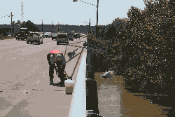
| Water-quality samples are processed on-site in specially equipped vehicles |
Dissolved oxygen concentrations less than the established minimum standard concentration of 4 milligrams per liter (mg/L) by the North Carolina Department of Environment, Health, and Natural Resources (1997) were measured in the Tar River at Tarboro and Greenville; the Neuse River at Kinston and near Goldsboro; Contentnea Creek; the Northeast Cape Fear River; and the Lumber River. Concentrations measured by the USGS during the Hurricane Floyd flooding ranged from 0.99 mg/L on the Tar River at Tarboro (site 14) to 8.7 mg/L on the Tar River at Rocky Mount (site 10), both of which occurred on September 23, or 1 week after the peak discharge at the sites. Dissolved oxygen concentrations were between 2 and 3 mg/L in the Neuse River 5 days after the peak streamflow. In the Northeast Cape Fear River, dissolved oxygen concentrations were at or below 3.5 mg/L 12 days after the peak streamflow.
Staff from the North Carolina Division of Water Quality measured dissolved oxygen concentrations at many sites throughout eastern North Carolina on September 27-28 after the flooding (North Carolina Division of Water Quality, 1999). On September 27, the median dissolved oxygen concentration at 10 sites in the Lumber River Basin was 5.2 mg/L with a minimum of 1.3 mg/L; the median concentration in the Waccamaw River Basin was 2.55 mg/L with concentrations at all 6 sites less than or equal to 2.7 mg/L. Also on September 27, the median dissolved oxygen concentration measured at 16 sites in the Tar River Basin was 4.5 mg/L with a minimum concentration of 0.17 mg/L, and a maximum concentration of 8.07 mg/L at Rocky Mount, which is where the USGS measured the maximum dissolved oxygen concentration in the Tar River. On September 28, at 11 sites in the Chowan River Basin, the median dissolved oxygen concentration was 2.5 mg/L and the minimum concentration was 1.2 mg/L.
Although dissolved oxygen concentrations were quite low, the sustained hypoxic conditions that occurred in floodwaters from Hurricane Fran did not occur after Hurricane Floyd (table 7). These somewhat higher dissolved oxygen concentrations that occurred in Hurricane Floyd floodwaters may have been the result of one or a combination of the following factors:
| Site no. (fig.13) | Station name | Hurricane Floyd Sept. 16-17, 1999 (sampled Sept. 20-21, 1999) | Hurricane Fran Sept. 5-6, 1996 (sampled Sept. 10, 1996) |
| 22 | Neuse River near Clayton | 7.5 | 5.0 |
| 23 | Neuse River near Smithfield | 4.9 | 3.8 |
| 27 | Neuse River near Goldsboro | -- | 0.4 |
| 28 | Neuse River at Kinston | 2.8 | 0.9 |
| 31 | Contentnea Creek at Hookerton | 2.9 | 1.0 |
| 40 | Cape Fear River at Lock 1 | 4.4 | 2.5 |
Specific conductance values were low compared to previous records (table 8) indicating the effects of dilution from the floodwaters of Hurricane Floyd. Likewise, pH values were about 0.5 to 1.0 standard units lower than typical values measured during the previous 9-year record. The lower pH likely was the result of the large volume of rainfall during September and October; rainfall typically has a pH of about 4.5 in eastern North Carolina (National Atmospheric Deposition Program, 1999). Measurements of pH ranged from 4.4 in the Lumber River on September 21 and 23 to about 6.5 at several locations in the Tar River on October 5.
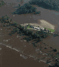 |
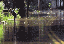
| Farm surrounded by floodwaters |
For three of the five sites for
which comparisons could be made
(table 8), maximum ammonia concentrations measured in floodwaters were approximately equal to the median concentrations measured from January
1990 to August 1999, and certainly
much less than the maximum concentrations measured during that period. However, the ammonia
concentration measured on September 23, 1999, at the Cape Fear River at Lock 1 was the highest ammonia concentration measured at the site during 1990-99. Organic nitrogen, total phosphorus, and orthophosphorus concentrations measured in floodwaters were approximately equal to median concentrations
measured from January 1990 to August 1999 (table 8). Nitrate concentrations measured in Hurricane Floyd floodwaters were low compared to previous measurements made from January 1990 to August 1999 (table 8).
| Site name [site no.] (fig. 13) | January 1990 - August 1999 | September - October 1999 | |||
| No. of samples | Maximum concentration | Minimum concentration | Median concentration | Maximum concentration [date] | |
| Specific conductance (microsiemens per square centimeter) | |||||
| Tar River at Tarboro [14] | 59 | 339 | 49 | 105 | 57 [10/5] |
| Neuse River at Smithfield [23] | 70 | 331 | 68 | 184 | 78 [9/20] |
| Neuse River at Kinston [28] | 84 | 258 | 58 | 120 | 70 [9/28] |
| Contentnea Creek at Hookerton [31] | 88 | 221 | 55 | 98 | 35 [9/21] |
| Cape Fear River at Lock 1 [40] | 22 | 186 | 54 | 108 | 90 [9/30] |
|
Ammonia (milligrams per liter) |
|||||
| Tar River at Tarboro [14] | 60 | 0.25 | <0.015 | 0.05 | 0.051 [9/21] |
| Neuse River at Smithfield [23] | 63 | 0.34 | <0.01 | 0.04 | 0.087 [9/19] |
| Neuse River at Kinston [28] | 80 | 1.20 | <0.015 | 0.05 | 0.072 [9/28] |
| Contentnea Creek at Hookerton [31] | 87 | 2.0 | <0.015 | 0.076 | <0.02 [9/21] |
| Cape Fear River at Lock 1 [40] | 21 | 0.15 | 0.03 | 0.08 | 0.155 [9/23] |
|
Organic nitrogen (milligrams per liter) |
|||||
| Tar River at Tarboro [14] | 60 | 0.90 | 0.31 | 0.45 | 0.79 [10/5] |
| Neuse River at Smithfield [23] | 63 | 0.86 | 0.25 | 0.51 | 0.56[9/17] |
| Neuse River at Kinston [28] | 79 | 2.13 | <0.251 | 0.44 | 0.73 [9/28] |
| Contentnea Creek at Hookerton [31] | 85 | 1.085 | 0.34 | 0.51 | 0.58 [9/21] |
| Cape Fear River at Lock 1 [40] | 21 | 0.85 | 0.30 | 0.50 | 0.65 [9/30] |
|
Nitrite plus nitrate (milligrams per liter) |
|||||
| Tar River at Tarboro [14] | 60 | 0.90 | <0.05 | 0.40 | 0.032 [10/5] |
| Neuse River at Smithfield [23] | 63 | 3.20 | 0.40 | 1.5 | 0.23 [9/20] |
| Neuse River at Kinston [28] | 80 | 2.00 | <0.05 | 0.80 | 0.14 [9/20] |
| Contentnea Creek at Hookerton [31] | 87 | 1.029 | <0.05 | 0.69 | <0.05 [9/21] |
| Cape Fear River at Lock 1 [40] | 21 | 1.10 | 0.33 | 0.66 | 0.33 [9/30] |
|
Total phosphorus (milligrams per liter) |
|||||
| Tar River at Tarboro [14] | 60 | 0.22 | <0.03 | 0.09 | 0.1 [9/21 and 10/5] |
| Neuse River at Smithfield [23] | 68 | 0.49 | 0.02 | 0.15 | 0.12 [9/17] |
| Neuse River at Kinston [28] | 81 | 0.29 | <0.02 | 0.10 | 0.14 [9/20 and 9/28] |
| Contentnea Creek at Hookerton [31] | 87 | 0.42 | <0.004 | 0.145 | 0.15 [9/21] |
| Cape Fear River at Lock 1 [40] | 21 | 0.26 | 0.08 | 0.135 | 0.14 [9/30] |
|
Orthophosphorus (milligrams per liter) |
|||||
| Tar River at Tarboro [14] | 60 | 0.27 | <0.01 | 0.05 | 0.049 [9/21] |
| Neuse River at Smithfield [23] | 63 | 0.33 | <0.01 | 0.08 | 0.045 [9/19] |
| Neuse River at Kinston [28] | 80 | 0.37 | <0.004 | 0.054 | 0.078 [9/28] |
| Contentnea Creek at Hookerton [31] | 87 | 1.20 | <0.01 | 0.08 | 0.07 [9/21] |
| Cape Fear River at Lock 1 [40] | 21 | 0.16 | 0.03 | 0.07 | 0.056 [9/30] |
|
Suspended organic carbon (milligrams per liter) |
|||||
| Tar River at Tarboro [14] | 40 | 2.8 | 0.1 | 0.8 | 2.1 [9/21] |
| Neuse River at Kinston [28] | 59 | 2.7 | <0.2 | 0.7 | 0.6 [9/21 and 9/28] |
| Contentnea Creek at Hookerton [31] | 66 | 3.2 | <0.2 | 0.5 | 1.1 [9/21] |
|
Dissolved organic carbon (milligrams per liter) |
|||||
| Tar River at Tarboro [14] | 42 | 11 | 4.9 | 6.8 | 16 [9/27] |
| Neuse River at Kinston [28] | 60 | 9.6 | 4.2 | 6.5 | 15 [9/28] |
| Contentnea Creek at Hookerton [31] | 69 | 15 | 4.7 | 6.7 | 14 [9/21] |
In the Tar-Pamlico River Basin, concentrations of nitrate ranged from below detection (<0.005 mg/L) to 0.073 mg/L (Tar River at Louisburg) except at Tar River at Tar River, which had a concentration of 0.11 mg/L on the falling side of the peak streamflow. Ammonia concentrations ranged from below detection (<0.002 mg/L) to 0.150 mg/L at site 9 (Tar River below Tar River Reservoir). Most of the nitrogen at the Tar- Pamlico River Basin sites occurred as organic nitrogen. Organic nitrogen concentrations ranged from 0.5 to 1.0 mg/L. These concentrations generally were greater than the 75-percentile concentration determined from previous records (Harned and others, 1995; table 8).
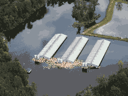 |
| Flooded hog farm |
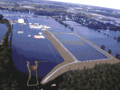 |
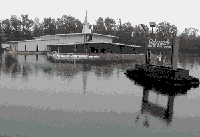
| Wastewater-treatment facility in Greenville, N.C. |
Ammonia concentrations in the Cape Fear River (site 40), Northeast Cape Fear River (site 43), and Lumber River (site 45) ranged from 0.025 mg/L at site 45 to 0.246 mg/L at site 43. The highest ammonia concentration (0.246 mg/L) measured among all of the flood samples (table 6) was in the Northeast Cape Fear River and occurred 6 days following the flood peak. Nitrate concentrations at these three southeast North Carolina sites ranged from 0.015 mg/L at site 45 to 0.330 mg/L at site 40. Median organic nitrogen concentrations at sites 40, 43, and 45 were similar to median flood-sample concentrations measured in the Tar and Neuse Rivers—about 0.7 mg/L—although the maximum concentration in the Northeast Cape Fear River was 1.1 mg/L.
Dissolved organic carbon (DOC) concentrations ranged from 8.4 to 16 mg/L as carbon (C) in the Tar, Neuse, and Cape Fear Rivers, and 17 to 25 mg/L in the carbon-rich, coastal Northeast Cape Fear and Lumber Rivers. These DOC concentrations in floodwaters generally exceeded the highest DOC concentrations previously measured by the USGS in the Tar and Neuse Rivers during the 1990's (table 8).
Floodwaters had two primary effects on nitrogen, phosphorus, and organic carbon. First, floodwaters resulted in tremendous dilution of these constituents. For example, the maximum ammonia concentration at Tarboro (site 14) was 0.051 mg/L on September 21 when the flow was 61,000 ft3/s. If the same mass of ammonia was present at the long-term September mean flow of 1,220 ft3/s, then the ammonia concentration would have been 2.55 mg/L, or a concentration about 10 times greater than was measured during 1990-99 at the site (table 8). Despite this dilution, maximum concentrations of ammonia, organic nitrogen, total phosphorus, and orthophosphorus were similar to 1990-99 median concentrations. Only nitrate levels were low compared to 1990-99 concentrations. The second effect of floodwaters was to export large amounts of organic matter from the floodplains to the streams, as indicated by the high organic nitrogen, DOC, and suspended organic carbon concentrations. The long-term effects of these large loads of organic matter on coastal waters remains to be seen.
NITROGEN AND PHOSPHORUS IN SURFACE WATERSEutrophication of freshwater streams generally results from an excessive amount of phosphorus in the system, whereas excessive nitrogen is most often the cause of eutrophication in estuaries. In order to prevent nuisance plant growth in streams, the U.S. Environmental Protection Agency (USEPA) has established a desired goal of 0.1 mg/L of total phosphorus concentrations in freshwaters not flowing directly into reservoirs or lakes (U.S. Environmental Protection Agency, 1986a), but currently there is no national recommendation for total nitrogen concentrations in either freshwater or coastal systems. The USEPA is leading efforts to develop regional criteria for both phosphorus and nitrogen in surface waters across the Nation. Nitrate is generally the primary form of nitrogen dissolved in water. Ammonia is commonly associated with point sources and is converted to nitrate or nitrogen gas in aerated water. Organic nitrogen, mostly from plant material, can compose a large part of the total (dissolved and particulate) nitrogen concentration in a stream. Total phosphorus in streams consists of phosphates that do not dissolve readily, but are commonly attached to soil particles, and orthophosphates, which are readily dissolved and easily assimilated by aquatic plants. In general, nitrogen and phosphorus concentrations are most elevated in small streams that drain basins with large proportions of urban or agricultural land use (U.S. Geological Survey, 1999). Point-source discharges are a major source of nitrate to the Tar and Neuse Rivers, but ground water is an important source of phosphorus to many streams in eastern North Carolina (Spruill and others, 1998). Nutrient concentrations in streams that drain to the Albemarle and Pamlico Sounds were high relative to 19 other large drainage basins studied by the USGS during 1992-95 (Spruill and others, 1998). |
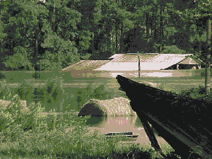 |
| Flooded farm |
Densities of E. coli ranged from 57 to 13,000 cols/100 mL and densities of C. perfringens from 5 to 170 cols/100 mL (fig. 14). The maximum E. coli density occurred in the Neuse River at Fort Barnwell (site 32, fig. 14A). Densities greater than 5,000 cols/100 mL occurred in the Neuse River at Clayton (site 25), Tar River at Louisburg (site 8), and Cape Fear River (site 40). All but the Lumber River and Contentnea Creek had E. coli densities that exceeded the USEPA criterion. Generally, C. perfringens is much less abundant in natural waters than E. coli, and measured densities of C. perfringens were, at most sites, two orders of magnitude less than E. coli. Neuse River sites had somewhat greater densities of C. perfringens than the Tar River sites (fig. 14B), probably reflecting higher point-source dicharges to the Neuse River. Maximum densities of C. perfringens occurred in the Neuse River at Clayton (site 22) and Neuse River at Smithfield (site 23)—both of which are fairly near large municipal wastewater-treatment plant outfalls—and Contentnea Creek (site 31). The lowest densities of C. perfringens occurred in the Northeast Cape Fear and Lumber Rivers, neither of which have large municipal point sources.
|
|
Samples were collected during two or more different streamflow conditions at sites 14, 16, 21, 22, 27, 28, 40, and 43 (table 6). As floodwaters receded, a decrease in E. coli density was observed for Tar River at Tarboro, Neuse River near Clayton and at Smithfield, and Cape Fear River. In the Neuse River near
Goldsboro and the Northeast Cape Fear River, E. coli density was substantially greater in receding floodwaters than near the peak streamflow. Except for the Neuse River at Smithfield, C. perfringens densities did not change substantially as floodwaters receded.
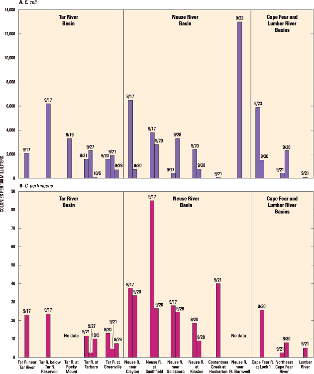 |
| Figure 14. Densities of E. coli and C. perfringens bacteria collected near peak streamflow from Hurricane Floyd flooding, September 17-30, 1999. |
These floodwater densities of E. coli and C. perfringens are some of the first such data collected for either indicator species in North Carolina. As such, these data can be used as a baseline for future results.
WATERBORNE PATHOGENSWaterborne pathogens are bacteria, viruses, and protozoans that cause diseases in humans and are transmitted by drinking or exposure to contaminated water. Waterborne pathogens are found in nearly all surface-water systems, as well as in many ground-water systems, and generally originate from body fluids and feces of humans and animals. Contamination of surface waters by fecal material is a special concern during floods because of failed wastewater-treatment plants, septic systems, and animal waste lagoons. Additional contamination may result where floodwaters innundate vast areas of land that may be contaminated by fecal material from wildlife, livestock, or wastewater spray irrigation systems. The presence of certain types of bacteria are used as indicators of fecal contamination. Water-quality regulations regarding fecal contamination of surface waters in North Carolina are based on the presence of fecal coliform bacteria, which may or may not be of fecal origin. The presence of a specific fecal coliform bacterium, Escherichia coli, is direct evidence of fecal contamination. Another type of bacterial indicator of fecal contamination is fecal streptococci. Enterococci, which is a type of fecal streptococci, is a more specific indicator of contamination than fecal streptococci. Clostridium perfringens is an enteric bacterium that forms a spore which is more tolerant to environmental conditions than other traditional indicators of fecal contamination. C. perfringens is primarily associated with human waste and is resistant to the chlorination process used to disinfect treated wastewater immediately prior to discharge. Consequently, C. perfringens is a useful indicator of fecal contamination from point sources. There are more than 100 types of human waterborne viruses. Bacteriophages (or phages) are viruses that infect bacteria and are present wherever coliform bacteria are present. A coliphage is a virus that specifically infects and replicates in E. coli bacteria; coliphage is considered to be representative of the transport and survival of viruses in the environment. Bacteriodes fragilis phage has been found only in human feces, is unable to multiply in the environment, and is a promising indicator of human fecal pollution. The two most common protozoans implicated in outbreaks of waterborne diseases are Cryptosporidium and Giardia lambia. Cryptosporidium is a parasite that infects many wild and domestic animals, as well as humans, and is highly resistant to disinfectants used to purify drinking water. Giardia is a one-celled, microscopic parasite that lives in the intestines of people and animals. During the past 15 years, Giardia has become recognized as one of the most common causes of waterborne disease in humans in the United States. This parasite is found in every region of the United States and throughout the world, and is moderately resistant to disinfectants. |
Twenty-eight floodwater samples were analyzed for 47
different pesticide compounds by using a broad-spectrum, low-level, solid-phase extraction and gas
chromatography/mass spectrophotometry analytical method (Zaugg and others, 1995). Minimum detection levels for these compounds vary. Of the 47 pesticide compounds, 17 were found in very low but detectable concentrations
ranging from 0.4 to 102 nanograms per liter (ng/L) (table 9). The maximum detected concentration was metolachlor in the Neuse River at Smithfield (site 23). Metolachlor, atrazine, and prometon—all
herbicides—were the pesticides most commonly detected. Metolachlor was detected in every
sample, atrazine in 25 samples, and prometon in 24 samples. Metolachlor, carbaryl (an insecticide used on lawns, fruit trees, and pets), malathion (an insecticide used to control insects on fruits, vegetables, and animals), and diazinon (a residential insecticide) were detected in the greatest concentrations. The largest number of pesticides were detected in Contentnea Creek (site 31), which is a predominantly agricultural basin; 13 pesticides were detected at site 31. A total of 12 pesticide compounds were detected in the Neuse River near Fort Barnwell (site 32). The fewest pesticide compounds were detected in the Tar River near Tar River, where only metolachlor was detected, and the Lumber River where only metolachlor and atrazine were detected.
| Site no. (fig. 13) | Site | Pesticide concentration, in nanograms per liter | |||||||||||||||||
| Date | Alachlor | Atrazine | Butylate | Carbaryl | Chlorpyrifos | Cyanazine | Deethyl atrazine | Diazinon | Malathion | Metolachlor | Napropamide | Pendimethalin | Prometon | Simazine | Tebuthiuron fil | Terbacil | Trifluralin | ||
| 7 | Tar River near Tar River | 9/17 | -- | -- | -- | -- | -- | -- | -- | -- | -- | 11.2 | -- | -- | -- | -- | -- | -- | -- |
| 9/19 | -- | 6.1 | -- | -- | -- | -- | -- | -- | -- | 8.5 | -- | -- | 8.3 | -- | -- | -- | -- | ||
| 8 | Tar River at Louisburg | 9/17 | -- | 7.1 | -- | -- | -- | -- | -- | -- | -- | 9.1 | -- | -- | 13.4 | -- | -- | -- | -- |
| 9/19 | -- | 7.0 | -- | -- | -- | -- | -- | -- | -- | 10.2 | -- | -- | 9.0 | 7.8 | -- | -- | -- | ||
| 9 | Tar River below Tar River Reservoir | 9/17 | -- | 6.9 | -- | 14.1 | 7.9 | -- | -- | -- | -- | 13.4 | -- | -- | 11.9 | -- | -- | -- | -- |
| 9/19 | -- | 5.6 | -- | -- | 5.3 | -- | -- | -- | -- | 12.4 | -- | -- | 8.4 | 8.3 | -- | -- | -- | ||
| 14 | Tar River at Tarboro | 9/21 | -- | 6.8 | -- | 8.8 | 8.6 | -- | -- | -- | -- | 23.2 | -- | -- | -- | -- | -- | -- | -- |
| 9/27 | 8.3 | 6.1 | -- | 4.7 | 2.7 | 7.4 | -- | -- | -- | 26.6 | -- | -- | 6.6 | 5.1 | -- | -- | -- | ||
| 10/5 | -- | -- | -- | -- | -- | -- | -- | -- | -- | 11.4 | -- | -- | 5.8 | -- | -- | -- | -- | ||
| 16 | Tar River at Greenville | 9/21 | 10.8 | 6.0 | -- | 12.7 | 8.0 | 5.2 | -- | 5.9 | -- | 31.9 | -- | -- | 5.8 | 6.0 | -- | -- | -- |
| 9/29 | 8.6 | 9.5 | 7.2 | 6.0 | 5.4 | -- | 2.3 | 3.2 | -- | 35.8 | -- | -- | 6.4 | -- | -- | -- | -- | ||
| 21 | Crabtree Creek at U.S. 1 at Raleigh | 9/16 | -- | 9.7 | -- | 40.8 | -- | -- | -- | 48.2 | -- | 35.7 | -- | -- | 18.3 | 12.1 | -- | -- | -- |
| 22 | Neuse River near Clayton | 9/17 | -- | 7.1 | -- | 47.6 | 9.9 | -- | -- | 29.1 | -- | 73.8 | -- | -- | 16.7 | 12.7 | -- | -- | -- |
| 9/19 | -- | 4.1 | -- | 50.0 | 10.2 | -- | -- | 26.4 | -- | 22.3 | -- | 5.1 | 8.9 | 7.7 | -- | -- | -- | ||
| 9/20 | -- | 7.4 | -- | 22.4 | 9.7 | -- | -- | 25.8 | -- | 22.2 | -- | -- | 11.0 | 10.4 | -- | -- | -- | ||
| 23 | Neuse River at Smithfield | 9/17 | -- | -- | -- | 46.9 | 6.6 | -- | -- | 23.9 | -- | 102 | -- | -- | 15.5 | -- | -- | -- | -- |
| 9/19 | -- | 3.6 | -- | 19.0 | 4.4 | -- | -- | 11.9 | -- | 26.8 | -- | -- | 6.1 | 6.1 | 4.5 | -- | -- | ||
| 9/20 | -- | 7.0 | -- | 17.0 | 7.6 | -- | -- | -- | -- | 22.5 | -- | -- | 10.7 | 8.4 | -- | -- | -- | ||
| 27 | Neuse River near Goldsboro | 9/17 | -- | 16.6 | -- | -- | -- | -- | -- | -- | -- | 25.3 | -- | -- | -- | 12.6 | -- | -- | -- |
| 9/28 | -- | 6.7 | -- | 18.4 | -- | -- | -- | 9.9 | -- | 12.4 | -- | -- | 11.3 | 8.7 | -- | -- | -- | ||
| 28 | Neuse River at Kinston | 9/20 | 10.4 | 10.3 | -- | -- | -- | 8.9 | -- | -- | 51.9 | 22.0 | -- | -- | 13.9 | 8.2 | -- | -- | -- |
| 9/28 | 7.6 | 5.6 | -- | -- | -- | 5.7 | -- | 4.9 | -- | 20.0 | -- | -- | 10.6 | 5.4 | -- | -- | -- | ||
| 31 | Contentnea Creek at Hookerton | 9/21 | 10.3 | 8.8 | 2.5 | 12.0 | 4.9 | 7.9 | -- | 3.5 | -- | 19.1 | -- | -- | 8.7 | 5.7 | 2.2 | 12.2 | 4.7 |
| 32 | Neuse River near Fort Barnwell | 9/22 | 11.7 | 11.2 | 5.2 | 15.3 | 1.8 | 8.1 | -- | 12.2 | 12.5 | 23.6 | -- | -- | 12.6 | 6.3 | -- | -- | 0.4 |
| 40 | Cape Fear River at Lock 1 | 9/23 | -- | 16.5 | -- | 6.0 | -- | -- | 4.9 | 4.4 | 11.2 | 37.5 | -- | -- | 8.0 | 16.0 | -- | -- | -- |
| 9/30 | -- | 33.9 | -- | 6.7 | -- | 4.3 | 6.5 | 8.1 | 4.3 | 28.7 | -- | -- | 15.9 | 4.2 | -- | -- | -- | ||
| 43 | Northeast Cape Fear River near Chinquapin | 9/21 | 8.9 | 6.3 | -- | 12.4 | -- | -- | -- | 4.9 | -- | 30.9 | 5.1 | -- | 2.4 | -- | -- | -- | -- |
| 45 | Lumber River at Boardman | 9/21 | -- | 9.4 | -- | -- | -- | -- | -- | -- | -- | 17.4 | -- | -- | -- | -- | -- | -- | -- |
The highest concentrations of diazinon (an insecticide used to treat lawns and for pest control) was detected in Crabtree Creek, which drains an urban basin, and the Neuse River near Clayton, located immediately downstream from Raleigh. Concentrations of the insecticide carbaryl also were highest at these two sites, as well as the Neuse River at Smithfield. These results are consistent with national findings, which indicate that insecticide concentrations generally are higher in urban streams than in other settings (U.S. Geological Survey, 1999).
Previously collected pesticide data from the Tar River at Tarboro (site 14) and the Neuse River at Kinston (site 28) indicate that detections of metolachlor and atrazine are not uncommon, and that concentrations in floodwaters were somewhat lower than concentrations previously measured under normal flow conditions. For example, in 20 samples collected from the Tar River at Tarboro (site 14) between 1993 and 1994, the median concentration of metolachlor was 36 ng/L and the maximum concentration was 78 ng/L compared to a maximum floodwater concentration of 27 ng/L (table 9). On the other hand, the peak flow at Tarboro was about 50 times greater than the long-term mean September flow, so pesticide concentrations were highly diluted. In the Neuse River at Kinston (site 28), 35 measurements of atrazine during 1994-99 had a median concentration of 20 ng/L and a maximum of 14 ng/L compared to a maximum floodwater concentration of 10.3 ng/L (table 9).
Because of concerns about fuel spills during the flooding that followed Hurricane Floyd, four water samples were collected and analyzed for fuel and fuel oxygenate compounds benzene, diisopropyl ether, ethyl tert-butyl ether (ETBE), ethyl benzene, toluene, xylene, methyl tert-butyl ether (MTBE), and methyl tert-pentyl ether. Three samples were collected from the Tar River at sites 14 (two samples) and 16. A sample also was collected at site 40 on the Cape Fear River. The only compound detected was MTBE at sites 16 (57.8 ng/L) and 40 (36.3 ng/L). However, such limited sampling, in terms of frequency and areal coverage, cannot provide an accurate assessment of the impact of fuel spills on floodwater quality.
 |
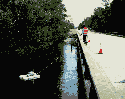
| USGS isokinetic water-quality sampler |
PESTICIDE CONTAMINATION OF SURFACE WATERSTotal annual pesticide use in the United States is about 1 billion pounds (U.S. Geological Survey, 1999), of which about 70 to 80 percent is for agricultural applications. Pesticides include both herbicides, which account for about 60 percent of agricultural pesticides, and insecticides, which are generally more toxic to aquatic life than herbicides. Pesticides, including agricultural pesticides, are detected in all types of settings, including urban areas (for example, Bales and others, 1999), but insecticides are more likely to be detected in high concentrations in urban streams than in other settings (U.S. Geological Survey, 1999). In streams that drain to the Albemarle and Pamlico Sounds, the most commonly detected pesticides in 1993-95 were the herbicides metolachlor, atrazine, alachlor, and prometon (Spruill and others, 1998). The highest concentrations generally occurred in late May and early June; concentrations then decreased throughout the summer. Consequently, if flooding had occurred earlier in the summer, the concentrations of pesticides detected in floodwaters may have been greater than were detected in September. The greatest incidence of pesticide detection during 1993-95 occurred in the Tar River Basin (Spruill and others, 1998). During the 1999 flooding, however, the greatest occurrence of pesticides was in the Neuse River and Contentnea Creek, a major tributary to the Neuse River. Atrazine, carbaryl, metolachlor, diazinon, and malathion were the most commonly detected pesticides in small streams that drain developed areas of Charlotte, which is probably typical of urban areas in eastern North Carolina (Bales and others, 1999). Small streams draining residential areas had the greatest incidence of detection of pesticides in Charlotte. |
 |
| Black River near Tomahawk, N.C. |
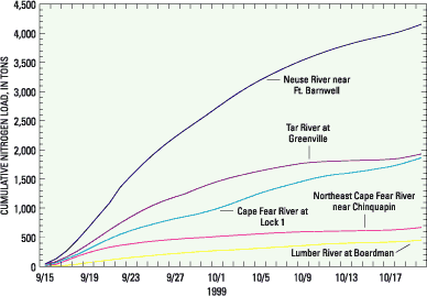
Nitrogen and phosphorus loads were determined at selected locations for September 15-October 20, 1999, by using calculations of mean daily discharge and periodic measurements of concentration. The 36-day period used for the load calculations includes the rise, peak, and fall of floodwaters from Hurricane Floyd. At most sites, subsequent rainfall from Hurricane Irene (October 17-18) caused secondary flooding (for example, figs. 8 and 10) that was not included in these load calculations because concentration data were not collected during this secondary rise. For the Pamlico River at Washington where daily mean discharge data were not available, an estimate of monthly mean discharge for September and October and the median of water-quality data from samples collected by the North Carolina Division of Water Quality during September and October (Larry Ausley, Division of Water Quality, written commun., January 2000) were used to calculate the nitrogen and phosphorus yield for September and October.
|
| Figure 15. Cumulative total nitrogen load at sites near the mouths of the Tar, Neuse, Cape Fear, Northeast Cape Fear, and Lumber Rivers. |
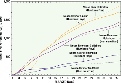
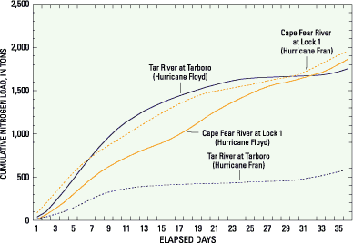
The cumulative load of nitrogen in Hurricane Floyd floodwaters ranged from 450 tons in the Lumber River (site 45) to 4,200 tons in the Neuse River near Fort Barnwell (site 32, fig. 15). At Kinston (site 28), a nitrogen load of about 1,700 tons, equivalent to half of the mean annual nitrogen (3,400 tons; Harned and others, 1995), was carried by Hurricane Floyd floodwaters during this 36-day period (fig. 16). At Tarboro (site 14) almost 80 percent of the mean annual load (2,200 tons; Harned and others, 1995) was transported in Hurricane Floyd floodwaters (fig. 17).
|
| Figure 16. Cumulative total nitrogen load at selected Neuse River sites in floodwaters from Hurricanes Floyd (1999) and Fran (1996). |
One flood sample (table 6) was collected in the Neuse River near Fort Barnwell (site 32), where the highest nitrogen load was estimated to have occurred during flooding (fig. 15). The sample, collected in advance of the peak streamflow on September 22, had a total nitrogen concentration of 1.77 mg/L as N. Two previous measurements of total nitrogen at this site in April and July 1999 under low-flow conditions had concentrations that were similar to the concentration measured in September 1999. The median (1.23 mg/L as N) of these three analyses (April, July, and September) was used as an estimate of concentrations before and after the peak streamflow. This resulted in an estimate of 3,900 tons for the floodwater nitrogen load and a total nitrogen yield of 1.0 tons per square mile (tons/mi2). To determine a maximum load and yield, the concentration measured during the flooding (1.77 mg/L) was used as an estimate of concentration for the entire period, and resulted in an estimated load of 5,400 tons and a yield of 1.4 tons/mi2. A conservative estimate of nitrogen concentration is based on the minimum concentration (1.11 mg/L as N on April 21, 1999) previously measured at Fort Barnwell, and results in a load of about 3,500 tons and a yield of 0.9 tons/mi2.
|
| Figure 17. Cumluative total nitrogen load at selected Tar and Cape Fear River sites in floodwaters from Hurricanes Floyd (1999) and Fran (1996). |
The total load of nitrogen carried in Hurricane Floyd floodwaters was quite similar to the total load carried by Hurricane Fran floodwaters in the Neuse River (fig. 16) and the Tar and Cape Fear Rivers (fig. 17)—despite the greater total streamflow resulting from Hurricane Floyd. Nitrogen concentrations generally were less in Hurricane Floyd floodwaters than following Hurricane Fran (Bales and Childress, 1996). In the Tar River Basin, where the Hurricane Floyd peak discharge was more than three times that from Hurricane Fran, nitrogen load at site 14 was 1,800 tons in Hurricane Floyd floodwaters compared to 590 tons in Hurricane Fran floodwaters.
|
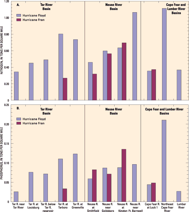
| Figure 18. (A)Nitrogen and (B)phosphorus yields at selected sites in floodwaters from Hurricanes Floyd (1999) and Fran (1996). |
For the period September 15 to October 20, total nitrogen yield in basins upstream from the sampled sites ranged from 0.34 to 1.1 tons/mi2 (fig. 18A). Although the total nitrogen load was much smaller for the Northeast Cape Fear River (site 43) than for the Neuse River near Fort Barnwell (site 32—the site with the greatest total nitrogen load; fig. 15), the yield for the two basins was approximately the same (fig. 18A). The yield for the Pamlico River at Washington (site 18) was calculated, based on monthly data, at 0.81 tons/mi2 in September and 0.28 tons/mi2 in October. Nitrogen yields resulting from Hurricane Floyd were similar to those resulting from Hurricane Fran in the Neuse and Cape Fear Basins (fig. 18A). However, the nitrogen yield for the Tar River at Tarboro (site 14) was 0.80 tons/mi2 in Hurricane Floyd floodwaters compared to 0.27 tons/mi2 in floodwaters from Hurricane Fran, which is a result of much more widespread flooding in the Tar River Basin after Hurricane Floyd than after Hurricane Fran.
|
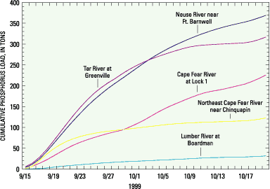
| Figure 19. Cumulative total phosphorus load at sites near the mouths of the Tar, Neuse, Cape Fear, Northeast Cape Fear, and Lumber Rivers. |
Phosphorus loads for September 15 to October 20 ranged from 30 tons in the Lumber River (site 45) to 370 tons in the Neuse River near Fort Barnwell (site 32; fig. 19). The estimated phosphorus load at Kinston (site 28) was 66 percent of the mean annual phosphorus load of 350 tons (Harned and others, 1995). The estimated load during flooding at Tarboro (site 14) was 89 percent of the mean annual load of 270 tons (Harned and others, 1995). Phosphorus yields ranged from 0.03 to 0.21 tons/mi2 (fig. 18B). The lowest yield was in the Lumber River Basin (site 45), and the highest yield was in the Northeast Cape Fear River (site 43). The yield was 0.19 tons/mi2 for the Tar-Pamlico River Basin above Washington (site 18); this estimate was for September based on the monthly average discharge and the median concentration). Although the Neuse River near Fort Barnwell (site 32) carried a greater total phosphorus load (fig.19), the Northeast Cape Fear had a greater yield (fig. 18B). In the Neuse and Cape Fear River Basins, total phosphorus yields resulting from Hurricane Floyd were generally slightly less than those resulting from Hurricane Fran. In the Tar River Basin, however, the phosphorus yield resulting from Hurricane Floyd was nearly triple that from Hurricane Fran. The concentration of phosphorus was similar, but the quantity of streamflow that resulted from Hurricane Floyd was much greater.
As previously discussed, residence time in the Pamlico River and Neuse River estuaries was greatly reduced during the flooding. Consequently, nutrients and organic matter that are typically biochemically transformed or settle in these systems likely passed directly through the estuaries to Pamlico Sound. The effects of this massive pulse of nitrogen, phosphorus, and organic carbon on the Pamlico Sound ecosystem remains to be seen.
|
|
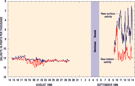 |
| Figure 20. Near-surface and near-bottom salinity measured at Pamlico River at Light 5 (site 46, fig. 7) during August-September 1999. |
Floodwaters entering the Pamlico and Neuse River estuaries flushed brackish water out of the estuaries. High flows associated with Hurricane Dennis resulted in increased stratification and decreased salinity in the Pamlico River estuary (fig. 20). Following Hurricane Floyd, there was little salt in much of the Pamlico River (fig.21). Near-surface salinity remained less than 2 parts per thousand (ppt) in December 1999, whereas salinity at this location typically ranges from 7 to 11 ppt during October to November (Bales and Robbins, 1995). As late as January 2000, near-surface salinity at site 46 remained about 1 ppt, and near-bottom salinity was about 5-7 ppt, demonstrating the continued effect of the high volume of freshwater discharged to the estuary. The effects of the flooding on salinity seem to be more extreme in the Neuse River estuary. Both near-surface and near-bottom salinity in the Neuse River remained less than 2 ppt in January 2000 as far downstream as Cherry Point, where the estuary makes a 90-degree bend from the southeast to the northeast (fig. 7).
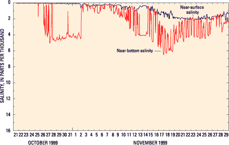 |
| Figure 21. Near-surface and near-bottom salinity measured at Pamlico River at Light 5 (site 46, fig. 7) during October-November 1999. |
Hurricane floodwaters also affected dissolved oxygen concentrations in the estuaries, although persistent and extremely low dissolved oxygen conditions were not observed. Prior to Hurricane Dennis, dissolved oxygen in the Neuse River at New Bern (site 47, fig. 7) was near zero at the bottom, but was between 8 and 10 mg/L near the water surface. Following Hurricane Floyd, the water column was mixed, with only a small difference between near-surface and near-bottom dissolved oxygen (fig. 22). Dissolved oxygen gradually recovered during October, but was generally between 4 and 6 mg/L, which is somewhat low for fall conditions. Dissolved oxygen concentrations increased with distance downstream from New Bern during September and October. Dissolved oxygen concentrations generally were greater than 6 mg/L in the Pamlico River estuary during September and October, except near Washington, where dis- solved oxygen increased from about 2 mg/L in late September to 6 mg/L by about mid-October.
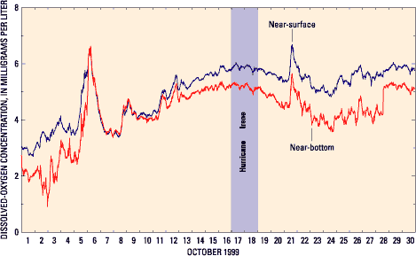 |
| Figure 22. Near-surface and near-bottom dissolved oxygen concentration at Neuse River at Marker 38 (site 47, fig. 7) at New Bern, October 1999. |
|
| ||||
|
Return to the |
|