
|
Two Months of Flooding in Eastern North Carolina, September - October 1999: Hydrologic Water-Quality, and Geologic Effects of Hurricanes Dennis, Floyd, and IreneWater-Resources Investigations Report 00-4093
|
During most of 1999 prior to September, almost the entire State of North Carolina was in a drought condition. The rainfall deficit (based on 1960-90 monthly averages) for the 12 months preceding September 1999 was
9.31 inches at Asheville,
10.41 inches at Charlotte,
5.27 inches at Greensboro,
6.39 inches at Raleigh,
13.0 inches at Kinston, and
2.75 inches at Wilmington
(National Climatic Data Center 1998, 1999; State Climate Office of North Carolina, 1999b). As a result, some restrictions on water use had been implemented at numerous locations around the State.
Hurricanes Dennis, Floyd, and Irene occurred within a 6-week period between September 4 and October 17, 1999. All three storms brought extremely heavy and, in some cases, unprecedented rainfall to eastern North Carolina. Rocky Mount, located in the central part of the Tar-Pamlico Basin, received 37.72 inches of rain during September-October, or about 85 percent of the average annual rainfall for that location (table 1). Kinston, in the Neuse River Basin, received 29.48 inches of rain during the same period, and more than half of the average annual rainfall fell during September alone. Most reporting stations in the central and western Coastal Plain received at least half the average annual rainfall during September - October (table 1).
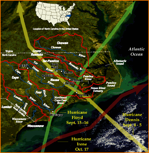 |
| Figure 2. Satellite image of eastern North Carolina with generalized basin outlines and tracks for Hurricanes Dennis, Floyd, and Irene, September-October 1999. (Satellite image from National Aeronautics and Space Administration, 1999.) Flooding along selected rivers, such as the Tar, Neuse, and Waccamaw, can be seen, as well as sediment plumes in Albemarle Sound and the Pamlico River. |
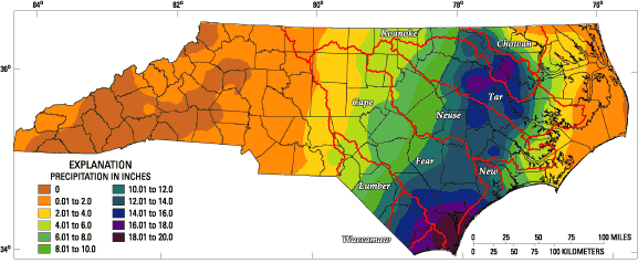
Hurricane Dennis followed an unusual path, approaching the coast, retreating to about 150 miles offshore, meandering offshore for several days, approaching the shore again, and eventually moving across North Carolina during September 4-5 in a west-northwesterly direction over the Neuse and Tar-Pamlico River Basins (fig.2). Rainfall amounts were generally greatest near the coast, but exceeded 7 inches in much of the central Neuse and Tar-Pamlico River Basins (table 1; fig. 3).
Hurricane Floyd made landfall near Cape Fear on September 15 with the center of the storm traveling to the east of Wilmington (fig. 2). The storm moved in a north-northeasterly direction over the lower Cape Fear, Neuse, Tar-Pamlico, lower Roanoke, and Chowan River Basins. The storm delivered 12 to 18 inches of rain to much of the Neuse and Tar-Pamlico River Basins (table 1; fig. 4), triggering regional flooding that continued throughout the remainder of September and most of October.
Hurricane Irene never made landfall in North Carolina, but moved in a northeasterly direction just east of the coastline on October 17 (fig. 2). However, rainfall amounts associated with Hurricane Irene exceeded 5 inches in the eastern part of the Neuse Basin and in the central and eastern Tar-Pamlico Basin (table 1). The additional rainfall from Hurricane Irene coupled with the already-saturated soil and elevated river levels ensured that the Tar and Neuse Rivers remained above National Weather Service (NWS) flood stage throughout most of September and October.
Extremely large rain events are characterized by (1) the duration of the rain event, (2) the magnitude of the rainfall for a selected duration, and (3) the recurrence interval, or the chance that a rain event of a specified duration and magnitude will occur in any particular year. The 100-year, 12-hour rainfall for eastern North Carolina is between 7 and 8 inches (Hershfield, 1961). This means that a rain event that lasts 12 consecutive hours and delivers at least between 7 and 8 inches of rainfall has a 1-percent chance of occurring during any given year in eastern North Carolina. Likewise, the 100-year, 24-hour rainfall for eastern North Carolina is between 8 and 9 inches (Hershfield, 1961). Rainfall amounts associated with more rare events (for example, 500-year storms) have not been established for most locations in the United States.
 |
| Figure 3. Rainfall in North Carolina, September 4-5, 1999, during passage of Hurricane Dennis and locations of selected raingages in eastern North Carolina. (Rainfall map from State Climate Office of North Carolina, 1999c.) |
 |
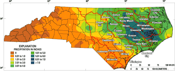
| Figure 4. Rainfall in North Carolina, September 14-16, 1999, prior to and during the passage of Hurricane Floyd. (Rainfall map from State Climate Office of North Carolina, 1999d.) |
The greatest consecutive 12-hour rainfall at Kinston during Hurricane Floyd was approximately equal to the 100-year rain event, but the greatest 12-hour rainfall at Rocky Mount exceeded the 100-year rainfall (table 2). At both Kinston and Rocky Mount, the greatest 24-hour rainfall during Hurricane Floyd far exceeded the 100-year rainfall (table 2); at Rocky Mount, the measured 24-hour rainfall was almost double the statistically derived 100-year rainfall. Consequently, from a statistical perspective the rainfall associated with Hurricane Floyd was extremely unusual with a very low probability of occurrence.
| Location (fig.3) | Rainfall, in inches | |||
| Maximum 12-hour (observed) | a100-year, 12-hour | Maximum 24-hour (observed) | a100-year, 24-hour | |
| Rocky Mount | 10.38 | 7-8 | 14.73 | 8-9 |
| Kinston | 7.90 | 7-8 | 12.54 | 8-9 |
| aStatistics from Hershfield (1961). | ||||
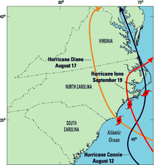 |
| Figure 5. Generalized tracks of Hurricanes Connie, Diane, and Ione, August-September 1955. |
The 1999 hurricane season in North Carolina has been compared with the 1955 season, when three hurricanes made landfall in the State during a 5-week period between August 12 and September 19 (figs. 1, 5). Rainfall amounts during August-September 1955 (National Climatic Data Center, 1955a,b) were, for some locations, greater than rainfall amounts during September-October 1999. For example, Maysville, which is located in Onslow County near the current raingage at Hoffman Forest (fig. 3), received 50.26 inches during August-September 1955. Kinston (fig. 3) received 29.89 inches during the same period, or about the same amount of rainfall as during September-October 1999. Maysville, Morehead City, Oriental, and New Bern all reported monthly rainfall in excess of 20 inches for both August and September 1955.
For most of eastern North Carolina, however, monthly rainfall was generally much greater in September 1999 than in August 1955-both months during which two hurricanes made landfall in North Carolina (fig. 6). Rainfall throughout most of the Tar-Pamlico River Basin was two to three times greater in September 1999 than in August 1955 (fig. 6). Likewise, rainfall in the upper and middle Neuse River Basin was almost two times greater in September 1999 than in August 1955 (fig. 6). Only in the extreme eastern part of the State did August 1955 rainfall exceed September 1999 rainfall. The heaviest rainfall was more widespread in September 1999 than in August 1955, and fell over parts of the river basins that are more susceptible to flooding.
|
|
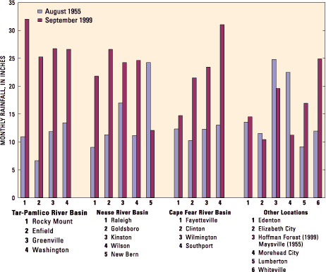 |
| Figure 6. August 1955 and September 1999 monthly rainfall at selected sites in the Tar-Pamlico, Neuse, and Cape Fear River Basins, and at selected other sites. |
Hurricane Fran in September 1996 resulted in extensive flooding in many of the same areas affected by Hurricane Floyd (Bales and Childress, 1996). Flood recurrence intervals were in excess of 100 years at a number of locations in the upper Tar-Pamlico Basin, upper Neuse Basin, and throughout much of the Cape Fear River Basin.
Rainfall amounts associated with Hurricane Fran were greater than those of Hurricane Floyd in the upper Tar (Oxford) and upper Neuse (Durham and Raleigh) River Basins (table 1). Hurricane Fran rainfall also was greater than Hurricane Floyd rainfall in the upper Cape Fear River Basin (Chapel Hill, table 1), including the Haw and Deep River Basins, where Hurricane Fran flood recurrence intervals were generally between 100 and 500 years. In addition, Hurricane Fran rainfall exceeded Hurricane Floyd rainfall near the coast at Morehead City and Hoffman Forest (table 1). However, with these few exceptions, Hurricane Floyd rainfall was much greater than rainfall from Hurricane Fran. For example, at Rocky Mount and Kinston, Hurricane Floyd rainfall was almost three times greater than Hurricane Fran rainfall (table 1). The highest reported consecutive 24-hour rainfall associated with Hurricane Fran was 6.70 inches at Franklinton (National Climatic Data Center, 1996b), which is about 10 miles west of Louisburg (fig. 3). This rainfall amount corresponds to approximately a 24-hour 25-year rainfall event, compared to Hurricane Floyd rainfall, which was much greater than a 24-hour 100-year rainfall event (table 2).
As a general rule, it should not be assumed that a 100-year rain event would result in a 100-year flood. Conditions prior to a particular storm affect the amount of runoff that occurs during the storm. Dry soil allows more infiltration of rainfall and less runoff, whereas wet soil results in more runoff for the same amount of rainfall. The soaking rains from Hurricane Dennis (table 1) that fell over a wide area of eastern North Carolina immediately prior to Hurricane Floyd resulted in wet soils capable of storing little additional water.
|
|
Another factor that affects the relation of a particular rain event to the potential for flooding is the spatial extent and duration of the rainfall relative to the watershed size. An intense, localized thunderstorm may result in 100-year rainfall over part of a basin but little rainfall over the remainder of the watershed, resulting in minimal downstream flooding. Moreover, a 100-year, 1-hour storm on a 1-square-mile (mi2) basin will more likely result in severe flooding in that basin than the same event on a 1,000-mi2 basin; longer duration storms generally are required to produce flooding in large river basins. Consequently, the wet soils caused by Hurricane Dennis, the broad regional coverage of rainfall from Hurricane Floyd (table 1; fig. 4), and the long duration of the rainfall combined with the large rainfall amounts (table 2) ensured that unprecedented regional flooding would occur in eastern North Carolina in response to these storms.
|
|
Return to the |
|