|
Two Months of Flooding in Eastern North Carolina, September - October 1999: Hydrologic Water-Quality, and Geologic Effects of Hurricanes Dennis, Floyd, and IreneWater-Resources Investigations Report 00-4093
|
Events in 1999 continued a pattern that began in 1996 with greater-than-normal tropical cyclone activity in North Carolina. Between 1886 and 1999, one tropical cyclone made landfall in North Carolina on average once every 3.4 years, and between 1961 and 1995, only six tropical cyclones made landfall in the State. However, between 1996 and 1999, six additional tropical cyclones made landfall in North Carolina, and several others (for example Jerry in 1997 and Irene in 1999) substantially affected the State. The combined effects of Hurricanes Dennis, Floyd, and Irene in September and October 1999 resulted in almost 2 months of flooding throughout most of eastern North Carolina. Hurricane Floyd will likely be the second or third most costly hurricane to strike the United States in the 20th century and resulted in more fatalities than any hurricane to strike the United States since 1972, including 52 fatalities in North Carolina. Rainfall amounts recorded during Hurricane Floyd (September 14-17, 1999) and accumulated during the months of September and October were unprecedented for many parts of eastern North Carolina during more than 80 years of precipitation records. Flooding was at record levels, and 500-year or greater floods occurred in all of the State's river basins east of Raleigh, with the exception of the Lumber River Basin.
|
|
Some of the most widespread flooding occurred in the Tar-Pamlico River Basin downstream from Louisburg. Measured flood flows on the Tar River and major tributaries downstream from the Tar River Reservoir near Rocky Mount had recurrence intervals in excess of 100 years, and several sites had recurrence intervals in excess of 500 years. At Tarboro, where streamflow records have been collected since 1897, the peak stage during this event was almost 10 feet higher than the previously recorded peak stage. Flood recurrence intervals in many of the tributaries to the Neuse River downstream from Clayton were in excess of 500 years, but flood recurrence intervals along the mainstem of the Neuse were between 25 and 50 years, although the Neuse River at Kinston was above flood stage all of October. Floods having recurrence intervals near or in excess of 500 years also occurred on the Cashie River and Ahoskie and Potecasi Creeks in northeast North Carolina; and on the New, Northeast Cape Fear, Black, and Waccamaw Rivers in southeast North Carolina.
As a result of the flooding, the total freshwater inflow volume to Pamlico Sound during September- October was equivalent to about 83 percent of the total volume of the Sound, whereas under normal conditions, inflow volume during these 2 months is equivalent to about 13 percent of the volume of the Sound. This means that by the end of October, much of the water that was in the Sound at the beginning of September could have been displaced by floodwaters. Estimated mean water residence time was about 7 days for the Pamlico River and Neuse River estuaries during September compared to a long-term annual average of 72 and 68 days, respectively, for these estuaries. Consequently, material that might normally be deposited or biochemically transformed in the estuaries was transported into Pamlico Sound.
The cumulative load of nitrogen in Hurricane Floyd floodwaters during September 15-October 20 ranged from 450 tons in the Lumber River to 4,200 tons in the Neuse River near Fort Barnwell. The mean annual nitrogen in the Neuse River at Kinston is about 3,400 tons; about half of this load was carried by Hurricane Floyd floodwaters during this 36-day period. In the Tar River at Tarboro, almost 80 percent of the mean annual nitrogen load of 2,200 tons was transported in Hurricane Floyd floodwaters. The total load of nitrogen carried in Hurricane Floyd floodwaters was quite similar to the total load carried by Hurricane Fran floodwaters in the Neuse, Tar, and Cape Fear Rivers, despite the generally greater total streamflow resulting from Hurricane Floyd. During the same period, phosphorus loads ranged from 30 tons in the Cape Fear River to 370 tons in the Neuse River near Fort Barnwell. The estimated phosphorus load in the Neuse River at Kinston was 66 percent of the mean annual phosphorus load of 350 tons, and the estimated phosphorus load during flooding in the Tar River at Tarboro was 89 percent of the mean annual load of 270 tons.
|
|
Of the 47 different pesticide compounds analyzed, 17 were detected in floodwaters at concentrations ranging from 0.4 to 102 nanograms per liter. The highest pesticide concentration detected was metolachlor in the Neuse River at Smithfield. Metolachlor, prometon, atrazine, and carbaryl were the compounds most commonly detected, and metolachlor and carbaryl were detected in the greatest concentrations. The greatest number of pesticide compounds were detected in the Neuse River near Fort Barnwell.
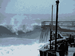
Although winds from Hurricane Dennis were not particularly strong, the storm meandered about 150 miles off the coast of the northern Outer Banks for nearly a week, generating large waves that pounded the coast. As a result, erosion of dunes between Cape Hatteras and Oregon Inlet was highly variable; in some areas, dunes retreated more than 100 feet, whereas in other areas the dunes were stable. The effects of Hurricane Floyd on shoreline erosion and dune retreat seem to have been greater than the effects of Hurricane Bonnie, a 1998 Category 3 storm that made landfall in the same area as Hurricane Floyd.
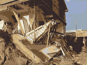
Hurricanes and floods are complex natural events that occur with some regularity in North Carolina, as well as in many locations around the world. These natural events become natural disasters when people and property are located in positions vulnerable to the destructive effects of these events. As the population increases in eastern North Carolina, there is an increasing possibility that natural events will result in more costly and more deadly natural disasters (Barton and Nishenko, 1994). The lessons learned as a result of the hurricanes and floods of 1999 can be used to guide rebuilding and mitigation of the effects of future hurricanes and floods in North Carolina.
Return to the |
|