U.S. Geological Survey Data Series 74, Version 3.0
By Bradford Butman1, P. Soupy Dalyander2, Michael H. Bothner1, Jonathan Borden1, Michael A. Casso1, Benjamin T. Gutierrez3, Mary E. Hastings1, Frances L. Lightsom1, Marinna A. Martini1, Ellyn T. Montgomery1, Richard R. Rendigs1, and William S. Strahle1 Published 2009 Abstract
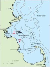
This data report presents long-term oceanographic observations made in western Massachusetts Bay at long-term site A (LT-A) (42° 22.6' N., 70° 47.0' W.; nominal water depth 32 meters) from December 1989 through February 2006 and long-term site B (LT-B) (42° 9.8' N., 70° 38.4' W.; nominal water depth 22 meters) from October 1997 through February 2004 (fig. 1). The observations were collected as part of a U.S. Geological Survey (USGS) study designed to understand the transport and long-term fate of sediments and associated contaminants in Massachusetts Bay. The observations include time-series measurements of current, temperature, salinity, light transmission, pressure, oxygen, fluorescence, and sediment-trapping rate. About 160 separate mooring or tripod deployments were made on about 90 research cruises to collect these long-term observations. This report presents a description of the 16-year field program and the instrumentation used to make the measurements, an overview of the data set, more than 2,500 pages of statistics and plots that summarize the data, and the digital data in Network Common Data Form (NetCDF) format. This research was conducted by the USGS in cooperation with the Massachusetts Water Resources Authority and the U.S. Coast Guard. Citation: Butman, Bradford, Dalyander, P.S., Bothner, M.H., Borden, Jonathan, Casso, M.A., Gutierrez, B.T., Hastings, M.E., Lightsom, F.L., Martini, M.A., Montgomery, E.T, Rendigs, R.R., and Strahle, W.S., 2009, Long-term oceanographic observations in Massachusetts Bay, 1989–2006: U.S. Geological Survey Data Series 74, v. 3.0, DVD-ROM. Also available online at https://pubs.usgs.gov/ds/74/. 1U.S. Geological Survey, Woods Hole Science Center, Woods Hole, MA 02543 Note: This Version of Data Series 74 (Version 3) supersedes Version 2.
DisclaimerAny use of brand, trade, or firm names is for descriptive purposes only and does not imply endorsement by the U.S. Government. |

![]() U.S. Department of the Interior |
U.S. Geological Survey
U.S. Department of the Interior |
U.S. Geological Survey
URL: http://pubsdata.usgs.gov/pubs/ds/74/index.html
Page Contact Information: Contact USGS
Page Last Modified: Monday, 28-Nov-2016 13:53:02 EST
![]()