|
Multibeam Bathymetric and Backscatter Maps of the Upper Hudson Shelf Valley and Adjacent Shelf, Offshore of New York
One of the most striking aspects of the sea floor shown by this survey is the variability in backscatter intensity and bottom morphology over scales of a few kilometers or less caused by both natural and anthropogenic processes. The topography, surface features, and the surficial sediments have been heavily influenced by the disposal of dredged and other material in this region over the last century (summarized in Williams, 1979).
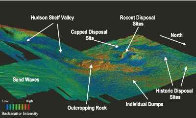 |
Figure 3. Perspective view of the northern portion of the survey region showing sea floor topography and sediment backscatter, looking southwest and across the shelf and toward the head of the Hudson Shelf Valley. This image was created by vertically exaggerating the bathymetry (in this case 20 times), artificially shading the relief (by artificially illuminating the relief, in this case from the north), and then draping the color-coded backscatter intensity over the bathymetry. Within each backscatter color (red is high backscatter, blue is low backscatter), the intensity varies from dark to light depending on the sun illumination. High backscatter generally indicates a hard bottom, such as coarse-grained sediments or rock; weak backscatter indicates a soft, non-reflective bottom, such as fine-grained sediments. The vertical exaggeration accentuates the small-scale variability of the bathymetry (relief of a few meters) that would be difficult to show in a traditional contour map. Features include: relatively smooth topographical highs composed of material dumped since the 1800's; mounds (as high as 10m) of dredged material from more recent disposal; a smooth, roughly circular region resulting from disposal of contaminated sediments and capping with course sand; outcrops of southeastward-dipping coastal plain strata at the head of the Hudson Shelf Valley of probable cretaceous-age; low-relief (amplitude <1m) sand waves suggesting sediment transport to the Southwest; individual features that are interpreted to be dumps of material, some arrange in lines, which are probably rocks; low-backscatter, smooth sediment extending to the east from the region of recent disposal; low backscatter fine-grained sediments in the axis of the Hudson Shelf Valley.
 |
Based on Butman, B., Danforth, W.W., Schwab, W.C., and Buchholtz ten Brink, M.B., 1998, Multibeam Bathymetric and Backscatter Maps of the Upper Hudson Shelf Valley and Adjacent Shelf, Offshore of New York: U.S. Geological Survey Open-File Report 98-616. |
Web page by: Donna Newman
[an error occurred while processing this directive]
|
|