U.S. Geological Survey Open-File Report 2009-1001
Geological Interpretation of the Sea Floor Offshore of Edgartown, Massachusetts
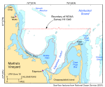
The imagery, digital terrain models (DTMs), interpretive data layers, and supplemental data presented herein were derived from sidescan-sonar and multibeam and single-beam echo-sounder data collected in the vicinity of Edgartown Harbor, a main port and anchorage on Martha's Vineyard, Massachusetts, and from the seismic-reflection profiles and stations occupied to verify these acoustic data (fig. 1). Basic data layers show backscatter intensity, sea-floor topography, and sun-illuminated shaded relief; interpretive layers show the distributions of sea-floor features and buried channels of a late Pleistocene drainage system. Presented supplemental and verification data include Boomer and Chirp seismic-reflection profiles, sediment grain-size analyses, and a gallery of still photographs of the seabed. The sidescan-sonar and shallow-water multibeam data, which together cover approximately 37.3 km² of sea floor, were collected during 2004 as part of National Oceanic and Atmospheric Administration (NOAA) hydrographic survey H11346 (figs. 1, 2). Although originally collected for charting purposes, these data provide a fundamental framework for research and management activities along this part of the Massachusetts coastline (Noji and others, 2004), show the composition and terrain of the seabed, and provide information on sediment transport and benthic habitat. This publication is the fifth in a series of digital reports describing the sea-floor geology around Cape Cod. The first focused on the area off the eastern shore of the outer Cape (Poppe and others, 2006); the second on Quicks Hole, a passage through the Elizabeth Islands (Poppe and others, 2007a); the third on Great Round Shoal Channel at the eastern entrance to Nantucket Sound (Poppe and others, 2007b); and the fourth on Woods Hole, a passage between Cape Cod and the Elizabeth Islands (Poppe and others, 2008). |

![]() U.S. Department of the Interior |
U.S. Geological Survey
U.S. Department of the Interior |
U.S. Geological Survey
URL: https://pubsdata.usgs.gov/pubs/of/2009/1001/html/intro.html
Page Contact Information: Contact USGS
Page Last Modified: Wednesday, 07-Dec-2016 22:23:35 EST