U.S. Geological Survey Open-File Report 2009-1001
Geological Interpretation of the Sea Floor Offshore of Edgartown, Massachusetts
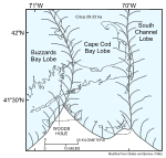
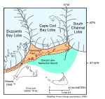
The configuration and geology of Nantucket Sound, Cape Cod, and the adjacent islands are products of glacial processes during the late Pleistocene and a storm- and tide-dominated marine regime during the Holocene sea-level rise. The late Wisconsinan Laurentide ice sheet reached its maximum extent and southernmost position about 20 to 22 thousand years ago, as marked by terminal moraines on Block Island, Martha's Vineyard, and Nantucket and the southern limit of abundant gravel on the intervening sea floor (Schlee and Pratt, 1970; Oldale and O'Hara, 1984; Uchupi and others, 1996; fig. 3). This lobate ice front was formed by the Buzzards Bay lobe that deposited the moraine along the western part of Martha's Vineyard, the Cape Cod Bay lobe that deposited the moraines across eastern Martha's Vineyard and Nantucket, and the South Channel lobe that extended east toward Georges Bank (Oldale and Barlow, 1986; Oldale, 2001). Shortly before 18 thousand years ago, the ice sheet had retreated, and the Buzzards Bay lobe occupied a position along the Elizabeth Islands. The Cape Cod Bay lobe was along the northern edge of Cape Cod, and the South Channel lobe was adjacent to the Cape Cod Bay lobe (Larson, 1982; Uchupi and others, 1996; fig. 4). About this time, meltwaters from the Cape Cod bay lobe were dammed by the terminal moraine, forming a large proglacial lake in Nantucket Sound, and the main part of Cape Cod, the Barnstable outwash plain, was built by a delta prograding into this proglacial lake. Subsequent collapse of the dam allowed the proglacial lake to drain, exposing the lake-floor sediments to subaerial erosion. During this time and prior to sea-level rise, the glacial drift beneath the study area was eroded by streams that flowed northeastward toward the dendritic fluvial system that drains the area beneath present day Nantucket Sound (O'Hara and Oldale, 1987; Oldale, 2001; Uchupi and Mulligan, 2006). Initially during Holocene submergence, the postglacial valleys were partly filled by estuarine, marsh, and other transitional deposits (Gutierrez and others, 2003). Eventually, the transgressing seas covered, reworked, and smoothed the sea floor and marine sediments accumulated over the wave-cut surface. Shallow stratigraphy interpreted from high-resolution seismic profiles, collected as part of this and an earlier study (O'Hara and Oldale, 1987), reflects this Quaternary history. Strong tidal currents in Nantucket Sound are driven by the different filling and flushing rates and sizes of the adjacent water bodies. For example, the ebb tide off East Chop flows west and exceeds 2.1 kts (1.08 m/s); the flood tide adjacent to Cape Poge flows north and exceeds 2.2 kts (1.13 m/s) (Eldridge-White and Foster-White, 2008). Although the nearshore parts of the survey area are partially protected, they are shallow and above wave base. |

![]() U.S. Department of the Interior |
U.S. Geological Survey
U.S. Department of the Interior |
U.S. Geological Survey
URL: https://pubsdata.usgs.gov/pubs/of/2009/1001/html/setting.html
Page Contact Information: Contact USGS
Page Last Modified: Wednesday, 07-Dec-2016 22:23:40 EST