U.S. Geological Survey Open-File Report 2009-1001
Geological Interpretation of the Sea Floor Offshore of Edgartown, Massachusetts
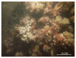
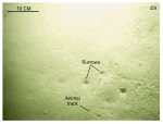
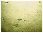
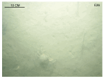
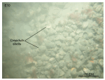
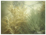
Sediment Distribution Gravel and gravelly sand are in the study area along exposed shorelines, such as off Cape Poge and at the tip of the elongated bathymetric high that extends northeastward from Middle Flats, where scattered boulders were also observed in the bottom video (fig. 29). These are shallow, high-energy areas characterized by sedimentary processes associated with erosion and nondeposition. The Holocene section in these areas is thin or absent, suggesting that finer grained sediments have been winnowed away leaving coarser lag deposits. Boulders, where present, are typically covered by sessile flora and fauna (fig. 30). Sand is the dominant textural class of the sediment along the more protected shorelines, such as off Edgartown Beach, along the flanks of the elongated bathymetric high that extends northeastward from Middle Flats, and in the offshore parts of the study area in Nantucket Sound. Medium and fine-grained sand dominates the more protected areas (for example, stations E5 and E7) and the deeper waters offshore (for example, stations E9 and E31). The sea floor in the offshore sandy areas is typically flat or only faintly rippled and burrowed (figs. 31, 32). Coarse and very coarse sand dominate bathymetric highs (for example, station E17) and exposed offshore areas (for example, stations E34 and E35). Sorting of the sandy sediments is generally poor, but improves on bathymetric highs and off Cape Poge, where tidal- and wave-driven currents rework the sediments. Finer grained sediments are limited to deeper, more protected areas. Patches of silty sand are both east and west of the elongated bathymetric high that extends northeastward from Middle Flats. The finest grained sediment is clayey silt, which dominates in Edgartown Harbor where low-energy conditions characterized by sedimentary processes associated with deposition prevail (fig. 33). Shell beds are common in the offshore part of the study area (fig. 21). Tidal and wave currents there are strong enough to sweep the shells off bathymetric highs, such as the seaward extension of Middle Flats, and to hydraulically concentrate the shells in adjacent, more protected bathymetric lows, notably at stations E16 and E22 (figs. 34, 35, 36). These beds are typically thin and presumably ephemeral. Although mussel, scallop, and whelk shells locally constitute a significant portion of the shell debris, the densest beds are composed predominantly of slippersnail (Crepidula) shells. These shell beds are ecologically important because they form sea-floor habitats of rough, relatively hard substrates that add considerably to the overall benthic compositional complexity. Bottom photography shows that infauna construct burrows in the shell deposits, juvenile finfish shelter between the shells, and sessile fauna and flora attach themselves to the hard substrate provided by the shells. Dense beds of seaweed are on the crest and upper flanks of the seaward extension of Middle Flats (figs. 37, 38). Conditions on this bathymetric high are probably favorable for seaweed growth because the coarser sediments there provide a more stable substrate, and because the shallow depths and lower turbidity, owing to the offshore location, permit greater light penetration. Elsewhere, bottom photography reveals that mats of dead drifting seaweed collect in lower energy depressions and that pebbles with attached seaweed are dragged along in the tidal currents. These seaweed beds are ecologically important because they also add dramatically to the overall benthic roughness. Sediment Data The sediment grain-size dataset provided here contains information on the collection, location, description, and texture of sediments at 37 stations occupied during the 2008 RV Rafael verification cruise 08012 (figs. 15, 29). All analyses were conducted in the sedimentation laboratory at the USGS Woods Hole Coastal and Marine Science Center. Records without textural data and statistics are based on visual descriptions. The basic structure of the data is a flat-file format, a matrix where records are rows representing individual samples and the columns contain sample- and station-specific information. This matrix consists of 42 fields which are defined in the Data Dictionary below. The sediment data are provided in two formats: Microsoft Excel and delimited ASCII text format. In the delimited ASCII text file, each field or column of data is separated from the next by commas and can be downloaded into many types of software. Data Dictionary An integral part of any database is the dictionary that explains the structure and content. It contains a list of the fields and the definitions of parameters measured. Data utilization is facilitated by reference to this compilation because it defines abbreviations and lists field names. LABNO - Unique sample identifier assigned in the laboratory STATIONID - Sample name or number assigned in the field PROJECT - Project under which samples were taken or data generated CRUISEID - Name or number of cruise on which sample was collected or station occupied PRINCIPAL - Name of principal investigator LATITUDE - Latitude in decimal degrees LONGITUDE - Longitude in decimal degrees (west longitudes are negative values) DEPTH_M - Depth of water measured by a hull-mounted fathometer overlying sediment at the time of sampling, not corrected for tides, in meters T_DEPTH - Top depth of the sample below the sediment-water interface, in centimeters B_DEPTH - Bottom depth of the sample below the sediment-water interface, in centimeters DEVICE - Device used to collect the sample MONTH - Number of calendar month during which the sample was collected DAY - Calendar day on which the sample was collected YEAR - Calendar year during which the sample was collected WEIGHT - Dry weight of sample, in grams ZGRAVEL - Gravel content in percent dry weight of the sample (particles with nominal diameters greater than 2 millimeters; -1 phi and larger) ZSAND - Sand content in percent dry weight of the sample (particles with nominal diameters less than 2 millimeters but greater than or equal to 0.0625 millimeters; 0 through 4 phi) ZSILT - Silt content in percent dry weight of the sample (particles with nominal diameters less than 0.0625 millimeters but greater than or equal to 0.004 millimeters; 5 through 8 phi, inclusive) ZCLAY - Clay content in percent dry weight of the sample (particles with nominal diameters less than 0.004 millimeters; 9 phi and smaller) SEDCLASS - Sediment description based on a rigorous definition (Shepard, 1954) MEDIAN - Middle point in the grain-size distribution, in phi units MEAN - Average value in the grain-size distribution, in phi units STDDEV - Standard deviation (root mean square of the deviations) of the grain-size distribution, in phi units (that is, sorting) SKEWNESS - Deviation from symmetrical form of the grain-size distribution, in phi units KURTOSIS - Degree of curvature near the mode of the grain-size distribution, in phi units PHI _11 - Weight percent of the sample in the 11 phi fraction (nominal diameter of particles greater than or equal to 0.0005 millimeters but less than 0.001 millimeters); fine clay PHI_10 - Weight percent of the sample in the 10 phi fraction (nominal diameter of particles greater than or equal to 0.001 millimeters but less than 0.002 millimeters); medium clay PHI_9 - Weight percent of the sample in the 9 phi fraction (nominal diameter of particles greater than or equal to 0.002 millimeters but less than 0.004 millimeters); coarse clay PHI_8 - Weight percent of the sample in the 8 phi fraction (nominal diameter of particles greater than or equal to 0.004 millimeters but less than 0.008 millimeters); very fine silt PHI_7 - Weight percent of the sample in the 7 phi fraction (nominal diameter of particles greater than or equal to 0.008 millimeters but less than 0.016 millimeters); fine silt PHI_6 - Weight percent of the sample in the 6 phi fraction (nominal diameter of particles greater than or equal to 0.016 millimeters but less than 0.031 millimeters); medium silt PHI_5 - Weight percent of the sample in the 5 phi fraction (nominal diameter of particles greater than or equal to 0.031 millimeters but less than 0.0625 millimeters); coarse silt PHI_4 - Weight percent of the sample in the 4 phi fraction (nominal diameters of particles greater than or equal to .0625 millimeters but less than 0.125 millimeters); very fine sand PHI_3 - Weight percent of the sample in the 3 phi fraction (nominal diameter of particles greater than or equal to 0.125 millimeters but less than 0.25 millimeters); fine sand PHI_2 - Weight percent of the sample in the 2 phi fraction (nominal diameter of particles greater than or equal to 0.25 millimeters but less than 0.5 millimeters); medium sand PHI_1 - Weight percent of the sample in the 1 phi fraction (nominal diameter of particles greater than or equal to 0.5 millimeters but less than 1 millimeters); coarse sand PHI_0 - Weight percent of the sample in the 0 phi fraction (nominal diameters of particles greater than or equal to 1 millimeters but less than 2 millimeters); very coarse sand PHIM1 - Weight percent of the sample in the -1 phi fraction (nominal diameter of particles greater than or equal to 2 millimeters but less than 4 millimeters); very fine pebbles (granules) PHIM2 - Weight percent of the sample in the -2 phi fraction (nominal diameter of particles greater than or equal to 4 millimeters but less than 8 millimeters); fine pebbles PHIM3 - Weight percent of the sample in the -3 phi fraction (nominal diameter of particles greater than or equal to 8 millimeters but less than 16 millimeters); medium pebbles PHIM4 - Weight percent of the sample in the -4 phi fraction (nominal diameter of particles greater than or equal to 16 millimeters but less than 32 millimeters); coarse pebbles PHIM5 - Weight percent of the sample in the -5 phi fraction (nominal diameter of particles greater than or equal to 32 millimeters); very coarse pebbles to boulders |

![]() U.S. Department of the Interior |
U.S. Geological Survey
U.S. Department of the Interior |
U.S. Geological Survey
URL: https://pubsdata.usgs.gov/pubs/of/2009/1001/html/seds.html
Page Contact Information: Contact USGS
Page Last Modified: Wednesday, 07-Dec-2016 22:23:38 EST