U.S. Geological Survey Open-File Report 2009-1001
Geological Interpretation of the Sea Floor Offshore of Edgartown, Massachusetts
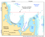
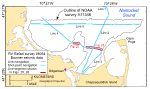
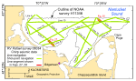
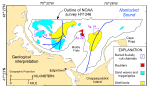
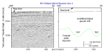
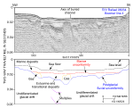
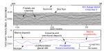
The seismic profiles acquired during the 2008 RV Rafael cruise 08034 (figs. 12, 13) provide insights into the stratigraphic framework and Quaternary geologic history of the sea floor off Edgartown, Massachusetts. Four sedimentary units are inferred from the subbottom profiles: coastal-plain deposits, glacial drift, estuarine and transitional deposits, and marine deposits. The deepest seismic reflectors observed beneath the study area are interpreted to be coastal-plain deposits of Late Cretaceous to Tertiary age. These reflectors are most conspicuous beneath the elongate bathymetric high that extends seaward from Middle Flats (fig. 25). On the basis of earlier interpretations of seismic data (O'Hara and Oldale, 1987), cuttings recovered from an onshore borehole (Hall and others, 1980), and outcrops on western Martha's Vineyard (Skehan, 2001), these deposits are inferred to consist predominantly of unconsolidated to semi-consolidated sand and silty clay. Although not resolved by our shallow high-resolution seismics, these deposits overlie a bedrock surface reported to be composed of metamorphosed rocks of the Avalon or Meguma terranes (Oldale, 1969; Hallett and others, 2004). Unconformably overlying the coastal-plain strata are glacial-drift deposits of Pleistocene age (figs. 25, 26, 27, 28). Although the seismic profiles collected as part of this study did not permit regional differentiation of these deposits, stratigraphic position and seismic character suggest local deposits of subglacial till, outwash, and glaciolacustrine sediments. The till is characterized by hard reflectors that mimic the underlying unconformity. The outwash deposits are characterized by flat-lying and gently dipping reflectors put down under fluvial and deltaic environments. The glaciolacustrine deposits are characterized by finely laminated rhythmic reflectors, which we interpret to be varved, muddy sediments put down in proglacial lakes. Overlying the undifferentiated glacial drift is a fluvially cut unconformity created by streams flowing generally toward the northeast. Channels created by these streams, which are now partly to mostly filled by estuarine and transitional deposits, are best developed beneath Edgartown Harbor and offshore of Edgartown Beach, where they coalesce into a dendritic pattern (figs. 21, 26, 27). The seismic signal in the channel beneath Edgartown Harbor is locally attenuated by the presence of gas (figs. 26, 28). This gas is probably biogenic methane and suggests that the estuarine and transitional deposits there contain organic-rich sediments. Although small and patchy nearshore, areas covered by the gassy sediments expand offshore, obscuring much of the underlying stratigraphy within this channel. A marine unconformity cut during the last transgression separates the estuarine and transitional deposits from the overlying modern marine deposits. These marine sediments are thickest within the fluvially cut channels and other more protected areas and thin or absent in more exposed areas, such as on the elongate bathymetric high that extends seaward from Middle Flats (fig. 2). The seismic profiles collected during RV Rafael cruise 08034 (figs. 12, 13) can be accessed through the tabular data listing below. To view the seismic-reflection profiles through the data listing, click on the line number in the first column to display a down-sampled Graphics Interchange Format (GIF) image of that seismic line. The image will be displayed in a new browser window. All preview images have been reduced to 72 dpi and a maximum width of 650 pixels for optimum viewing with a web browser. Because the original sizes of the preview images varied, please note that the images are not the same scale. To access a full-resolution image of the seismic profile in either Joint Photographic Experts Group (JPEG) or SEG-Y format, the user is advised to download the desired image, exit their browser, and open the file in an appropriate application (such as Corel Draw or Adobe Illustrator for a JPEG file). Instructions for downloading the full-resolution images follow the data listing.
Downloading with Internet Explorer, Firefox, or Safari To download a data file while using Internet Explorer, Firefox, or Safari, the user should select the desired file by placing the system pointer on the file name from the data list and pressing the right mouse button. This will display a pulldown menu from which the user should drag the mouse to highlight "Save Target As ..." and release the mouse button. Explorer will then prompt the user to specify the name and location of where the selected data file should be saved. |
|

![]() U.S. Department of the Interior |
U.S. Geological Survey
U.S. Department of the Interior |
U.S. Geological Survey
URL: https://pubsdata.usgs.gov/pubs/of/2009/1001/html/seismics.html
Page Contact Information: Contact USGS
Page Last Modified: Wednesday, 07-Dec-2016 22:23:37 EST