U.S. Geological Survey Open-File Report 2009-1001
Geological Interpretation of the Sea Floor Offshore of Edgartown, Massachusetts
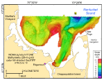
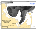
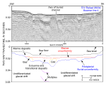
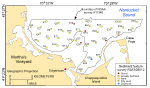
The data and interpretations in this report are based on NOAA survey H11346 completed during 2004 and two USGS verification cruises completed during 2008. These combined data provide a fundamental framework for research and management activities along this part of the Massachusetts coastline, show the composition and terrain of the seabed, and provide information on sediment transport and benthic habitat. Surveyed depths within the study area range from less than 4 m to almost 20 m (fig. 19). The shallowest areas are along the shorelines and on the elongate bathymetric high that extends northeastward from Middle Flats toward the central part of the study area. This elongate bathymetric high is flanked by depressions. To the southeast, an elongate depression connects Edgartown Harbor with the deepest part of the study area north-northwest of Cape Poge. Most gradients are relatively gentle except in constricted areas, such as between the elongate bathymetric high in the center of the study area and Cape Poge. There, tidal currents maintain steeper slopes. Distinctive tonal patterns revealed on the sidescan-sonar mosaic can be related to seabed features (fig. 20). Complex patches of high and low backscatter with individual high-backscatter targets delineate the rocky, bouldery areas. Bouldery areas on the mosaic are limited to the tip of the seaward extension of Middle Flats. Areas characterized by alternating bands of high and low backscatter include much of the western part of the study area between Oak Bluffs and Middle Flats and small patches off Cape Poge and the seaward extension of Middle Flats. This tiger-stripe pattern is produced by bedforms like sand waves and megaripples. Areas characterized by relatively high backscatter are concentrated along shorelines, on the crests and flanks of bathymetric highs, and in depressions east and west of the seaward extension of Middle Flats. Most of the areas of high backscatter are produced by coarse-grained sediments, typically coarse sand and gravelly sand; however, the areas of high backscatter east and west of the seaward extension of Middle Flats are caused by shell beds that produce strong acoustic backscatter. Patches characterized by relatively low backscatter are in the inner part of Edgartown Harbor and offshore in the deeper parts of the study area. These areas coincide with areas protected from strong storm- and tide-driven currents. The low backscatter is produced by fine-grained Holocene marine sediment. These sediments are clayey silt in the inner harbor and fine sand in deeper water. The seismic profiles provide insights into the stratigraphic framework and Quaternary geologic history of the sea floor off Edgartown, Massachusetts (fig. 26). The deepest seismic reflectors observed beneath the study area are interpreted to be coastal-plain deposits of Late Cretaceous to Tertiary age. Unconformably overlying the coastal-plain strata are Pleistocene glacial deposits of subglacial till, outwash, and glaciolacustrine sediments. Overlying the undifferentiated glacial drift is a fluvially cut unconformity created by streams flowing generally toward the northeast. Channels created by these streams, which are now partly to mostly filled by estuarine and transitional deposits, are best developed beneath Edgartown Harbor and offshore of Edgartown Beach, where they coalesce into a dendritic pattern. A marine unconformity cut during the last transgression separates the estuarine and transitional deposits from the overlying modern marine deposits. These marine sediments are thickest within the fluvially cut channels and other more protected areas and thin or absent in more exposed areas, such as on the elongate bathymetric high that extends seaward from Middle Flats. The surficial-sediment distribution is a product of the Quaternary history and modern environmental conditions (fig. 29). Gravel and gravelly sand are in the high-energy areas along exposed shorelines, such as off Cape Poge, and at the tip of the elongated bathymetric high that extends northeastward from Middle Flats. Sand is the dominant textural class of the sediment along the more protected shorelines, such as off Edgartown Beach, along the flanks of the elongated bathymetric high that extends northeastward from middle flats, and in the offshore parts of the study area in Nantucket Sound. Finer grained sediments are limited to deeper, more protected areas. Patches of silty sand are both east and west of the elongated bathymetric high that extends northeastward from Middle Flats. The finest grained sediment is clayey silt, which dominates in Edgartown Harbor where low-energy conditions characterized by sedimentary processes associated with deposition prevail. |

![]() U.S. Department of the Interior |
U.S. Geological Survey
U.S. Department of the Interior |
U.S. Geological Survey
URL: https://pubsdata.usgs.gov/pubs/of/2009/1001/html/summary.html
Page Contact Information: Contact USGS
Page Last Modified: Wednesday, 07-Dec-2016 22:23:42 EST