U.S. Geological Survey Open-File Report 2009-1001
Geological Interpretation of the Sea Floor Offshore of Edgartown, Massachusetts
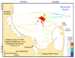
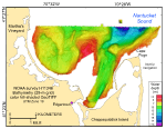
The original bathymetric dataset produced during NOAA survey H11346 is composed largely of single-beam echosounder data supplemented by smaller areas of multibeam coverage (fig. 18). Imagery produced from this reconnaissance dataset included large areas of no data because single-beam echosounders only record depth directly beneath the ship's track. Therefore, these data were regridded to 25 m to provide a more continuous perspective of the topography and benthic character of the sea floor (fig. 19). This perspective can be displayed as grids and images that facilitate interpretation of features and processes of smaller scale than those in the original dataset. Surveyed depths within the study area range from less than 4 m to almost 20 m. The shallowest areas are along the shorelines and on the elongate bathymetric high that extends northeastward from Middle Flats toward the central part of the study area. This elongate bathymetric high is flanked by depressions. To the southeast, an elongate depression connects Edgartown Harbor with the deepest part of the study area north-northwest of Cape Poge. Depths in Edgartown Harbor average approximately 10.5 m. To the northwest of the elongate bathymetric high, several shallower (8.5–9.5 m) depressions are connected by a faint dentritic or branching pattern. The morphology of both systems suggests that they are the products of drainage patterns that predate the Holocene marine transgression. Most gradients are relatively gentle except in constricted areas, such as between the elongate bathymetric high in the center of the study area and Cape Poge. There, tidal currents maintain steeper slopes. |

![]() U.S. Department of the Interior |
U.S. Geological Survey
U.S. Department of the Interior |
U.S. Geological Survey
URL: https://pubsdata.usgs.gov/pubs/of/2009/1001/html/bathy.html
Page Contact Information: Contact USGS
Page Last Modified: Wednesday, 07-Dec-2016 22:22:55 EST