U.S. Geological Survey Open-File Report 2011-1113
Summary of Oceanographic and Water-Quality Measurements in West Falmouth Harbor and Buzzards Bay, Massachusetts, 2009-2010
| Click on figures for larger images |
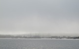 |
| Figure 1.Photograph of West Falmouth Harbor, looking east from the harbor entrance near Buzzards Bay |
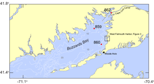 |
| Figure 2. Map of portions of southeastern Massachusetts, Cape Cod, and Buzzards Bay. Moorings in Buzzards Bay and Cape Cod Canal are indicated with a red circle and mooring number (859, 860, and 862). Bathymetric contours are in meters, referenced to mean low water. Box indicates inset for figure 3. |
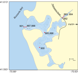 |
| Figure 3. Map of West Falmouth Harbor, Massachusetts. Moorings in West Falmouth Harbor are indicated with a red circle and mooring number (882, 883, 884, 885, 886, 887, 888, 900, and 901). Bathymetric contours are in meters. FWTP, Falmouth Wastewater Treatment Plant. |
|
This data report presents oceanographic and water-quality observations made at several locations in West Falmouth Harbor and Buzzards Bay, Massachusetts (figs 1,2, 3), from August 2009 to September 2010. Both Buzzards Bay and West Falmouth Harbor are estuarine embayments; the input of freshwater to the eastern margin of Buzzards Bay adjacent to Cape Cod and to West Falmouth Harbor is largely due to groundwater (LeBlanc and others, 1986). In West Falmouth Harbor, the groundwater that seeps into the harbor is characterized by relatively high levels of nitrate (Kroeger and others, 2006; Howes and others, 2006), supplied by the Falmouth Wastewater Treatment Plant (FWTP). This high nitrate load has modified the ecology of the harbor and may be a significant source of nitrate to Buzzards Bay during seasons with low biological nitrate uptake (Howes and others, 2006). The U.S. Geological Survey (USGS) undertook these measurements to improve understanding of circulation, residence time, and water quality in the harbor and bay.
Background
The FWTP is situated on a topographic high east of West Falmouth Harbor; the harbor is at sea level (fig. 3). Groundwater from the Cape Cod Aquifer flows down this gradient, and this freshwater enters the harbor where the surface aquifer intercepts the shoreline and harbor bottom (LeBlanc and others, 1986; Kroeger and others, 2006). In the past, the FWTP used a surface spraying method to treat sewage, leading to high levels of nutrients in the underlying groundwater (Howes and others, 2006). Those nutrients, including nitrate (NO3), made their way into the harbor, altering the ecological cycle in terms of productivity, dissolved oxygen, and benthic community structure (Howes and others, 2006). In recent years, the FWTP has improved sewage treatment, and the loads of nitrate are expected to decrease (Howes and others, 2006). The studies conducted in 2009 and 2010 aimed to ( 1) quantify the spatial and temporal variability of water quality in the harbor; (2) estimate fluxes of water, salt, and nitrate at specific cross-sections;and (3) provide data for confirmation of hydrodynamic and biogeochemical models. Between
June and August 2009, continuous measurements were collected in Buzzards Bay
(moorings 859, 860, 862; fig. 2) and at
the mouth of West Falmouth Harbor (mooring 901; fig. 3).
Between July and September 2010, continuous measurements were collected at four
sites within West Falmouth Harbor (moorings 882, 883, 884, 885, 886,
887, 888, and 900; fig. 3). All measurements were
made during summer months. Parameters measured include water level, velocity,
salinity, temperature, pH, dissolved oxygen, chlorophyll-a, and nitrate
concentration.
|


