U.S. Geological Survey Open-File Report 2011-1113
Summary of Oceanographic and Water-Quality Measurements in West Falmouth Harbor and Buzzards Bay, Massachusetts, 2009-2010
| Click on figures for larger images |
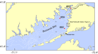 |
| Figure 2. Map of portions of southeastern Massachusetts, Cape Cod, and Buzzards Bay. Moorings in Buzzards Bay and Cape Cod Canal are indicated with a red circle and mooring number (859, 860, and 862). Bathymetric contours are in meters. |
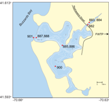 |
| Figure 3. Map of West Falmouth Harbor, Massachusetts. Moorings in West Falmouth Harbor are indicated with a red circle and mooring number (882, 883, 884, 885, 886, 887, 888, 900, and 901). Bathymetric contours are in meters. FWTP, Falmouth Wastewater Treatment Plant. |
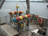 |
| Figure 4. Tripods prior to deployment in Buzzards Bay (moorings 859, 860). |
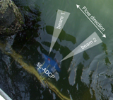 |
| Figure 6. Position and schematic of beam spread for the SL-ADCP deployed on pier, facing entrance channel to West Falmouth Harbor (mooring 901). Actual beams traveled over 20 m into the channel before interference with the channel bed and water surface (due to beam vertical spreading). |
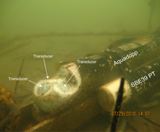 |
| Figure 7. Upward-looking Nortek Aquadopp and Sea-Bird 39 PT sensor deployed on the seabed (moorings 882, 885, 887). White paste on transducers is zinc oxide, used to reduce biological growth that interferes with signal transmission. |
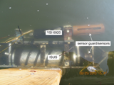 |
| Figure 8. Satlantic ISUS nitrate sensor and YSI 6920 multiparameter sonde deployed on floating dock at 0.12 meters below surface (mooring 883). |
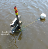 |
| Figure 9. Sea-Bird MicroCATs deployed on a vertical tower array (mooring 884). Three sensors were mounted on this array at 0.33 meters above bottom (not visible), 0.55 meters above bottom, and 0.77 meters above bottom. |
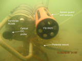 |
| Figure 10. Aanderaa RCM9 with optical dissolved oxygen (DO) probe and YSI 6920 multiparameter sonde, deployed on the seabed using a pedestal mount (mooring 886) 0.3 meters above bottom. Mooring 888 used a similar mount, with only a YSI multiparameter sonde. |
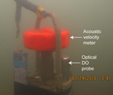 |
| Figure 11. Aanderaa RCM9 with acoustic velocity meter and optical dissolved oxygen (DO) probe mounted on seabed (mooring 900). |
2009
Mooring 859: Buzzards Bay North This site is located on the northwest side of Buzzards Bay (fig. 2), in 9.6 m of water. A tripod was deployed on the bed, with two upward-looking ADCPs, a pressure-temperature sensor, a conductivity-temperature sensor, and a transmissometer (fig. 4). Mooring 860: Buzzards Bay South
This site is located on the eastern edge of Buzzards Bay
(fig. 2), in 15.3 m of water. A tripod was deployed on the bed,
with two upward-looking ADCPs, a pressure-temperature sensor, and a conductivity-temperature sensor (fig.
4).
Moorings 861 and 862: Cape Cod Canal at Massachusetts Maritime Academy This site
is located at the southwest entrance to the Cape Cod Canal, at the
Massachusetts Maritime Academy
(fig. 2).
A side-looking ADCP was deployed on the
rudder of the T/S Kennedy
at 4 m below the surface (861),
and a
pressure-temperature and conductivity-temperature sensor were deployed on the bed adjacent to the
ship (862).
Mooring 901: Mouth of West Falmouth Harbor This
site is located on the dock on the south side of the West Falmouth Harbor
entrance (fig. 3). A side-looking ADCP was mounted between dock pilings, with a
multiparameter sonde deployed adjacent to the ADCP (fig. 6).
2010
Moorings 882, 883, and 884: Mashapaquit Creek This site is located at the northeast corner of the harbor, where the tidal Mashapaquit Creek meets the harbor (fig.3). An I-frame mounted upward-looking ADCP along with PT sensor was deployed in 1 m of water (882), landward of the Nashawena Street bridge. A multiparameter sonde and nitrate sensor were mounted on a floating dock 100 m landward of the bridge (883; fig. 8), on the north side of the creek, approximately 0.1 m below the water surface. A vertical pole with three CT sensors was deployed 2 m from the dock, with sensors spaced at 0.33, 0.55 and 0.77 mab (fig. 9). Moorings 885 and 886: Inner-Middle Harbor JunctionThis
site is located adjacent to the navigation channel that connects the
middle harbor to the outer harbor of West Falmouth Harbor, in 3 m of
water (fig. 3). This site consisted of an I-frame mounted upward-looking ADCP
and PT sensor (885; fig. 7), and a bed-mounted multiparameter sonde on a pedestal
mount (886; fig. 10). Also attached to the pedestal mount was an optical dissolved
oxygen probe.
Moorings 887 and 888: Mouth of West Falmouth Harbor
This site is located adjacent to the harbor entrance channel in 3 m
of water (fig. 3). This site consisted of a bed-mounted upward-looking ADCP with a
PT sensor on an I-frame (887), and a bed-mounted multiparameter sonde on
a pedestal mount (888).
Mooring
900: South Cove of West Falmouth Harbor
This site is located in the south cove of the harbor, in 1 m of water (fig. 3). This site consisted of a board-mounted optical dissolved oxygen probe and fig. 11).
|


