| |  |  | | Lake Pontchartrain Atlas: | | | | | | | | | | | | | | | | | | | | | | | | | | | | | | | Environmental Issues |  | | | | | | | | | | | | | |  | | | | | | | | | | |  | Environmental Issues - Water Quality Contributors: McCorquodale, Georgiou, Haralampides A contour map of the bottom dissolved oxygen during a survey period on July 23 and 29, 1998 is shown in Figure 68. The image combines field data from two surveys, a Lakewide survey and a local survey near the IHNC. The persistent high temperatures during the summer, along with the high vertical salinity gradients originating from the IHNC (Figure 69), produce extremely low oxygen conditions in the bottom waters of Lake Pontchartrain. The dynamics of this low oxygen plume as a result of salt water intrusion from the IHNC are rather complex. However, the field data suggest that this plume is highly affected by circulation patterns in the Lake. There appears to be a strong correlation with numerical modeling results obtained by Haralampides et al.,(2000) and Signell and List (1995). The circulation pattern produced by similar southeasterly winds in Lake Pontchartrain by Haralampides et al., (2000) matches the deformation of the salt water and dissolved oxygen plumes, respectively, shown in Figure 68 and 69. 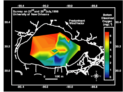 | | Figure 68: Contour map of bottom dissolved oxygen for Lake Pontchartrain. | 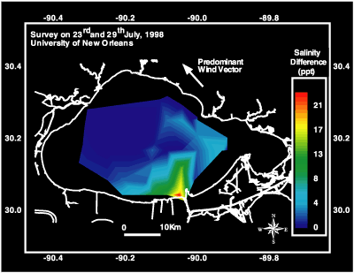 | | Figure 69: Contour map of salinity for Lake Pontchartrain. | « Previous | Next » |
