Environmental Issues - Water Quality Contributors: Carnelos, McCorquodale, Barbé 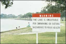 | | Figure 70: South Shore of Lake Pontchartrain. (Courtesy of the U.S. Army Corps of Engineers, NOD) | Background In 1962, the LDHH issued an advisory discouraging swimming and other primary contact recreation in Lake Pontchartrain. Today, the advisory remains in effect for the south shore area of the lake in Orleans Parish where signs are posted that warn the water is unsuitable for swimming or bathing and may be hazardous to the user's health (Figure 70). The LDEQ names fecal coliform bacteria as the causative pollutant. Nature of Urban Stormwater Runoff Discharges Most of the stormwater runoff is pumped to the Lake since the average elevation in New Orleans is several feet below sea-level and flood protection levees have been constructed to protect the city from Mississippi River floodwater and hurricane induced tidal surges in Lake Pontchartrain. An extensive drainage network consisting of subsurface and open surface canals exists to collect the runoff, which is then discharged to the Lake via a system of pump stations and open surface drainage canals. The primary suspected source of the bacteria in the nearshore waters of the south shore area of Lake Pontchartrain is urban stormwater runoff from the New Orleans metropolitan area that is discharged to the Lake at various points along the shoreline. It is believed that the effluent is contaminated by sanitary sewer cross-flows. The runoff has a freshwater density and the Lake is typically a brackish water body of greater density. Thus, the effluent usually behaves as a surface-buoyant plume, and the resulting buoyancy flux causes greater spreading and modifies the dilution. Many of the outfalls along the south shore of the Lake have discharge velocities insufficient to foster the momentum required to move the effluent away from the nearshore region and to provide adequate momentum mixing. In addition, the presence of ambient longshore currents often produces narrow outfall plumes that travel along the shoreline resulting in inhibited spreading and dilution. The aerial photographs of stormwater runoff discharges to Lake Pontchartrain in Jefferson Parish are representative of plume behavior observed in the south shore of the Lake (Figure 71).  | | 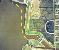 | | Figure 71: Aerial photographs showing typical outfall plume behavior. (Courtesy of Jefferson Parish.) The dashed yellow lines indicate the edge of the plume. | Preliminary 3-D hydrodynamic model output for a plume migration simulation of a surface-buoyant discharge from an urban outfall canal agrees well with the plume behavior observed on the south shore (Figure 72). 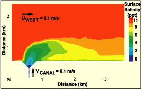 | | Figure 72: Preliminary hydrodynamic model output for plume behavior resulting from simulated canal discharge. | Actual urban outfall migration data have been obtained through a plume-tracking program begun recently at the UNO in cooperation with Tulane University, the LPBF and the Sewerage and Water Board of New Orleans (S&WB). In this study an Argos free-drifting buoy is deployed at the mouth of a drainage canal upon notification of a pump event by pump station operators. The drifter is carried by the stormwater runoff plume and the path coordinates are transmitted at regular intervals so that the plume migration can be tracked. 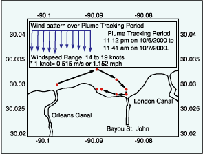 | | Figure 73: Tracking path of plume from pump station discharge originating from New Orleans canal on October 6, 2000. | 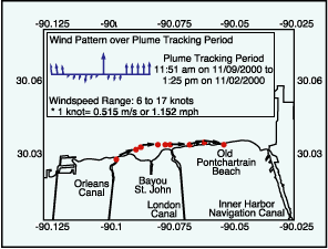 | | Figure 74: Tracking path of plume from pump station discharge originating from New Orleans canal on November 9, 2000. | The paths of urban runoff plumes resulting from pump station discharges from Orleans Canal on October 6, 2000 and November 9, 2000 were tracked for approximately 12.5 hours and 13.5 hours, respectively. The plume trajectories for these stormwater discharges are shown in Figures 73 and 74. The range of wind speed and direction over these periods were obtained from the National Climatic Data Center (NCDC) and are also shown in Figures 73 and 74. Evident from these plots is the significant impact that these discharges may have on the nearshore waters of adjacent recreational areas. « Previous | Next » | 