| |  |  | | Lake Pontchartrain Atlas: | | | | | | | | | | | | | | | | | | | | | | | | | | | | | | | Environmental Issues |  | | | | | | | | | | | | | |  | | | | | | | | | | |  | Environmental Issues - Water Quality Contributors: Abadie, Poirrier High salinity bottom water has entered Lake Pontchartrain through the IHNC since the MRGO was completed in 1963. This saltwater intrusion produces salinity stratification and episodic bottom water hypoxia (dissolved oxygen < 2 ppm). Although hypoxia can occur under natural conditions, it has become more widespread in estuaries due to eutrophication and hydrological modifications. Short periods of hypoxia can have long-term effects on benthic communities and ecological processes. Benthic invertebrates live in the bottom sediments and are regarded as excellent indicators of adverse water quality because of their sessile nature. Episodic hypoxia is often difficult to detect by direct measurement because it may be limited to a relatively thin layer of water above the sediment and occur during a rare combination of environmental conditions. However, changes in benthic community structure, such as decreased species diversity and an increased proportion of tolerant species, may indicate hypoxic events. 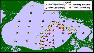 | | Figure 88: Map of Lake Pontchartrain. Triangles indicate sites surveyed in 1997 and circles indicate sites surveyed in 1999. Red symbols represent sites where the clam density was significantly lower than yellow. | The occurrence of hypoxia has been documented in previous studies. Poirrier (1978) reported salinity stratification from the intrusion of more saline bottom water near the mouth of the IHNC. Lower bottom dissolved oxygen concentrations, associated with stratification and episodic hypoxia, occurred during the summer. Junot (1979) and Junot et al., (1983) demonstrated an adverse effect on benthic biota and low Shannon Weaver diversity that was attributed mainly to low bottom dissolved oxygen caused by salinity stratification. Sikora and Sikora (1982) attributed this "dead zone" to an event of acute chemical toxicity. However, later studies also demonstrated that summer hypoxic conditions can extend from the IHNC to the middle of the lake, and that low dissolved oxygen associated with salinity stratification rather than toxic pollutants was the cause of the stressed benthic invertebrate community (Poirrier et al., 1984, Schurtz and St. Pe`, 1984). Deposits of Rangia cuneata shells were dredged from the lake bottom from 1933 to 1990. A recent survey of Lake Pontchartrain benthic invertebrates indicates that the density of large (>20 mm) (>0.79 in) Rangia cuneata clams, which was reduced by shell dredging, has recovered to 1950's levels since shell dredging was stopped (Abadie and Poirrier 2000). However, large clams were still absent from a large area in the lake north of the IHNC associated with salinity stratification and episodic hypoxia. This effect of hypoxia on the clam population was not evident prior to the recovery of large clams from shell dredging throughout the rest of the lake. Triangles on the map in Figure 88 represent sites from this study. Red triangles identify sites where the large clam density is significantly lower than the densities at representative sites in the lake not associated with the hypoxic zone. Yellow triangles show sites where the clam densities were not significantly different from the representative sites. A survey was conducted around the perimeter of the red triangles during the spring and summer of 1999 to better define the hypoxic area based on the distribution of large clams. Circles on the map show the location of the sites from this survey (Figure 88). Red circles indicate sites with very low clam densities, significantly lower than the rest of the lake. In most cases, no clams were found at these sites. The yellow circles show where clam densities were comparable to sites outside of the hypoxic zone. We have estimated that a 250 km2 area (97 mi2) is affected by saltwater intrusion and episodic hypoxia based on large clam densities. In a water quality study by Schurtz and St. Pe` (1984) this same area was shown to be affected by saltwater intrusion and episodic summer hypoxia. The absence of large clams from this extensive area indicates that episodic hypoxia is a serious environmental problem. Using densities of large clams may be a better indicator of environmental stress than dissolved oxygen measurements, Shannon Weaver diversity indices or other traditional community analysis for several reasons. Rangia clams that are > 20 mm (> 0.79 in) are 2 to 3 years old. Since they are long-lived, they are good detectors of episodic hypoxia. Smaller sized Rangia are found in the hypoxic zone but they die before they reach maturity. The typical opportunistic species that are common in the area of hypoxia are either tolerant of the hypoxic events or able to reestablish populations quickly. In addition, clams can be quickly sorted and counted in the field, as opposed to tediously sorting, identifying and counting whole benthic collections, which is required for computing diversity values. Benthic invertebrates and surface and bottom dissolved oxygen have also been sampled at sites along a transect extending north from the IHNC on a seasonal basis since 1997. Hypoxia has been documented along the transect during the summer. Other evidence of hypoxia includes low species diversity and a predominance of annelids, but the best indicator of hypoxia is the absence of older, larger clams. This was not evident prior to the cessation of shell dredging and the return of large clams because clams were absent throughout the entire Lake. When compared to other monitoring methods, the distribution of large Rangia clams is an easy and accurate indicator of the distribution of hypoxia in Lake Pontchartrain. Closure of the MRGO or the placement of a sill near the mouth of the IHNC would reduce the movement of high salinity water, which causes hypoxia, and would restore 250 km2 (97 mi2) of shellfish habitat. Because clams are abundant and active filter feeders, restoration would increase south shore water clarity and reduce the concentration of fecal coliforms. In addition, essential fish habitat would increase due to grassbed growth from improved water clarity and the production of clam shells that produce hard bottom reefs. « Previous | Next » |
