| |  |  | | Lake Pontchartrain Atlas: | | | | | | | | | | | | | | | | | | | | | | | | | | | | | | | Environmental Issues |  | | | | | | | | | | | | | |  | | | | | | | | | | |  | Environmental Issues - Water Quality Contributors: Carnelos, McCorquodale, Barbé Background A south shore area of Lake Pontchartrain in Orleans Parish has been the focus of a water quality study initiated at UNO in September of 1998. This area is under a primary contact recreation advisory that was issued by the LDHH naming FC bacteria as the causative pollutant. Five monitoring stations along the south shore currently or previously used for primary contact recreation comprise the study area (Figure 79). LP#3 and LP#5 are found at the outlets of the London and Orleans Canals, respectively. LP#1 is a beach area and fishing boat launch near the IHNC. LP#2 is the site of the Old Pontchartrain Beach. LP#4 is the Old Beach recreational park area near Bayou St. John. 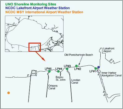 | | Figure 79: UNO water quality monitoring stations along the southern shore of Lake Pontchartrain. | More than two years of data have been collected to determine if the bacterial environment has improved sufficiently to be deemed safe for primary contact recreation since regular sampling by the LDHH was stopped ten years ago. The same risk assessment was performed for the secondary contact recreation season. Samples measured for FC are taken five times per month as required by the LDEQ, Louisiana Environmental Regulatory code, Title 33, Environmental Quality, Part IX: Water Quality Regulations, Chapter 11, 1999: Surface Water Quality Standards (LAC 33:IX.1111.C). "Primary contact recreation" is defined as "any recreational or other water use in which there is prolonged and intimate body contact with the water involving considerable risk of absorbing waterborne constituents through the skin or of ingesting constituents from water in quantities sufficient to pose a significant health hazard" (LDEQ, 1999). Swimming, water skiing and skin diving are cited as examples of primary contact recreation. "Secondary contact recreation" is defined as "any recreational or other water use in which body contact with the water is either incidental or accidental, and in which the probability of ingesting appreciable quantities of water is minimal" (LDEQ, 1999). Fishing, wading, commercial or recreational boating and any limited contact incident to shoreline activity are cited as examples of secondary contact recreation. Pathogen Indicators Indicator bacterial groups are measured to determine the potential presence of pathogens, i.e., bacteria and organisms that can cause communicable diseases, such as infections of the skin, eyes, ears, nose and throat. Coliform bacteria groups are often used as indicators because they are easily detectable, generally not found in unpolluted waters and the number of indicator bacteria tends to be correlated to the extent of contamination. FC is an indicator group for organisms from the tract of humans and other animals and was used in the study because it was named in the LDHH advisory and is used by the LDEQ for regulatory purposes when dealing with recreational use of surface waters. Recreational Use Risk Assessment The primary contact recreation season extends from May 1 through October 31 and the secondary contact recreation season lasts from November 1 to April 30. More stringent standards for FC levels are applied to the primary contact season. The probability, or risk, of encountering FC concentrations greater than 200 MPN/100 mL and 1,000 MPN/100 mL during the primary and secondary contact recreation seasons, respectively, at each study site is shown in Figures 80 and 81. In general, "wet weather" conditions resulted in a greater risk of encountering unsafe FC levels throughout the study area. However, the risk associated with elevated FC levels is greater under "dry weather" conditions during the secondary contact recreation season at station LP#1. This is probably due to the presence of a separate, unknown source, independent of stormwater runoff, at this site. The percent non-compliance with the LDEQ criteria given for safe use of recreational waters observed during the primary and secondary contact recreation seasons is also shown in Table 21. 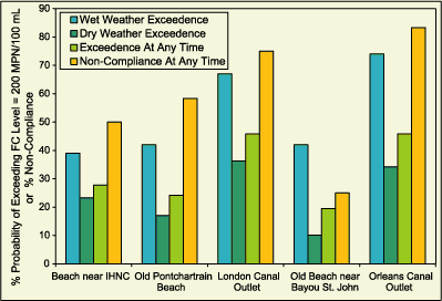 | | Figure 80: Probability of exceeding FC concentrations of 200 MPN/100ml during recreation seasons for southern Lake Pontchartrain. | 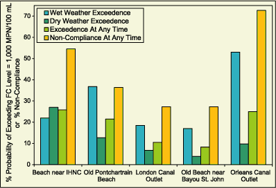 | | Figure 81: Probability of exceeding FC concentrations of 1,000 MPN/100ml during recreation seasons for southern Lake Pontchartrain. |  | 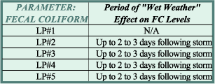 | | Table 21: Percent non-compliance with LDEQ regulations regarding concentration of FC in recreational waters. | Table 22: Period of time after "wet weather" conditions (storm event) that elevated levels of FC were found in recreational waters. | | The overall percent non-compliance over the study period, irrespective of season or climatic conditions, ranged from as low as 26% at station LP#4 to as high as 78% at station LP#5 while non-compliance was observed about half of the time at the remaining sites. | Elevated FC levels were found to be correlated to "wet weather" conditions, ie. climatic conditions characterized by rainfall events sufficient to initiate pumping of stormwater runoff discharges to the Lake, throughout most of the study area. An investigation of predictive relationships between FC and precipitation showed that the "wet weather" effect appears to last for two to three days after a significant rainfall event (greater than 1.3 cm (0.5 in) at stations LP#2, LP#3, LP#4 and LP#5 (Table 22). Thus, it might be suggested that a general rule of thumb for recreational use of these south shore areas of Lake Pontchartrain is that the user should assume that the water is unsuitable for primary contact recreation, especially in the near vicinity of urban drainage canals, for at least two to three days following a storm event. This advice cannot be extended to the area near station LP#1, however, since the occurrence of FC observed in this area suggests that there may be an active continuous bacteria source near this site, i.e., in the IHNC. Consideration of Climatic Effect on Risk Evaluation The data collected for this risk evaluation were collected during a period distinguished by a significant reduction in typical annual rainfall amounting to about 30% of the normal annual precipitation. Under normal (non-drought) conditions a higher incidence of unsafe bacteria levels is expected. « Previous | Next » |
