| |  |  | | Lake Pontchartrain Atlas: | | | | | | | | | | | | | | | | | | | | | | | | | | | | | | | Environmental Issues |  | | | | | | | | | | | | | |  | | | | | | | | | | |  | Environmental Issues - Water Quality Contributors: Carnelos, McCorquodale, Barbé Water Quality Study A south shore area of Lake Pontchartrain in Orleans Parish has been the focus of a water quality study initiated at UNO in September of 1998 (Figure 75). Five monitoring stations along the south shore comprise the study area. LP#3 and LP#5 are found at the outlets of the London and Orleans Canals, respectively. LP#1 is a beach area and fishing boat launch near the IHNC. LP#2 is the site of the Old Pontchartrain Beach. LP#4 is the Old Beach recreational park area near Bayou St. John. 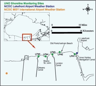 | | Figure 75. UNO water quality monitoring stations along the southern shore of Lake Pontchartrain. | The parameters measured were fecal coliform bacteria (FC), salinity, conductivity, water temperature, nitrogen as ammonia, total nitrogen as nitrite/nitrate, total Kjeldahl nitrogen (TKN), total phosphorus (P), ortho-phosphates, total and volatile suspended solids (TSS and VSS) and pH. Daily rainfall data and average daily wind speeds measured at a NCDC monitoring station located in the sampling area are also included in the database. Salinity Steadily increasing salinity levels were observed in the study area over the monitoring period (Figure 76). Typical salinity levels observed at the beginning of the study in September of 1998 were in the range of 6.0 to 6.5 ppt. Over a study period of slightly more than two years a steady increase in salinity to levels in the range of 12.5 to 13.5 ppt was observed. 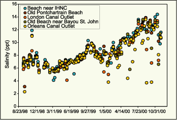 | | Figure 76. Salinity data (ppt) from each of the five UNO monitoring stations. | 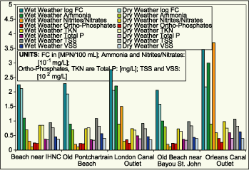 | | Figure 77. Comparison of nutrient and solid concentrations during "wet weather" and "dry weather" conditions. | Nutrients and Solids Evidence was found that urban stormwater discharges to this south shore area of the Lake are a source of pathogens (as indicated by FC) as well as nutrients and solids. Cross-contamination of the stormwater runoff effluents by sanitary sewer flows is a suspected source of the pathogens, nutrients and solids. Higher concentrations of nitrogen, phosphorus and suspended solids were observed to coincide with elevated FC levels resulting from urban stormwater discharges. The comparison of the average concentrations of FC, ammonia, total nitrogen as nitrites/nitrates, TKN, ortho-phosphates, total P, TSS and VSS under "wet weather" and "dry weather" conditions are shown in Figure 77. 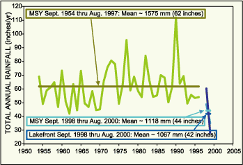 | | Figure 78. Annual precipitation data over a period of 46 years showing a large decrease in rainfall during the study period. | Precipitation Analysis The study period was characterized by an unusual precipitation pattern that may be described as a drought. Historical rainfall data from a NCDC weather station located at the New Orleans International Airport (MSY) were obtained for a period of approximately 43 years (Figure 78). NCDC rainfall data for the study period were collected at the MSY weather station as well as the Lakefront Airport weather station located in the study area. A comparison of the datasets showed that the study period is distinguished by a significant reduction in typical annual rainfall amounting to approximately 30% of the normal annual precipitation. This abnormal precipitation pattern is an important component in assessing the water quality in this area since urban stormwater runoff discharges to these waters have been identified as a source of pathogens, nutrients and solids. Under normal (non-drought) conditions, a higher incidence of elevated levels of pathogens, nutrients, such as nitrogen and phosphorus, and solids, especially organics indicated by VSS, is expected. « Previous | Next » |
