Environmental Issues - Water Quality Contributors: Carnelos, McCorquodale, Barbé Water Quality Study A south shore area of Lake Pontchartrain in Orleans Parish has been the focus of a water quality study at UNO since September of 1998. This area is under a primary contact recreation advisory that was issued in 1985 by the LDHH and names FC bacteria as the causative pollutant. The primary suspected source of the bacterial pollution is pumped urban stormwater runoff contaminated by sanitary sewer cross-flows that is discharged to the area (Figure 82). Five monitoring stations along the south shore currently or previously used for primary contact recreation comprise the study area. Two of the stations are located at the outlets of urban runoff drainage canals. LP#3 and LP#5 are found at the outlets of the London and Orleans Canals, respectively. The other stations are beach or recreational park areas located close to canals. LP#1 is a beach area and fishing boat launch near the IHNC. LP#2 is the site of the Old Pontchartrain Beach. LP#4 is the Old Beach recreational park area near Bayou St. John. More than two years of data have been collected and the effect of runoff events on bacterial counts has been observed. Samples measured for FC and other parameters are taken five times per month and in-situ measurements such as salinity are taken. Daily rainfall is measured at a NCDC monitoring station in the sampling area. 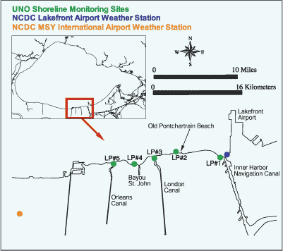 | | Figure 82: UNO water quality monitoring stations along the southern shore of Lake Pontchartrain. | Pathogen Indicators Coliform bacteria groups are often used as indicators because they are easily detectable, generally not found in unpolluted waters and the number of indicator bacteria tends to be correlated to the extent of contamination. FC is an indicator group for organisms from the intestinal tract of humans and other animals and was used in the study because it was named in the LDHH advisory and is used by the LDEQ for regulatory purposes when dealing with recreational use of surface waters. Urban Stormwater as a Source of Pathogens Probability of exceedence plots for FC under "wet weather" and "dry weather" conditions show that FC concentrations tend to be elevated under "wet weather" conditions, i.e., climatic conditions characterized by rainfall events sufficient to initiate stormwater runoff discharges. Figures 83 and 84 indicate the probability that a concentration can be expected to be exceeded at a given site under "wet weather" or "dry weather" conditions. 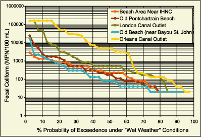 | | Figure 83: Probability of exceedence for FC under "wet weather" conditions. | 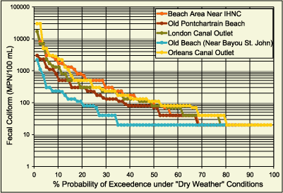 | | Figure 84: Probability of exceedence for FC under "dry weather" conditions. | The probability that FC levels are "wet weather" dependent was determined for each monitoring station (Table 23). A definite correlation was found to exist between rainfall events sufficient to initiate pumping of stormwater runoff and the occurrence of elevated bacteria levels at all sites except LP#1. This station was distinguished as the only area where FC concentrations were unrelated to storm events. The occurrence of FC observed at LP#1 suggests that there may be an active continuous bacteria source near this site, ie. in the IHNC. Furthermore, evidence was found to suggest that the bacterial environment at station LP#2 could be affected by adjacent sources to the east, ie. the IHNC and to the west, ie. London Canal, depending on lake circulation patterns. 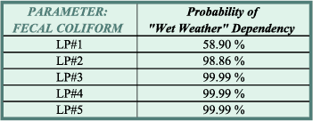 | | Table 23: Probability that increased levels of FC are dependent on "wet weather" conditions. | 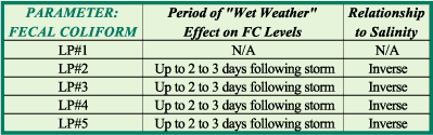 | | Table 24: Relationship of salinity levels to FC levels during "wet weather" conditions. | Analyses to determine any predictive relationships among FC and precipitation and salinity were performed for each location (Table 24). Rainfall quantities on the day of FC measurement and up to four days prior were considered to account for drainage basin lag times, stormwater discharge travel times and bacteria decay rates. Salinity was considered since Lake Pontchartrain is a brackish water body and decreased salinity is an indication of stormwater discharges of freshwater density. The "wet weather" effect appears to last for two to three days after a significant rainfall event greater than 1.3 cm (0.5 in) in the areas where FC has been directly linked to urban runoff discharges, ie. stations LP#2, LP#3, LP#4 and LP#5. Finally, an inverse relationship between the number of fecal coliforms and salinity was observed at all sites except LP#1. This observation supports the finding that the bacteria levels at site LP#1 are not "wet weather" dependent. « Previous | Next » | 