| |  |  | | Lake Pontchartrain Atlas: | | | | | | | | | | | | | | | | Environmental Status & Trends |  | | | | | | | | | | | | | | | | | | | | | | | | | | | | |  | | | | | | | | | | |  | Environmental Status and Trends - Status and Trends of the Lake Pontchartrain Basin Contributors: Penland, Maygarden, Beall 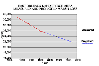 | | Figure 11: Measured marsh loss in the East Orleans Land bridge Area between 1932 and 1990 with projection to 2050 (Coast 2050, 1998). Refer to Table 5 for marsh loss comparison. | The East Orleans Land Bridge Area (EOLBA) lies in the eastern part of the Marginal Deltaic Basin geomorphic region (Figure 1) and encompasses the marshlands between the Chef Menteur and Rigolets Passes, as well as the marsh at South Point that lies outside of the hurricane protection levee (Figure 5). The EOLBA spans 45,638 acres of almost entirely brackish marsh within Orleans Parish. Throughout the marsh are many shallow ponds containing SAV. Some development follows the high ground along U.S. Highway 90. Most structures are fishing camps, with some more permanent dwellings. In 1949, the EOLBA was mapped as brackish and saline marsh with a small amount of intermediate marsh along U.S. Highway 90. By 1968, the entire area had become brackish and has remained so. Since 1932, approximately 5,470 acres of marsh have been lost in this area (Figure 11). The primary causes of land loss are shoreline erosion and direct removal. The hydrology of the EOLBA was altered by the construction of the GIWW and the Lake Pontchartrain Hurricane Protection Levee, which forms the eastern border of the area. Meanwhile, the subsidence rate is relatively low at less than 0.3 m (1.0 ft) per century. By 2050, a further 3,550 acres or 14 % of the 1990 is expected to be lost (Table 5). This low-lying land bridge protects Lake Pontchartrain from tropical storm surges and is, at the same time, vulnerable to inundation during storm events. Many shallow, open water areas and ponds filled with submersed aquatic vegetation (SAV) make this an important wintering area for waterfowl and a nursery area for estuarine fish. It is a popular recreational fishing area. The statistics from Coast 2050, shown in Tables 2, 3 and 4, show that most fish and bird populations have been steady over the past 10-20 years. However, these populations are predicted to decline in the near future. The exception is the brown pelican, which continues to increase in number, while alligators remain steady in number. « Previous | Next » |
