| |  |  | | Lake Pontchartrain Atlas: | | | | | | | | | | | | | | | | Environmental Status & Trends |  | | | | | | | | | | | | | | | | | | | | | | | | | | | | |  | | | | | | | | | | |  | Environmental Status and Trends - Status and Trends of the Lake Pontchartrain Basin Contributors: Penland, Maygarden, Beall The North Shore Marsh Area (NSMA) comprises 14,257 acres of intermediate and brackish marsh with a small amount of bottomland hardwood forest stretching along the northern shoreline of Lake Pontchartrain between Fontainebleau State Park and the Eden Isles development in St. Tammany Parish (Figure 5). The NSMA lies in the central part of the Marginal Deltaic Basin geomorphic region (Figure 1). The waterways draining this area include Bayous Castine, Cane, Lacombe and Liberty. The geomorphology of the Area is described in detail in the Geologic Setting of the Big Branch Shoreline section. 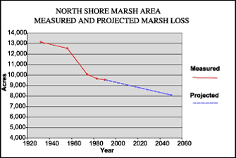 | | Figure 9: Measured marsh loss in the North Shore Marsh Area between 1932 and 2050 and projected to 2050 (Coast 2050, 1998). Refer to Table 5 for marsh loss comparison. | Figure 9 graphically displays the pattern of marsh loss in the NSMA since 1932. Between 1932 and 1990, some 3,600 acres of marsh were lost in this Area. The greatest rate of loss was between 1956 and 1974. In this time period, the MRGO was completed and Hurricane Betsy came ashore (1965). These two factors were responsible for saltwater intrusion which had a large impact on this Area. Between 1990 and 2050, approximately 1,470 more acres of marsh are likely to be lost in the NSMA due to altered hydrology and shoreline erosion (Table 5). These two factors will continue to account for much of the future loss. Subsidence, occurring at a rate of greater than 0.3 m (1.0 ft) per century, is also a factor in these loss rates, as is residential development. Despite management efforts to protect these marshes from residential development, some areas are still vulnerable due to the rapid population growth in St. Tammany Parish. This development pressure may lead to continued conversion of wetlands. The most important step taken in recent years to preserve these valuable marshes and associated habitats was the formation of the Big Branch National Wildlife Refuge in 1994. This refuge, comprising 15,000 acres, set aside a sizable portion of the last large undeveloped area along the north shore of the Lake. This expanse of shoreline is unique because it is the only area in coastal Louisiana with offshore grass beds, sandy beaches and marshes grading into hardwood and pine ridges along the northern margin of the area at the edge of the Pleistocene Terraces. Shallow open water areas within the marshes also contain lush beds of SAV. The entire NSMA is a particularly important habitat for migratory songbirds, waterfowl, wading and water birds as well as commercial and recreational fisheries. The population of wildlife and fisheries of the NSMA are generally steady. However, the numbers of brown pelicans, alligators and wading birds are increasing (Tables 2, 3 and 4). « Previous | Next » |
