| |  |  | | Lake Pontchartrain Atlas: | | | | | | | | | | | | | | | | Environmental Status & Trends |  | | | | | | | | | | | | | | | | | | | | | | | | | | | | |  | | | | | | | | | | |  | Environmental Status and Trends - Status and Trends of the Lake Pontchartrain Basin Contributors: Penland, Maygarden, Beall The South West Pontchartrain Area (SWPA) encompasses the swamps, forests and marshes of the Bonnet Carré Spillway and LaBranche Wetlands (Figure 1). This area is composed of 31,678 acres of swamp, bottomland hardwood forest, intermediate marsh, some fresh marsh, upland and open water. The Bonnet Carré Spillway, a relief channel for excess floodwater from the Mississippi River, was constructed in 1930, following the devastating flood of 1927 (Figure 5). The Spillway contains swamp and pockets of fresh marsh that have developed within borrow pits in the conveyance channel. The LaBranche Wetlands area to the east of the Spillway has suffered severe loss of marsh and swamp habitat during the Twentieth Century. Since the early 1900's, the forested acreage in this area has steadily declined due to development and conversion to marsh and open water. Early in the Twentieth Century a failed agricultural impoundment subsided and flooded, converting some of the intermediate marsh to open water. This was the first of the extensive open water areas now seen throughout the intermediate marsh. This pond was converted back to marsh in 1994 by the CWPPRA LaBranche Marsh Creation Project. In the 1960's, access canals dredged to construct U.S. Interstate 10 accounted for additional land loss and opened the shoreline to the intrusion of Lake Pontchartrain water. In the early 1960's, the MRGO was completed, providing a conduit for saltier water, especially in storm conditions. In 1965, Hurricane Betsy introduced a significant storm surge to Lake Pontchartrain, allowing more saline water to penetrate far into the wetlands surrounding Lake Pontchartrain. 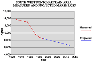 | | Figure 8 Measured marsh loss of Southwest Pontchartrain Area between 1932 and 1990 with projection to 2050 (Coast 2050, 1998). Refer to Table 5 for marsh loss comparison. | Historically, this area frequently received overflow from the Mississippi River which introduced sediment and fresh water to the wetlands. Today, the wetlands are generally isolated from the River unless the Spillway is opened or if significant leakage takes place. All of these factors, combined with a subsidence rate of between 0.3 and 0.6 m (1.0 and 2.0 ft) per century, have had a devastating effect on these wetlands. Intermediate marsh rapidly converted to open water ponds in the LaBranche Wetlands between 1956 and 1978, a time period in which Hurricane Betsy, the opening of the MRGO and the construction of U.S. Interstate 10 all took place (Figure 8). Figure 8 graphically illustrates marsh loss in the SWPA. Between 1932 and 1990, the SWPA lost 4,990 acres of marsh (Table 5). In addition to interior loss, shoreline erosion has claimed many acres. Shoreline erosion and elevated salinities are expected to continue, and a projected 7,080 acres of marsh and swamp are likely to be lost between 1932 and 2050 without restoration. Upon the completion of the St. Charles Hurricane Protection Levee, urban development is expected to affect forested wetlands along U.S. Highway 61 and near the New Orleans International Airport. This area has been significantly affected by industrial development, including oil and gas extraction, transport and refining. Bordering the LaBranche Wetlands, several oil refineries are situated close to the Mississippi River. As a result of historic disposal of refinery wastes to nearby waterways, there is a problem in the LaBranche Wetlands with contaminated sediment. Bayou Trepagnier, a state Scenic Stream just north of Norco, is a well-known example. The SWPA is vitally important habitat for wading birds, waterfowl and many other bird species. There were two active bald eagle nests documented within the LaBranche Wetlands during the 1996 to 1997 breeding season. This area is also a very important nursery for fish and crustacean species such as menhaden, blue crab and brown shrimp. The LaBranche Wetlands remain as the last productive fisheries nursery on the south shore of Lake Pontchartrain. The status and trends of some of the fish and wildlife populations in the SWPA may be found in Tables 2, 3 and 4. Generally, the SWPA has stable fish populations, although white and brown shrimp are projected to decline through 2050. The species that have been receiving federal protection in recent years under the Endangered Species Act, such as the bald eagle, brown pelican and alligator, are all experiencing increasing numbers and are likely to continue to do so. Other bird populations are generally steady, except for migrant marsh birds which are likely to decline through 2050. « Previous | Next » |
