North-looking oblique aerial photograph showing
vegetation growing on the stagnant and melting terminus
of Bering Glacier, Alaska. The foreground field
of view is ~300 m wide. Bering Glacier flows through
Wrangell-Saint Elias National Park. |
Ablation
The loss of ice and snow from a glacier system. This occurs
through a variety of processes including melting and runoff,
sublimation, evaporation, calving, and wind transportation
of snow out of a glacier basin.
|

Northeast-looking oblique aerial photograph showing
the thinning and retreating terminus of McBride
Glacier, Glacier Bay National Park, Alaska. The
width of the glacier is ~ .5 miles. |
|
|
North-looking photograph showing multiple accumulation
layers exposed in a very large crevasse, upper Taku
Glacier, Tongass National Forest, Alaska. Note the
person and oversnow vehicle for scale. |
Accumulation
The addition of ice and snow into a glacier system. This
occurs through a variety of processes including precipitation,
firnification, and wind transportation of snow into a glacier
basin from an adjacent area.
|

Photograph showing scientist collecting snow cores
for snow density analysis, from the wall of a snow
pit, upper Taku Glacier, Juneau Icefield, Tongass
National Forest, Alaska. |
|
|

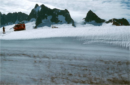
Northwest-looking oblique aerial photograph showing
part of the higher elevation accumulation area of
the Fairweather Range, Glacier Bay National Park,
Alaska. |
Accumulation Area
The part of a glacier that is perennially covered with snow. Also called Névé.
|

Northeast-looking oblique aerial photograph showing
the snow-covered summit accumulation area of Mount
Fairweather, Fairweather Range, Glacier Bay National
Park, Alaska. |
|
|

Northeast-looking oblique aerial photograph showing
the east margin of the Taku Glacier advancing into
the adjacent forest, Juneau Icefield, Tongass National
Forest, Alaska. The foreground field of view is
slightly more than 1/4 mile wide. |
Advance
An increase in the length of a glacier compared to
a previous point in time. As ice in a glacier is always
moving forward, a glacier's terminus advances when less
ice is lost due to melting and/or calving than the amount
of yearly advance.
|

July 1994 northwest-looking photograph showing part
of a push moraine formed by the advance of a spatulate
finger of advancing glacier ice, during the 1993-1995
surge of Bering Glacier, Chugach Mountains, AK.
Bering Glacier flows through Wrangell-Saint Elias
National Park. |
|

A northwest-looking photograph showing the west
margin of the Meares Glacier in September 2000,
which advanced into the adjacent forest and knocked
down a mature Sitka Spruce, Unakwik Inlet, Prince
William Sound, Chugach National Forest, Alaska. |
|
|

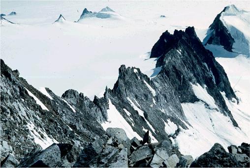
Southwest-looking oblique aerial photograph showing
a number of glacier valleys separated by angular
arete ridges, northeastern Juneau Icefield adjacent
to the Alaska - Canada Border, Coast Mountains,
Alaska. |
Arête
A jagged, narrow ridge that separates two adjacent glacier
valleys or cirques. The ridge frequently resembles the blade
of a serrated knife. A French term referring to the bones
in a fish backbone.
|

North-looking oblique aerial photograph showing
the shadow of an angular arete ridge on the south
side of the Bagley Ice Valley, Bering Glacier, Wrangell-Saint
Elias National Park, Alaska. |
|
West-looking photograph showing an angular arete
ridge, composed of schist, on the upper Taku Glacier,
Juneau Icefield, Tongass National Forest, Coast
Mountains, Alaska. |
|
|
|