For definitions of Ice Cap, Ice Field and Icesheet
see Glacier
Types |
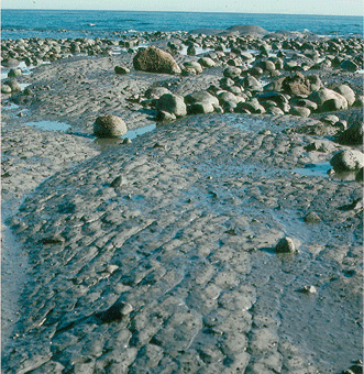
South-looking photograph showing an outcrop of the
Miocene age Yakataga Formation, Gulf of Alaska shoreline,
Glacier Bay National Park, Alaska. The unit consists
of ice-transported sand to boulder-size coarse-grained
sediment in a glacial silt matrix. |
Ice Rafting
The transportation of glacier sediment away from the ice
margin by icebergs. Sediment transported by floating ice and
deposited in the ocean is called glacial-marine sediment.
Deposited in lakes, it is called glacial-lacustrine sediment.
|
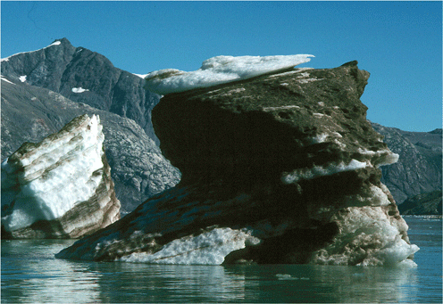
North-looking photograph showing two icebergs that
are transporting significant quantities of glacially-eroded
sediment, Johns Hopkins Inlet, Glacier Bay National
Park, Alaska. As these icebergs melt and roll-over,
the entrained sediment will be released into the
water column. |
|
|
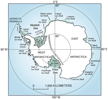
USGS map of Antarctica showing the location of ice
shelves in darker blue from Fact
Sheet 050-98. |
Ice Shelf
The floating terminus of a glacier, typically formed when
a terrestrial glacier flow into a deep water basin, such as
in Antarctica and the Canadian Arctic.
|
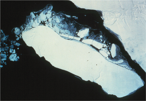
LANDSAT MSS image of a large iceberg separating
from the Larsen Ice Shelf. The berg is more than
50 miles long. |
|
|
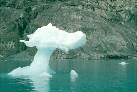
North-looking photograph showing an iceberg shaped
like a dragon, towering ~ 15 feet above the waters
of Muir Inlet, Glacier Bay National Park, Alaska. |
Iceberg
A block of ice that has broken or calved from the face of
a glacier and is floating in a body of marine of fresh water.
Alaskan icebergs rarely exceed 500 feet in maximum dimension.
In order of increasing size, the following names are used:
Brash Ice, Growler, Bergy Bit.
|
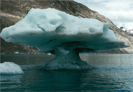
North-looking photograph showing an iceberg shaped
like a mushroom, towering ~ 15 feet above the waters
of Muir Inlet, Glacier Bay National Park, Alaska. |
|

North-looking photograph showing 300+-foot-long
iceberg towering more than 40 feet above the waters
of Portage Lake, Chugach National Forest, Chugach
Mountains, Alaska. |
|
Near vertical aerial photograph of the southwest
coast of Greenland (upper right) flanked by a large,
dense field of drifting icebergs. Most icebergs
are less than 400 feet in maximum length, but the
large berg in the upper left is at least 1/4-mile
in length. |
|
|
Ice-Dammed Lake
A lake that exists because its water is restricted from flowing
by an ice dam. Sometimes these lakes form because an advancing
glacier had blocked a valley.

Northeast-looking oblique aerial photograph showing
the floor of a recently drained, ice-dammed lake,
a part of Berg Lake, Chugach National Forest,
Chugach Mountains, Alaska. The numerous sub-circular
depressions on the lake floor suggest that the
floor of the lake is ice-cored. As this part of
the glacier's terminus thinned and narrowed,
the lake was able to drain around the perimeter
of the lake. This lake is an ice-marginal lake.
|
|
|
Icefall
Part of a glacier where the ice flows over a bed with a very
steep gradient, typically at a higher rate than both above
and below. As a result the surface is fractured and heavily
crevassed. In a river system, this would be a waterfall.
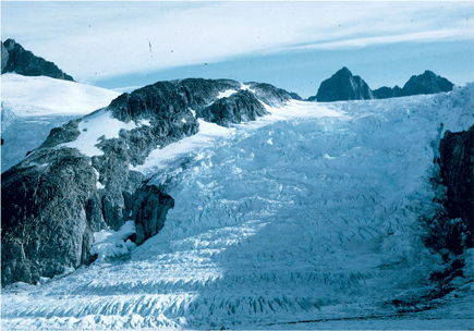
Northwest-looking photograph of the Vaughn Lewis
Icefall, a steep, > 1,500 foot bedrock cliff
over which the Vaughn Lewis Glacier descends from
the upper Juneau Icefield, Tongass National Forest,
Alaska. |
|
|
Ice-Marginal Lake
A lake that is located adjacent to the terminus of a glacier.
Typically, these lakes form in bedrock basins scoured by
the
glacier. They enlarge as the glacier retreats. Sometimes
they are dammed by an End or Recessional Moraine.
North-looking oblique aerial photograph showing
Harlequin Lake, an ice-marginal, moraine-dammed
lake, located adjacent tot the terminus of Yakutat
Glacier, Tongass National Forest, Saint Elias
Mountains, Alaska. The Dangerous River is the
meandering stream that drains the Lake at the
lower left. |
|
|
Isostasy
The balance between changes within the Earth's crust and
mantle, where material is displaced in response to an increase
(isostatic depression) or decrease (isostatic rebound) in
mass at any point on the Earth's surface above. Such changes
are frequently caused by advances or retreats of glaciers.
|
|
|