Mass Balance
A measure of the change in mass of a glacier at a certain
point for a specific period of time. The balance between
accumulation
and ablation. Also called Mass Budget.
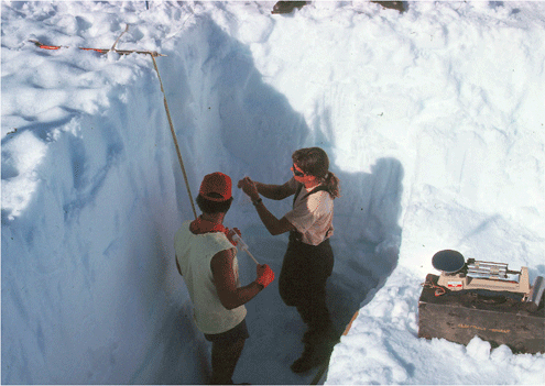
July 1979 photograph of a 12-foot deep snow pit
dug into the 1978-1979 thick snow accumulation
that fell on the surface of the Taku Glacier,
Juneau Icefield, Tongass National Forest, Coast
Mountains, Alaska. The thickness and density of
the new snow is being measured to determine its
volume and water content, as well as to study
its metamorphism to glacier ice. |
|
|
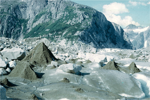
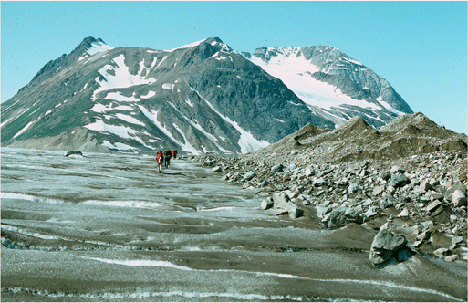
August 1968 southwest-looking photograph of the
surface of the Bucher Glacier, an outlet glacier
of the Juneau Icefield, showing several glacier
tables, several conical mounds of sediment-covered
ice, and several small piles of sediment left on
the ice surface marking the position of former mounds,
Coast Mountains, Tongass National Forest, Alaska. |
Moraine
A general term for unstratified and unsorted deposits of
sediment that form through the direct action of, or contact
with, glacier ice. Many different varieties are recognized
on the basis of their position with respect to a glacier.
|

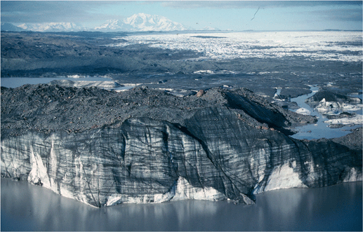
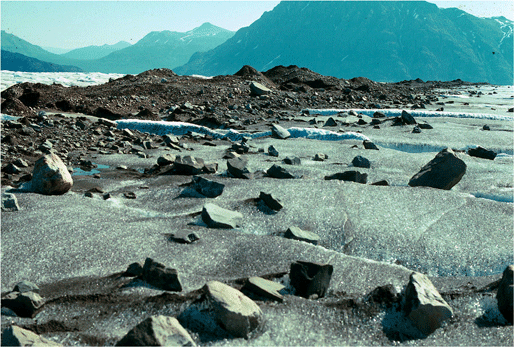
August 1997 north-looking oblique aerial photograph
of the moraine-covered surface of part of the stagnant
terminus of the Malaspina Glacier, Wrangell-Saint
Elias National Park, Saint Elias Mountains, Alaska.
The maximum sediment thickness exceeds 3 feet. |
|
|
|
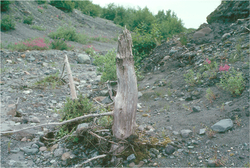
·Ablation Moraine
An irregular-shaped layer or pile of glacier sediment formed
by the melting of a block of stagnant ice. Ultimately, ablationa
moraine is deposited on the former bed of the glacier. Also
called Ablation Till.
August 1997 north-looking oblique aerial photograph
of the moraine-covered surface of a stagnant piece
of the former terminus of the Malaspina Glacier,
Wrangell-Saint Elias National Park, Saint Elias
Mountains, Alaska. The ice mass is more than 1/4
mile long and has a maximum sediment thickness
exceeding 3 feet. |
|
|
|
·Ground Moraine
A blanket of glacier till deposited on all of the surfaces
over which a glacier moves, typically by moving ice.
North-looking, July 1998, photograph showing about
a pair of glacially-sheared trees growing on a
till-covered surface, Bering Glacier, Chugach
National Forest, Chugach Mountains, Alaska. Bering
Glacier flows through Wrangell-Saint Elias National
Park. |
|
|
|
·Ice-cored Moraine
A moraine ridge consisting of a drape of sediment overlying
a mass of stagnant ice.
July 1968 northeast-looking photograph of the
moraine covered surface of a large mass of stagnant
ice, formerly part of the lateral moraine of the
Herbert Glacier, Juneau Icefield, Coast Mountains,
Tongass National Forest, Alaska. Note the person
to the upper left of the exposed ice, for scale. |
|
|
|
·Lateral Moraine
A sediment ridge, located on a glaciers surface adjacent
to the valley walls, extending down glacier to the terminus.
It forms by the accumulation of rock material falling onto
the glacier from the valley wall, rather than by water deposition.
September 2000 northwest-looking oblique aerial
photograph of an Talkeetna Glacier, showing a
well preserved former lateral moraine towering
above the surface of the rapidly thinning and
retreating glacier. The moraine is more than 200
feet high, southeast Talkeetna Mountains, Alaska. |
|
|
July 1968 north-looking oblique aerial photograph
of the confluence of the Gilkey and Bucher Glacier,
showing numerous medial moraines and a pair of lateral
moraines joining to form the large medial moraine
in the foreground, Juneau Icefield, Coast Mountains,
Tongass National Forest, Alaska. |
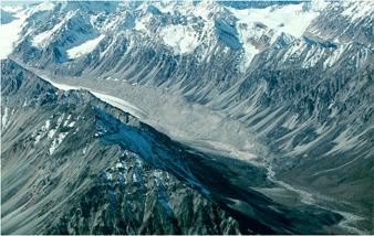
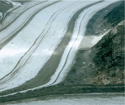
·Medial Moraine
A sediment ridge, located on a glaciers exposed ice surface,
away from its valley walls, extending down glacier to the
terminus. It forms by the joining of two lateral moraines
when two glaciers merge.
|
July 1978 north-looking photograph showing a large,
poorly sorted medial moraines on the surface of
the Llewellyn Glacier, Juneau Icefield, Coast Mountains,
British Columbia, Canada. |
|
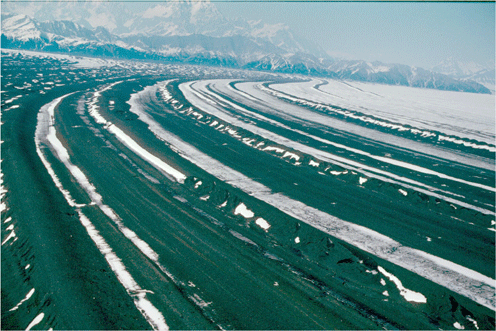
July 1998 northeast-looking oblique aerial photograph
showing a number of the large loop moraines, a series
of folded medial moraines on the surface of the
Malaspina Glacier, Wrangell-Saint Elias National
Park, Saint Elias Mountains, Alaska. Individual
moraines are more than 20 miles in length and up
to 1/8 mile wide. Maximum sediment thickness exceeds
20 feet. |
|
July 1968 south-looking photograph of a medial moraine,
located on the surface of the Bucher Glacier, Juneau
Icefield, Coast Mountains, Tongass National Forest,
Alaska. The angular boulders are a lag deposit from
an earlier time when the medial moraine was thicker
and wider. |
|
|
|
·Push Moraine
A ridge or pile of unstratified glacial sediment that is
formed in front of the ice margin by the terminus of an advancing
glacier, bulldozing sediment in its path.
August 1989 north-looking photograph of a five-foot-high
push moraine formed by an advance of Harriman
Glacier, Harriman Fiord, Chugach National Forest,
Prince William Sound, Alaska. The moraine had
a horizontal extent of ~ 350 ft. |
|
|
|
·Recessional Moraine
A ridge of glacial sediment that forms when the terminus
of a retreating glacier remains at or near a single location
for a period of time sufficient for a cross-valley accumulation
to form.

September 2002 northeast-looking oblique aerial
photograph of a > 100-foot-high moraine formed
by a retreating unnamed glacier, Harris Peninsula,
Kenai Fjords National Park, Kenai Mountains, Alaska.
An end moraine is located ~ .5 mile down valley
from this moraine, off the photograph to the lower
left. |
|
|
|
·Terminal Moraine
A cross-valley, ridge-like accumulation of glacial sediment
that forms at the farthest point reached by the terminus
of
an advancing glacier. Also called an End Moraine.
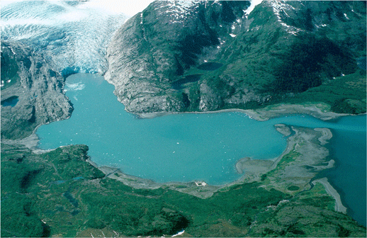
September 2002 north-looking oblique aerial photograph
of Nellie Juan Glacier and the 2-mile-long, seawater-filled
lagoon, exposed by the 20th century retreat of
the glacier. The east end of the lagoon is contained
by an arcuate terminal moraine formed during the
first quarter of the 20th century, Port Nellie
Juan, Chugach National Forest, Prince William
Sound, Alaska. |
|
|
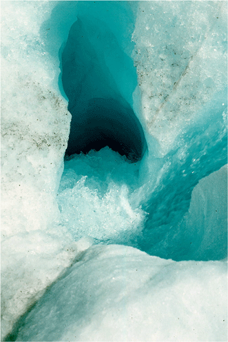
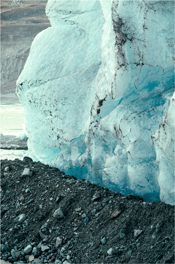
July 1988 near vertical photograph looking into
the top of a moulin, located on the surface of the
Malaspina Glacier, Wrangell-Saint Elias National
Park, Saint Elias Mountains, Alaska. This moulin
is more than 2 feet in diameter and penetrated more
than 20 feet before it changed direction. |
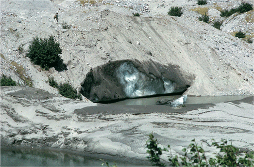
Moulin (Glacier Mill)
A narrow, tubular chute or crevasse through which water enters
a glacier from the surface. Occasionally, the lower end of
a moulin may be exposed in the face of a glacier or at the
edge of a stagnant block of ice.
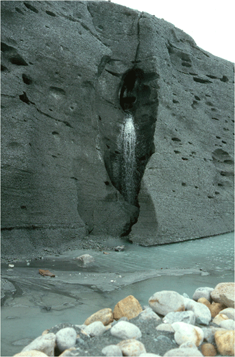
August 1976 northeast-looking photograph of a moulin,
exposed in longitudinal section, at the terminus
of LaPerouse Glacier, St Elias Mountains, Glacier
Bay National Park, Alaska. |
|
|
|