Glacial Groove/Glacial Furrow
A linear depression, inches to miles in length, produced
by the removal of rock or sediment by the erosive action of
a glacier.
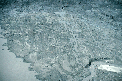
August 1996 north-looking oblique aerial photograph
of a recently-exposed area adjacent to the terminus
of the Bering Glacier, the largest Alaskan glacier,
located east of Cordova. Features present include
numerous parallel glacial grooves and furrows,
several eskers, and several recessional moraines.
The debris-covered glacier terminus is at the
top edge of the photograph. From left to right,
the field of view is ~ 1.5 miles across. Bering
Glacier flows through Wrangell-Saint Elias National
Park. Chugach Mountains, Alaska. |
|
|
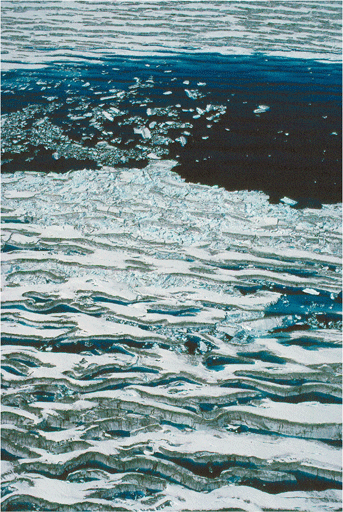
July 1995 oblique aerial photograph of part of a
semi-circular, blue water, supra-glacial lake on
the surface of Bering Glacier. The part of the lake
in the foreground consists of numerous water-filled,
snow-covered crevasses. The lake formed during the
1993-95 surge of the glacier. The lake has a diameter
of ~ 1/4 mile. Bering Glacier flows through Wrangell-Saint
Elias National Park. Chugach Mountains, Alaska. |
Glacial Lake
An accumulation of standing liquid water on (supraglacial),
in (englacial), or under (subglacial) a glacier.
|
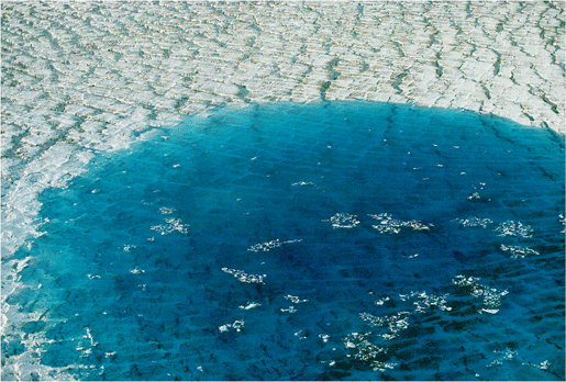
July 1995 oblique aerial photograph of most of a
circular, blue water, supra-glacial lake on the
surface of Bering Glacier, the largest Alaskan glacier,
located east of Cordova. The lake formed during
the 1993-95 surge of the glacier. The lake has a
diameter of ~ .5 miles. Bering Glacier flows through
Wrangell-Saint Elias National Park. Chugach Mountains,
Alaska. |
|
|
Southeast-looking photograph of a subglacial stream
discharging from the terminus of Harriman Glacier,
Chugach National forest, Prince William Sound, Alaska.
The width of the stream channel is ~ 50 ft. |
Glacial Stream
A channelized accumulation of liquid water on (supraglacial),
in (englacial), or under (subglacial) a glacier, moving under
the influence of gravity.
|
Photograph of a subglacial stream discharging from
beneath Reid Glacier, Glacier Bay National Park,
Alaska. Note the blue ice, and the natural levee
on the right bank of the stream. |
|
|
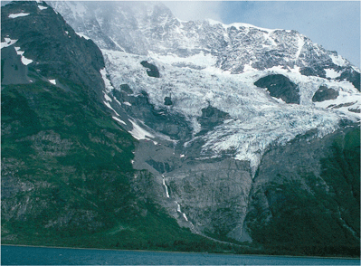
Northwest-looking photograph of the terminus of
Roaring Glacier, a hanging glacier, located in Harriman
Fiord, Prince William Sound, Alaska. Almost all
of this glacier is experiencing ablation. Note the
large bare bedrock area, located below the terminus.
This area was exposed by glacier retreat during
the 20th century. |
Glacier
A large, perennial accumulation of ice, snow, rock, sediment
and liquid water originating on land and moving down slope
under the influence of its own weight and gravity; a dynamic
river of ice. Glaciers are classified by their size, location,
and thermal regime.
|

North-looking oblique aerial photograph of the lower
reaches of an unnamed Alaskan valley glacier, informally
known as Five Stripe Glacier, showing lateral and
medial moraines, trimlines, outwash sediment, the
firn line, and many other related glacial features,
Chugach Mountains, Alaska. Both ablation and accumulation
areas are shown. |
|
|
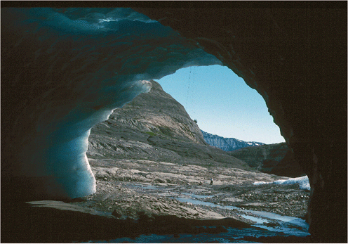
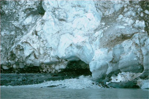
Southwest-looking photograph of the mouth of a subglacial
ice cave at the terminus of a large remnant of glacier
ice, separated from the retreating Guyot Glacier,
near Icy Bay. This cave was formerly a subglacial
stream channel. The width and height of the cave
are both ~ 25 ft. Wrangell - St Elias National Park,
St Elias Mountains, Alaska. |
Glacier Cave
A cave formed in or under a glacier, typically by running
water. Steam or high heat flow can also form glacier caves.
Also called Ice Cave.
|
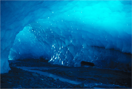
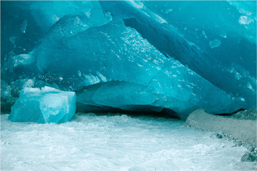
Northeast-looking photograph of the interior of
a subglacial ice cave located at the base of a large
remnant of glacier ice, separated from the retreating
Guyot Glacier, near Icy Bay. This cave, formerly
a subglacial stream channel, still has a small stream
flowing on its floor. The width and height of the
cave are both ~ 25 ft, while its length is ~ 1/4
mile. Wrangell - St Elias National Park, St Elias
Mountains, Alaska. |
|
|

August 1994 near-vertical aerial photograph of part
of the surface of the Bering Glacier showing a number
of tightly folded and contorted crevasses. During
the 1993-1995 surge many complex flow features were
observed on the glacier's surface. Bering
Glacier flows through Wrangell-Saint Elias National
Park. Chugach Mountains, Alaska. The field of view
is ~ 1/8 mile. |
Glacier Flow
The movement of ice in a glacier, typically in a downward
and outward direction, caused by the force of gravity.
'Normal' flow rates are in feet per day. 'Rapid' flow
rates (i.e. surge) are in 10s or 100s of feet per day.
|

July 1994 near-vertical photograph of part of the
ground surface adjacent to the terminus of Bering
Glacier. The top several inches of moss- and algae-covered
sediment have been tightly folded and contorted
by the upward and right-ward push of the adjacent
ice. During the 1993-1995 surge many complex ice
push features were observed adjacent to the glacier.
Bering Glacier flows through Wrangell-Saint Elias
National Park. Chugach Mountains, Alaska. The field
of view is ~ 6 ft wide. |
|
|

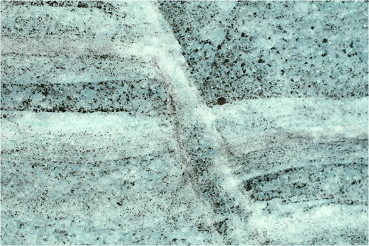
Northeast-looking photograph of the surface of Taku
Glacier showing a fault plane formed by thrust faulting.
The vertical offset is ~ 1 ft. The length of the
rupture was ~ 1/8 mile. Glacier ice experiences
the same types of deformation as other rock types.
The field of view from top to bottom is ~ 45 ft.
Juneau Icefield, Tongass National Forest, Alaska. |
Glacier Ice
A mono-mineralic type of rock, composed of crystals of the
mineral ice, formed through metamorphism of snowflakes.
Metamorphism
results in recrystallization, increased density, and the
growth of hexagonal crystals. This ice comprises the majority
of
the mass of a glacier. Intermediate stages include Firn and
Névé.
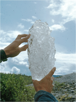
Photograph of a large melting ice crystal, collected
at the terminus of the Mendenhall Glacier. This
crystal had a length of ~ 1 ft. Juneau Icefield,
Tongass National Forest, Alaska. |
|
Northeast-looking photograph of the surface of Taku
Glacier showing a fault plane formed by normal faulting.
The horizontal offset is ~ 2 ft. The length of the
rupture was ~ 100 ft. Glacier ice experiences the
same types of deformation as other rock types. The
field of view from top to bottom is ~ 3 ft. Juneau
Icefield, Tongass National Forest, Alaska. |
|
|
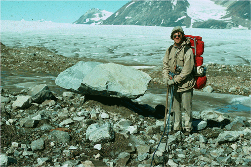
Northwest-looking photograph of the surface of the
Vaughn Lewis Glacier showing a glacier table formed
by differential melting. The angular granodiorite
boulder that makes the table top is ~ 4 ft-long.
Juneau Icefield, Tongass National Forest, Alaska. |
Glacier Table
A rock that is balanced on a pedestal of ice, and elevated
above the surface of a glacier. The rock protects the pedestal
of ice from melting by insulating it from the sun.
|

North-looking photograph of part of the surface
of Bering Glacier showing a glacier table formed
by differential melting. The angular crystalline
boulder that makes the table top is ~ 10 ft-long.
Wrangell-Saint Elias National Park. Chugach Mountains,
Alaska. The field of view is ~ 40 ft wide. |
|
|
|