Debris Cone
A cone or mound of debris-covered ice, with a thick
enough sediment cover to protect the ice from melting.

Southeast-looking photograph showing four conical
debris cones sitting on the ablating surface of
the Bucher Glacier, adjacent to its confluence
with the Gilkey Glacier, Juneau Icefield, Tongass
National Forest, Coast Mountains, Alaska. The
tallest of the cones is ~ 4 m high. The debris
cones' sediment accumulated in a crevasse. |
|
|
Dendrochronology
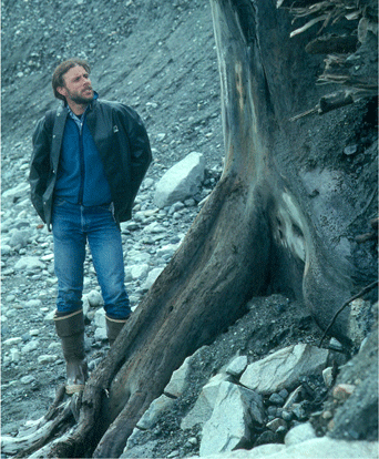
Photograph of the exposed roots and lower trunk
of a tree that has recently eroded out of its entraining
glacial sediment, Muir Inlet, Glacier Bay National
Park, Alaska. The top of the tree was sheared off
by an advance of Muir Glacier ~ 8,000 years ago. |
The study of tree rings and subfossil wood to provide information
about the glacial and climatic history of an area.
|
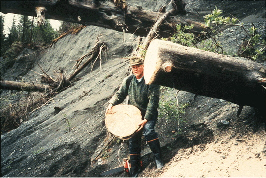
Photograph of several exposed tree trunks, recently
eroded out of glacial-lacustrine sediment, south
of the eastern margin of Bering Glacier, Alaska.
The slab of wood that was cut from the tree in the
foreground will have its rings analyzed and will
have samples of individual rings radiocarbon dated.
The tree was sheared off by an advance of Being
Glacier ~ 1,500 years ago. Photograph by Austin
Post. Bering Glacier flows through Wrangell-Saint
Elias National Park. |
|
|
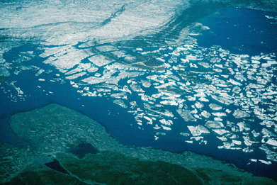
September 10, 2001 LANDSAT 7 TM image showing a
large disarticulation event occurring at Bering
Glacier, Coast Mountains, Alaska. The width of the
disarticulation area is ~ 1.0 mile. |
Disarticulation
Disarticulation is the process through which large
blocks of ice, sometimes greater than .5 miles in width,
detach from the thinning and retreating terminus of
a glacier that ends in a body of water. Disarticulation occurs as
the terminus thins to
where its buoyandcy no longer permits it to remain in
contact with its bed. As the glacier begins to float
free and rises off the bottom it rapidly comes apart
along old fracture scars and crevasses. For example,
at Bering Glacier, in the Chugach Mountains, Alaska, a single
observed disarticulation event resulted in nearly 2/3
of a mile of terminus retreat in a single day. As many
as 100 discrete, tabular pieces of glacier ice have
been observed separating from the glacier's terminus
in a single event. Bering Glacier flows through Wrangell-St.
Elias National Park, Alaska.
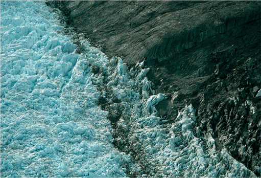
Northeast-looking oblique aerial photograph of
a large disarticulation event occurring at Bering
Glacier, Coast Mountains, Alaska in August 2001.
The width of the disarticulation area is ~ 1.0
mile. This is the same location shown in the LANDSAT
image below. |
|
|
Distributary
A tongue of glacier ice that flows away from the main trunk
of the glacier. This may result from differential melting
changing the gradient of part of a glacier.
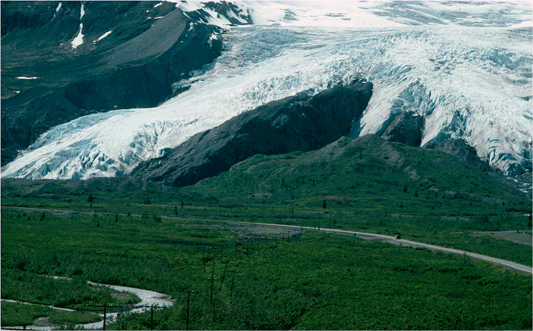
Southwest-looking photograph of the terminus of
Worthington Glacier, showing several small distributaries
diverging from the main trunk of the glacier,
Chugach National Forest, Chugach Mountains, Alaska. |
|
|
Downwasting
The thinning of a glacier due to the melting of ice. This
loss of thickness may occur in both moving and stagnant
ice. Also called Thinning.
Northeast-looking near-vertical aerial photograph
of the east margin of Muir Glacier. Both debris-covered
and bare pieces of ice are sitting on recently-exposed
bedrock adjacent to the glacier margin. The ice
at the right edge of the photograph was stranded
by the rapid thinning of the glacier, Muir Inlet,
St Elias mountains, Glacier Bay National Park,
Alaska. |
|
|
Drift
A collective term used to describe all types of glacier
sedimentary deposits, regardless of the size or amount of
sorting. The
term includes all sediment that is transported by a glacier,
whether it is deposited directly by a glacier or indirectly
by running
water that originates from a glacier.

North-looking near-vertical aerial photograph
of a 1-mile by 1.5-mile area recently-exposed
by the retreat of Bering Glacier. The ground surface
is covered by glacial sediment deposited in several
ways, including as lodgement and ablation till,
and as crevasse fill, Bering Glacier, Alaska.
Bering Glacier flows through Wrangell-Saint Elias
National Park. |
|
|
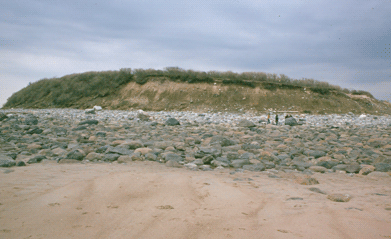
Photograph of the flank of a drumlin composed of
glacial till. The length of this drumlin is ~ 1/8
mile. Note the two people for scale. Cranes Beach,
MA. |
Drumlin
An elongated ridge of glacial sediment sculpted by ice moving
over the bed of a glacier. Generally, the down-glacier end
is oval or rounded and the up-glacier end tapers. The shape
is often compared to an inverted, blunt-ended canoe. Although
not common in Alaska, drumlins cover parts of the Eastern
and Midwestern United States (Irish).
|
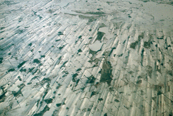
North-oblique aerial photograph of the fluted and
drumlin-covered landsurface, north of Milwaukee,
WI. The field of view is ~ 7 by 18 miles. |
|
|
|