Nunatak
A mountain peak or ridge that pokes through the surface
of an Ice Field or a Glacier. It may separate
adjacent Valley
Glaciers (Greenlandic).

Northeast-looking photograph showing a well-formed
sharp-peaked horn and connected arete ridge. The
horn which pokes through the snow-covered Juneau
Icefield is a nunatak, Tongass National Forest,
Alaska. |
|
|

North-looking oblique aerial photograph of the upper
reaches of Sea Otter Glacier, Fairweather Range,
Glacier Bay National Park, Alaska. The surface of
each of the glacier's main tributaries contains
several dozen band ogives. |
Ogive
An arcuate, convex, down-glacier-pointing band or undulation
that forms on the surface of a glacier at the base of
an icefall. Two types of ogives occur: wave ogives,
which are undulations of varying height and band
ogives, which are alternating light- and dark-colored
bands.
|

Southwest-looking photograph of the surface of the
Vaughn Lewis Glacier, immediately below the Vaughn
Lewis Icefall, Juneau Icefield, Tongass National
Forest, Alaska. The surface of the central part
of the glacier contains more than a dozen wave ogives. |
|
|

Northwest-looking oblique aerial photograph of the
terminus of Brady Glacier, Fairweather Range, Glacier
Bay National Park, Alaska, which is fronted by a
braided outwash plain that extends for > 4 miles.
The surface is fed by numerous ice-marginal streams. |
Outwash plain
A broad, low-slope angle alluvial plain composed of glacially
eroded, sorted sediment (termed outwash), that has been
transported
by meltwater. The alluvial plain begins at the foot of a
glacier and may extend for miles. Typically, the sediment
becomes
finer grained with increasing distance from the glacier terminus.
|

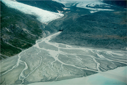
Northwest-looking oblique aerial photograph of the
stagnant terminus of Rendu Glacier, Fairweather
Range, Glacier Bay National Park, Alaska, showing
a braided outwash plain fan delta that originates
from a subglacial stream on the west side of the
glacier. |
|
|
|

