Types of Glaciers:
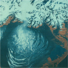
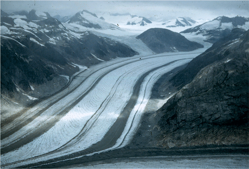
July 1986 LANDSAT TM image of the terminus of Hubbard
Glacier at the head of Yakutat Bay, Wrangell - St
Elias National Park, Alaska. At the time that this
digital image was made, the glacier's terminus was
blocking the entrance to Russell Fiord. Image from
USGS EROS Data Center. |
·Calving Glacier
A glacier with a terminus that ends in a body of water (river,
lake, ocean) into which it calves icebergs.
|
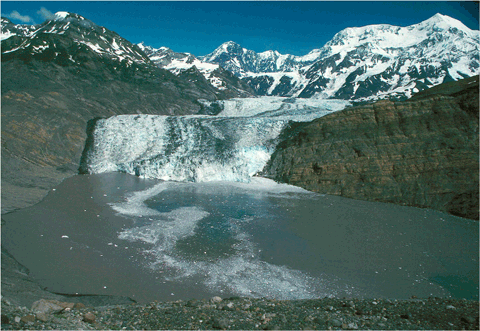
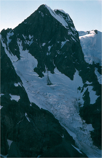
Photograph of the calving terminus of Tyndall Glacier,
located at the head of Taan Fiord, Icy Bay, Wrangell
- St. Elias National Park, Alaska. The large mountain
to the right is Mt. St. Elias. |
|
|
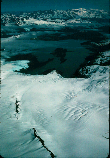
·Cirque glacier
A small glacier that forms within a cirque basin, generally
high on the side of a mountain.
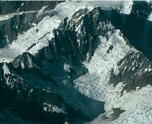
Northeast-looking oblique aerial photograph showing
a small, unnamed cirque glacier located on the
south flanks of Mount Fairweather, Fairweather
Range, Glacier Bay National Park, Alaska. |
|
|
North-looking oblique aerial photograph showing
a small, unnamed hanging glacier located in the
Chugach Mountains, near Cordova Peak, Chugach National
Forest, Alaska. |
·Hanging glacier
A glacier that originates high on the wall of a glacier valley
and descends only part of the way to the surface of the main
glacier. Avalanching and icefalls are the mechanisms for ice
and snow transfer to the valley floor below.
|
Northeast-looking photograph showing three small,
unnamed hanging glaciers descending to the surface
of the Vaughn Lewis Glacier, Juneau Icefield, Tongass
National Forest, Coast Mountains, Alaska. |
|
Northwest-looking oblique aerial photograph showing
several small, unnamed hanging glaciers located
in the Chugach Mountains, near Cordova Peak, Chugach
National Forest, Alaska. Only the hanging glacier
in the center of the photograph reaches the debris-covered
glacier on the valley floor. |
|
|
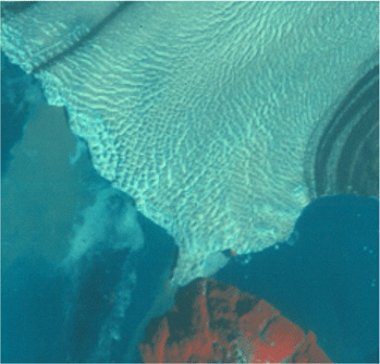
North-looking NOAA AVHRR satellite image of the
western side of the Greenland Ice Cap. The body
of water west of Greenland is Baffin Bay. |
·Ice Cap
A dome-shaped accumulation of glacier ice and perennial
snow that completely covers a mountainous area or island,
so that
no peaks or Nunataks poke through.
|
|
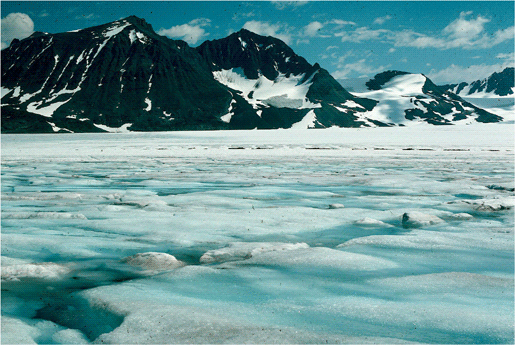
North-looking oblique aerial photograph of an unnamed,
snow-covered ice field, located on the south side
of Blackstone Bay, Kenai Mountains, western Prince
William Sound, Chugach National Forest, Alaska. |
·Ice Field
A continuous accumulation of snow and glacier ice that completely
fills a mountain basin or covers a low-relief mountain plateau
to a substantial depth. When the thickness become great enough,
tongues of ice overflow the basins or plateaus as Valley
Glaciers.
|
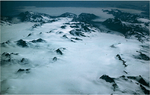
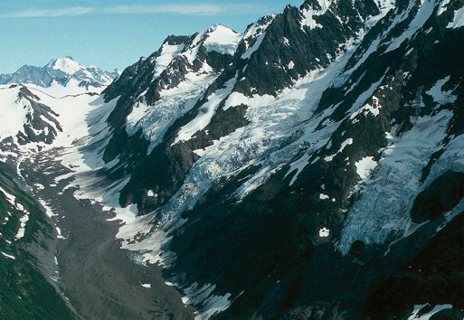
South-looking oblique aerial photograph of the Harding
Ice Field, Kenai Fjords National Park, Kenai Mountains,
Alaska. The cloud-covered Gulf of Alaska is at the
top of the photograph. |
|
|
·Ice Sheet
A thick, subcontinental to continental-scale accumulation
of glacier ice and perennial snow that spreads from a center
of accumulation, typically in all directions. Also called
a Continental Glacier.
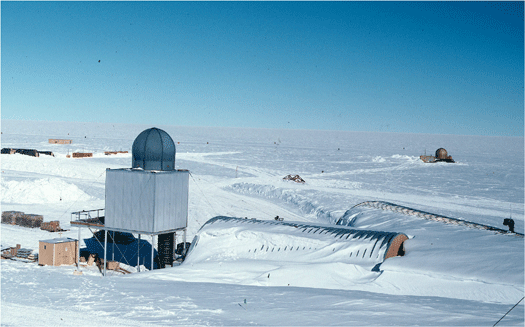
North-looking photograph across the Antarctic
Ice Sheet. In the foreground are some of the research
facilities located at the Amundsen-Scott South
Pole Station, South Pole Antarctica. |
|
|
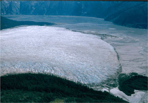
July 1985 LANDSAT TM image of the part of the piedmont
lobe terminus of Malaspina Glacier, located on the
west side of Yakutat Bay, Wrangell - St Elias National
Park, AK. At the time that this digital image was
made, only a small quantity of snow was present
on the glacier's terminus, hence many folded
moraines are visible. Image from USGS EROS Data
Center. |
·Piedmont glacier
A fan or lobe-shaped glacier, located at the front of a mountain
range. It forms when one or more valley glaciers flow from
a confined valley onto a plain where it expands. The 30-mile
wide Malaspina is the largest in Alaska.
|
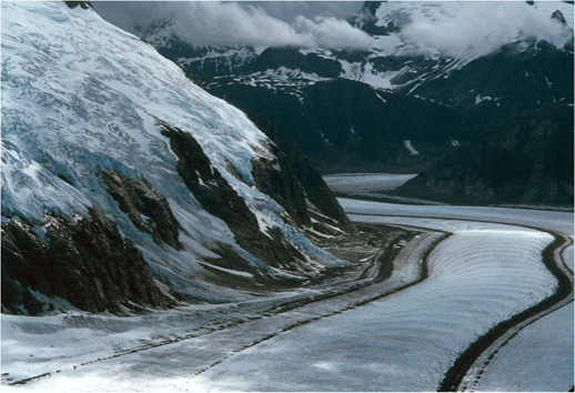
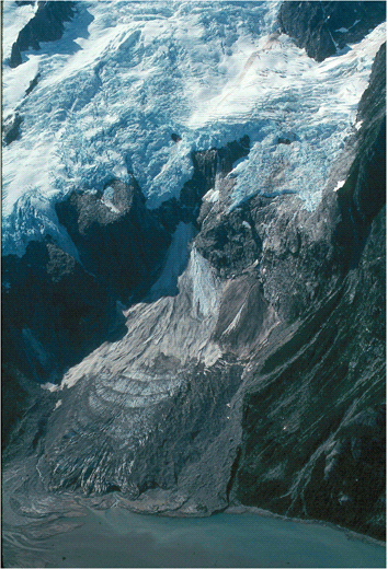
East-looking oblique aerial photograph of the piedmont
lobe terminus of the advancing Taku Glacier, located
in Taku Inlet, Coast Mountains, Tongass National
Forest, Alaska. The width of the glacier's terminus
is ~ 5 miles. |
|
|

December 1986 photograph of the author standing
at the South Pole, on the snow-covered surface of
the polar glacier that covers Antarctica. |
·Polar Glacier
A glacier with a thermal or temperature regime in which ice
temperatures always remain below the freezing point.
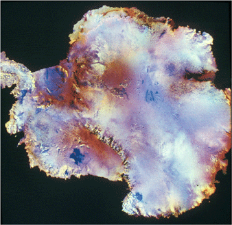
NOAA AVHRR satellite image of the Antarctica, showing
the polar glacier ice that covers more than 97%
of the continent. |
|
|
Southwest-looking oblique aerial photograph of the
reconstituted Ogive Glacier, located on the shore
of Northwestern Fjord, Kenai Fjords National Park,
Kenai Mountains, Alaska. |
·Reconstituted Glacier
A glacier formed below the terminus of a hanging glacier
by the accumulation, and reconstitution by pressure melting
(regelation), of ice blocks that have fallen and/or avalanched
from the terminus of the hanging glacier. Also called Glacier
Remanié.
|
North-looking photograph of several small unnamed
reconstituted glaciers, located at the head of Icy
Bay, Wrangell - St Elias National Park, St Elias
Mountains, Alaska. |
|
|
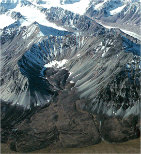
Northwest-looking oblique aerial photograph of an
unnamed rock glacier heading in a cirque, located
on the southeast side of the Talkeetna Mountains,
Alaska. |
·Rock Glacier
A glacier-like landform that often heads in a cirque and
consists of a valley-filling accumulation of angular rock
blocks. Rock glaciers have little or no visible ice at the
surface. Ice may fill the spaces between rock blocks. Some
rock glaciers move, although very slowly.
|
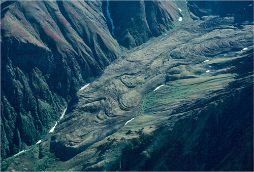
South-looking oblique aerial photograph of an unnamed
rock glacier with multiple flow lobes, located in
the Metal Creek drainage on the north side of the
Chugach Mountains, Alaska. |
|
|
·Temperate Glacier
A glacier with a or temperature-regime in which
liquid water coexists
with frozen water (glacier ice) during part or even all of
the year.
Northeast-looking photograph showing the stream
and pond covered-surface of the Taku Glacier,
Juneau Icefield, Tongas National Forest, Coast
Mountains, Alaska. |
|
|
·Tidewater Glacier
A glacier with a terminus that ends in a body of water
influenced by tides, such as the ocean or a large lake.
Typically, tidewater glaciers calve ice to produce icebergs.
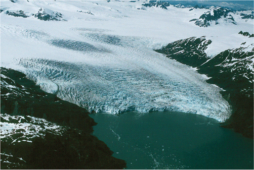
Northwest-looking oblique aerial photograph of
the tidewater terminus of the calving Chenega
Glacier, located at sea level in western Prince
William Sound, Kenai Mountains, Alaska. |
|
|
·Valley Glacier
A glacier that flows for all or most of its length within
the walls of a mountain valley. Also called an Alpine
Glacier or a Mountain Glacier.
Northeast-looking oblique aerial photograph of
the upper part of the Bucher Glacier, an outlet
glacier of the Juneau Icefield, Coast Mountains,
Tongass National Forest, Alaska. The length of
the glacier shown is ~ 5 miles. |
|
|
|