|
|
Discussion
Mixed Areas
|
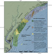
Figure 19. Map showing the four sea floor environments within Long Bay.
Click on figure for larger image.
|
The northern half of the survey area, with the exception of the shore-detached shoal offshore of Myrtle Beach and the inlet shoal complex offshore of Waites Island, is characterized by small-scale spatial variations in backscatter and bathymetry and surface sediments ranging from fine to coarse sand (figs. 4, 5 and 15). Where modern sediment is absent, Cretaceous strata and Pleistocene channel-fill deposits lie at, or near, the sea floor (fig. 2). These broad expanses of outcrop exhibit complex moderate to high backscatter patterns and coarse surface texture. Where modern sediment exceeds 0.5 m< in thickness, these strata locally appear within the trough and northern side of low-relief ridges (figs. 3 and 11). Uniform low-backscatter defines the fine to medium sand crest and southern face of these features (fig. 17). Offshore of Myrtle Beach (< 9-m water depth), wave-orbital ripples are observed within the coarse-grained, high-backscatter trough of smaller-scale, shore-normal, low-relief ridges (fig. 14). Little to no asymmetry is associated with these features.
The backscatter variations and grain size distribution of the shore-normal, low-relief ridges offshore of Myrtle Beach are similar to the sorted bedforms (previously, 'rippled scour depressions') mapped in other inner shelf environments (Thieler and others, 1995; Schwab and others, 2000; Goff and others, 2005). Murray and Thieler (2004) adopt the term 'sorted bedforms' to describe asymmetric, low-relief, shore-normal features offshore of Wrightsville Beach, N.C., and propose their development occurs by way of complex interactions between dominant along-shore flow (interaction of waves and currents) and poorly sorted bottom sediments. Gutierrez and others (2005) analyzed near-bed current measurements within the sorted bedforms offshore of North Carolina. Their findings support the work of Murray and Thieler (2004) and suggest that the differences in bed roughness within the coarse grained trough and finer grained crest are enhanced during strong wind and wave events. Increased turbulence inhibits deposition of fine sand within coarse grained areas, thus providing a mechanism for maintenance of the coarse to fine grained segregation characteristic of sorted bedforms (Grant and Madsen, 1986; Murray and Thieler, 2004).
Asymmetry was noted in the morphology of sorted bedforms mapped offshore of Martha's Vineyard (Goff and others, 2005), southern Long Island (Schwab and others, 2000), and North Carolina (Thieler and others, 2001), yet the shore-normal, low-relief ridges offshore of Myrtle Beach show no asymmetry (fig. 11). Additionally, varying thicknesses of mobile sediment were present within other inner shelf settings (Thieler and others, 1995; Schwab and others, 2000; Goff and others, 2005). Figure 13, shows that little to no modern sediment was mapped offshore of Myrtle Beach; the transgressive unconformity lies at the sea floor, capping Cretaceous strata and Pleistocene channel-fill deposits (Baldwin and others, 2004). The low-backscatter signature and fine grained texture of sediments sampled along the crest of the shore-normal, low-relief ridges is similar to the surficial character of modern sediment deposits throughout the survey area and may suggest the presence of a thin (< 0.5 m) layer of modern sediment that is below the resolution of the seismic systems.
The shore-normal, low-relief ridges appear to be influenced by modern nearshore processes, as evidenced by the presence of wave-orbital ripples, a common feature of the sorted bedforms (Thieler and others, 1995; Schwab and others, 2000; Goff and others, 2005). However, based on the thin to absent layer of modern sediment and the exposure of underlying geologic strata throughout the area, the general morphology and surficial character of these features appears to be mostly controlled by the underlying geology. If more sediment were available within the coastal system, sorted bedforms more characteristic of those mapped along the inner shelf of the U.S. Atlantic coast would likely develop.
Mixed areas show a range in sediment cover from no cover (i.e., exposed strata) to ~1 meter or greater. This variability is thought to reflect an increased temporal and spatial sediment flux as compared to the relatively stable shoal complexes (sediment accumulation) and hardground areas (erosion or non-deposition). Sediment flux is most likely driven by proximity to a source (i.e., shoals, shoreface, etc.), variability of nearshore hydrodynamics due to seasonal and climactic forcing, and location (i.e., proximity to inlets). Ongoing physical oceanographic studies will aid in defining the magnitude and temporal signature of sediment flux within these areas.
|

 Back to Previous Section
 Forward to Next Section