Figure 13 shows the regional geology for sub-area 3. The arrows shown on the figure point to Tertiary intrusive rocks that are interpreted using the Landsat and gamma-ray data. These arrows appear in each of the images presented as part of this discussion.
Figure 14 shows the image of Landsat bands 3, 2, and 1 as shades of red, green, and blue. This image is an approximation of how a normal color photograph of the area might look. The blue arrow points to intrusive rocks that are somewhat lighter in color and have blue-gray colors compared to the much darker rocks to which the red arrow points. The orange arrow points to intrusive rocks that are relatively reflective with brown overtones. The geologic map shows the intrusive corresponding to the blue arrow as scattered outcrops within rocks of the Aguja Formation (Kag). This image does not appear to be consistent with that interpretation because the roughly circular area suggests a continuous volume with perhaps thin remnants of the Aguja Formation. The intrusive corresponding to the orange arrow is shown as outcropping within the Javelina Formation (Kjf) but this image suggests a continuous volume of intrusive rocks with a thin cover of Javelina Formation.
Figure 15 shows the image of Landsat bands 5, 4, and 7 as shades of red, green, and blue. The blue arrow points to rocks that have distinctive blue and cyan colors in this image. The red arrow points to rocks that appear very dark brown or black. The orange arrow points to rocks that are mostly red-purple with some patches of blue and cyan pixels. In this image vegetation is red and a combination of red from vegetation with blue from the rocks might explain the red-purple color.
Figure 16 shows the color-ratio composite of Landsat band ratios 3/4, 3/1, and 5/7 as shades of red, green, and blue. The blue arrow points to rocks with variable colors that include some bright yellows. The dominant colors are blue, blue-gray, and magenta. The red arrow point to rocks that appear as red and magenta colors. This particular color seems to reflect the overall low reflectance of the rocks and can be easily confused with other dark areas such as the canyon along the Rio Grande River. The orange arrow points to rocks that are blue and cyan on the western side of the oval feature associated with the intrusive and are bright yellow on the eastern side of the feature.
Figure 17 shows the gamma-ray color-composite image with uranium, potassium, and thorium as shades of red, green, and blue. The flight lines from the regional survey are shown plotted on the image because very little data from the detailed survey have been used in this sub-area. Where some detailed data have been included is evident from the increased detail in the image. Because of the poor spatial resolution of the data care must be taken in the interpretation of the gamma-ray data. The blue arrow points to rocks that are relatively radioactive and the detail in the image suggests that the radioactive rocks are reasonably represented. Given that this is true, the area of more radioactive intrusive rocks is more that the geologic map indicates. The rocks to which the red arrow points appear to have low radioactivity but the detail within the image is only adequate to conclude that they are probably not significantly radioactive. The larger area of low radioactivity reflects the presence of Santa Elena Limestone (Kse). The orange arrow points to an area of diffuse radioactivity but the lack of detailed data does not allow us to characterize the rocks. We can conclude that some radioactive rocks are present in that area.
In sub-area 3 the darker rocks seen in Figure 15 are most likely basalt and represent feeder dikes and sills. The more radioactive rocks are likely silicic rocks. These data suggest that the blue arrow points to a volume of intrusive rock that may have a relatively thin cover. Certainly it is an area that merits a closer look when mapping. The feature indicated by the orange arrow is unclear and vegetation appears to be a confounding factor. The color-ratio composite does suggest that the eastern and perhaps southern areas of the feature are distinct from the western part. Field checks or some other type of data are needed to resolve the question.
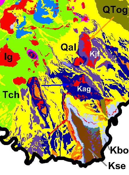
Figure 13. Geology for sub-area 3 from Maxwell and others (1967).
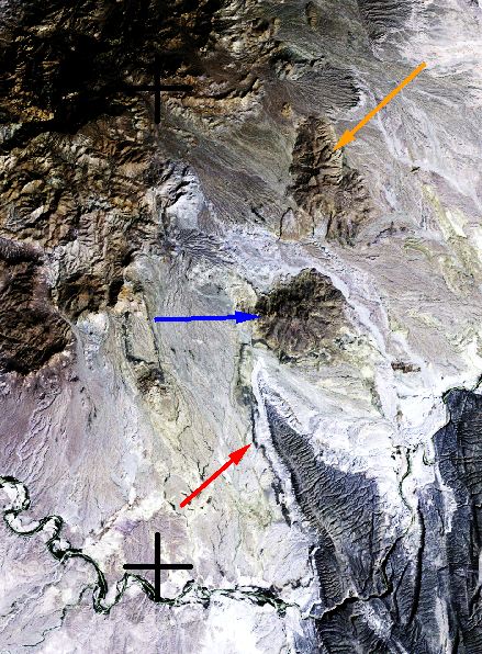
Figure 14. Sub-area 3 image of Landsat bands 3, 2, and 1 as shades of red, green, and blue.
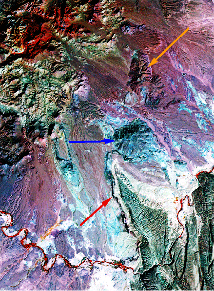
Figure 15. Sub-area 3 image of Landsat bands 5, 4, and 7 as shades of red, green, and blue.
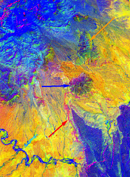
Figure 16. Sub-area 3 color-ratio composite of Landsat band ratios 3/4, 3/1, and 5/7 as shades of red, green, and blue.
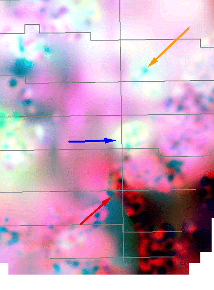
Figure 17. Sub-area 3 gamma-ray color-composite image with uranium, potassium, and thorium as shades of red, green, and blue.
Gamma-ray Data | Subarea Index | Subarea 1 | Subarea 2 | Subarea 3
Intro | Geology | Gamma-ray Data | Landsat Data | Maps | Conclusions | Listing of Data Files | References | Tutorial

![]() U.S. Department of the Interior |
U.S. Geological Survey
U.S. Department of the Interior |
U.S. Geological Survey
URL: http://pubsdata.usgs.gov/pubs/of/2005/1371/html/Subarea3.htm
Page Contact Information: Stephen Snyder
Page Last Modified: Saturday, 12-Jan-2013 21:45:17 EST