Figure 8 shows the regional geology for sub-area 2. The blue and red arrows shown on the figure point to Tertiary intrusive rocks that are interpreted using the Landsat and gamma-ray data. These arrows appear in each of the images presented as part of this discussion.
Figure 9 shows the image of Landsat bands 3, 2, and 1 as shades of red, green, and blue. This image is an approximation of how a normal color photograph of the area might look. Note that the blue arrows point to intrusive rocks that are lighter in color and have brown tones compared to the much darker rocks to which the red arrows point. The very dark colors indicate low reflectance from the rocks and suggest the presence of abundant dark minerals. The brown tones suggest the presence of visible iron oxides. The intrusive labeled 1 is not as dark as others to which red arrows point and this image alone does not suffice to make a determination that it is the same as the others. Similarly the intrusive labeled 2 might be considered different from other rocks to which blue arrows point. The blue arrow labeled 3 points to an intrusive that is tentatively assigned to the blue group mostly because it is more reflective although it has no obvious brown colors.
Figure 10 shows the image of Landsat bands 5, 4, and 7 as shades of red, green, and blue. The blue arrows point to rocks that have distinctive blue and cyan colors except the intrusive labeled 2 which has mostly brown colors. The red arrows point to rocks that appear very dark brown or black and the intrusive labeled 1 appears similar to others with red arrows. The intrusive labeled 3 does have dark blue colors but does not seem to belong to the blue group.
Figure 11 shows the color-ratio composite of Landsat band ratios 3/4, 3/1, and 5/7 as shades of red, green, and blue. The blue arrows point to rocks with distinctive blue-green colors and some of them have scattered red-orange pixels around them. The intrusive labeled 2 appears to be somewhat different largely because of the large areas of deep blue colors associated with it. It is likely that some of these areas of deep blue colors are caused by the presence of shadows. In this image the intrusive labeled 3 is quite different in appearance compared to other intrusives with blue arrows. The red arrows point to rocks that appear as darker blue colors in the image except for the intrusive in the upper left corner of the image which has abundant magenta pixels. This difference may be indicating difference in the rock type but vegetation differences may also be a factor. The images used to make this color-ratio composite are not perfectly balanced and the individual images are from different times of the year (October versus June).
Figure 12 shows the gamma-ray color-composite image with uranium, potassium, and thorium as shades of red, green, and blue. The blue arrows point to rocks that are much more radioactive except for the one labeled 3 which has overall low radioactivity. The rocks to which the red arrows point all have low radioactivity.
The description of the intrusive rocks given for the regional geologic map indicates that mafic and silicic rocks are present. The low gamma-ray signatures and the presence of dark minerals from the Landsat data indicate that the red arrows point to rocks that are most likely mafic. Most of the blue arrows point to rocks that are much more radioactive and also more reflective (indicating a greater abundance of quartz and other light-colored minerals) and such a signature indicates the presence of silicic rocks. The gamma-ray data indicate that the intrusive labeled 2 clearly does belong to the blue group but the one labeled 3 just as clearly does not and is probably basalt. The intrusive labeled 1 is an interesting target for field investigation because it is adjacent to a distinctly different intrusive. Field examination of the relationship between these different intrusive events might shed light on the relative ages of the rocks and could have implications for the relative ages of similar rocks in the area.
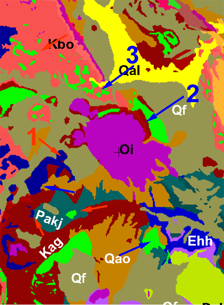
Figure 8. Regional geology for sub-area 2.
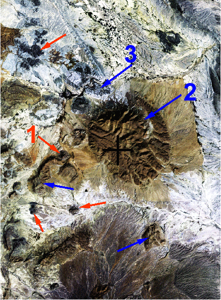
Figure 9. Sub-area 2 image of Landsat bands 3, 2, and 1 as shades of red, green, and blue.
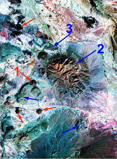
Figure 10. Sub-area 2 image of Landsat bands 5, 4, and 7 as shades of red, green, and blue.
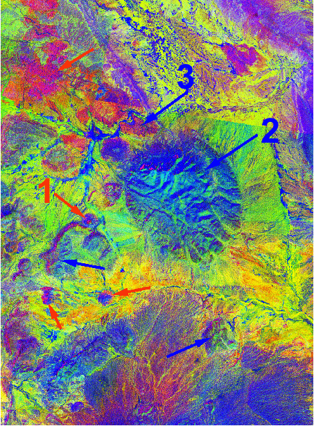
Figure 11. Sub-area 2 color-ratio composite of Landsat band ratios 3/4, 3/1, and 5/7 as shades of red, green, and blue.
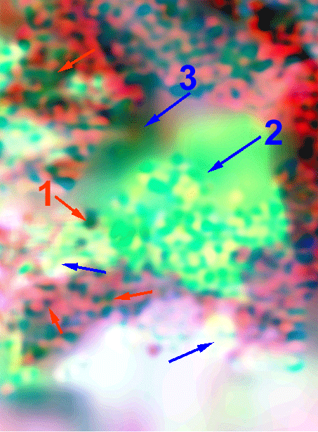
Figure 12. Sub-area 2 gamma-ray color-composite image with uranium, potassium, and thorium as shades of red, green, and blue.
Gamma-ray Data | Subarea Index | Subarea 1 | Subarea 2 | Subarea 3
Intro | Geology | Gamma-ray Data | Landsat Data | Maps | Conclusions | Listing of Data Files | References | Tutorial

![]() U.S. Department of the Interior |
U.S. Geological Survey
U.S. Department of the Interior |
U.S. Geological Survey
URL: http://pubsdata.usgs.gov/pubs/of/2005/1371/html/Subarea2.htm
Page Contact Information: Stephen Snyder
Page Last Modified: Saturday, 12-Jan-2013 21:45:16 EST