U.S. Geological Survey Open-File Report 2012-1234
Application of a Hydrodynamic and Sediment Transport Model for Guidance of Response Efforts Related to the Deepwater Horizon Oil Spill in the Northern Gulf of Mexico Along the Coast of Alabama and Florida
 |
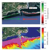
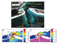
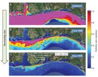
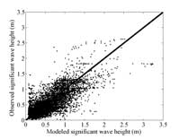
Implications of Results for Understanding SRB Formation, Burial, Exhumation, and TransportThe results of the numerical modeling allow specific conclusions to be drawn for a given time period of interest based on the scenario or on scenario-averaged results that indicate patterns in alongshore currents and their gradients, sediment and SRB mobility and potential transport, gradients, and complexities associated with tidal inlets under specific conditions. The results can be used to address many detailed questions; in this section, we identify and discuss some general findings that directly address the objectives of the OSAT3 subgroup. Alongshore-Currents and Gradients in TransportA primary objective of the OSAT3 subgroup effort was to identify regions of varying alongshore current speeds and directions, resulting in areas of persistent convergence and divergence of alongshore currents and, by inference, the deposition of SRBs. A striking example of convergence was detected in the model at Pensacola Pass where, because of the bend in the shoreline, alongshore flows and therefore potential SRB flux were directed toward the inlet (fig. 29). In this situation, SRBs occurring nearshore would be transported toward the inlet. This situation could lead to an increase in the complexity of SRB transport because waves, alongshore flows, and tidal currents would all interact with the sediment and SRBs. Inlet DynamicsInlet dynamics are complicated because they respond strongly to tidal- and storm surge-driven currents that affect both the inlet interior and open coast. These flows interact with a variety of morphological features including the sand spits at the inlet, ebb and flood delta shoals, sandbars and sand flats inside the inlet, and surf zone bars extending along the inlet spits (fig. 30). The interaction of morphology and tidal flow typically produces asymmetries in flow patterns that consist of strong flood tides in the channel, strong currents along the shoreline entering the inlet, and ebb flow jets that are focused by the channel. Hence, there can be a net tidal inflow along the shoreline. If SRBs exist along that shoreline, they can, therefore, be directed toward and concentrate in the inlet. Additionally, inlets may be wide enough to allow waves to enter the estuary and support mat and SRB deposition on sand flats, multiple sandbars, and shorelines in the presence of oil. Complexity of Coupled SRB and Sand DynamicsThe complexity of the SRB source, burial, exhumation, and transport of SRBs relevant to the OSAT3 objective to define or determine reoiling mechanisms is explained in the predicted variation in the timing and spatial extent of SRB and sediment mobility. The simulations demonstrate that, compared with sand, SRBs are less likely to be mobilized by any specific set of conditions (figs. 9 and 31) and therefore are often at the mercy of sediment deposition or erosion. Because larger SRBs are less likely to move than smaller SRBs, it is possible that transport processes will segregate the different sizes of SRBs. For instance, lag deposits of large SRBs may be created and subsequently buried or exhumed by the movement of local sediment. Back to Top of PageImpact of AssumptionsScenario SelectionWe assume that a broad range of actual conditions was well represented by the subset of conditions defined by our wave height-direction scenarios. To test this assumption, we used the results from the 80 scenarios to reconstruct a simulated wave time series to compare to observations collected from the Naval Research Laboratory ADCP off the coast at Santa Rosa Island in 12-m water depth. The reconstruction is calculated using the observed time series at the offshore NDBC buoy 42040 and for each hour, assigning each scenario with the likelihood that it best represents this time period based on observed wave height, direction, period, and wind speed and direction. The modeled wave parameters at the nearshore location for each scenario are multiplied by the respective likelihood values and summed across all scenarios. If our set of scenarios represents the range of conditions that exists over this region, then the waves reconstructed from the scenarios should compare well with the nearshore observations. The bias and RMS error in wave height for this reconstruction were 0 m and 0.26 m, respectively (fig. 32), which is as accurate as the time series comparison (compare with fig. 14). SRB Size, Shape, and ExposureThe calculations forming the basis of shear stress estimation, mobility, and potential flux parameters used in this analysis have been most extensively validated in the nearshore environment for sand-sized particles by Soulsby (1997) and Soulsby and Whitehouse (1997). Application and validation of formulations for these processes for cobble or mixed sand and cobble beaches in a similar size range to SRBs have been limited (Van Wellen and others, 2000; Boyer and others, 2002; Soulsby and Damgaard, 2005), and there has been no known previous application specifically to SRBs. The extension to very large particles, such as SRBs, that may not be spherical and are sparsely distributed on the sand matrix of the seabed requires consideration of the influence of shape and exposure of the SRBs. The findings from the existing literature on mixed grain sizes and shapes were used to constrain the range of critical shear stresses required to mobilize SRBs (fig. 8). Exposed SRBs would be more likely to move than SRBs that are hidden through burial. Shape was considered less important since flat objects would have reduced exposure compared with round objects, even though their transport might be enhanced once they were tipped up on edge and mobilized. It is not known how an aggregate of sand and oil, such as an SRB, would behave differently than a solid object, such as a cobble, as a result of deformation, disintegration, or interaction with the surrounding sediment. Focus on Alongshore ProcessesThe analysis in this report did not explicitly account for cross-shore transport processes but rather focused on predicting the potential for alongshore movement of SRBs. Although the influence of oscillating currents beneath waves and tidally driven flows at inlets is included in mobility estimates, the cross-shore transport caused by these processes was not considered, and cross-shore currents such as rip currents were not considered in either mobility or potential flux calculations. The numerical model also did not account for hydrodynamic processes in the extremely shallow swash zone, which may result in cross-shore or alongshore transport of SRB-sized objects (Osborne, 2005). Based on the observational data, SRBs must be transported in the cross-shore direction, particularly near the shoreline where SRBs are often recovered. Based on their large size, it is likely that SRBs are dominated by bed load transport mechanisms, which is driven onshore under asymmetric flows beneath breaking or almost breaking waves (Bowen, 1980). In simplified terms, the onshore-directed flow beneath wave crests is higher in magnitude but occurs for a shorter time than the offshore-directed flow beneath wave troughs. Because bed load transport responds to the flow speed raised to some power (typically assumed to be cubed) of the velocity, the net average transport is in the onshore direction. However, these simple formulations have not produced accurate predictions of cross-shore sediment movement and it is not clear at present how to solve the coupled sand-SRB transport problem. Hence, our focus on the alongshore transport aimed at answering the questions "Are SRBs of a given size mobilized under a specific set of conditions?" and "If SRBs move, then what is the probable distribution pattern caused by alongshore processes?". Implicit in this approach was an assumption that cross-shore processes would not actually contribute to modulating the alongshore transport, such as by concentrating SRBs in a cross-shore location of relatively high or relatively low alongshore current speeds or by preferentially transporting SRBs either landward onto shore or seaward onto the shelf and out of the surf zone domain. Static BathymetryFor the most part, the bathymetry used to support the numerical modeling did not vary in time. The NGDC dataset resolved features that were 30 m or larger and included nearshore sandbars and shoreline with substantial spatial variability. However, this variability was aliased by our relatively coarse alongshore resolution of about 250 m. This resulted in some apparent short-scale variations in alongshore currents and mobility that likely did not accurately reflect true variations at the 250-m scale. This short-scale variability was addressed though alongshore smoothing over a 2-km-length scale of the alongshore currents and potential flux, although mobility estimates were not smoothed. At Little Lagoon Inlet, Ala., high resolution data were required to resolve the inlet, and the model domain's alongshore resolution was increased to about 1 m. This increase in resolution improved the detail and fidelity of the inlet dynamics at this location. However, compared with the uncertainty introduced by the critical threshold (for example, the dependency of mobility on SRB exposure, quantified by the difference between the high, medium, and low mobility estimates), small bathymetric changes are expected to have a relatively minor impact on mobility calculations. The details of the inlet and its surrounding shoal and channel features, however, can change substantially with time through natural processes as well as dredging. We note that comparing simulations that incorporated updated bathmetric elevations around Little Lagoon Inlet with those that did not incorporate updated bathymetric elevations, showed a change in maximum alongshore currently velocity of only about 10 centimeters per second. While the exact shape of the alongshore profile can be drastically affected by small changes in the bathymetry, the statistics we use to compute quantities, such as potential flux, do not appear to be impacted. Changes in mobility will depend on the magnitude of the change in bathymetry. A large change in depth can significantly affect mobility. Change in mobility will also depend on how close the original stress was to the threshold value. If the original stress was well over the threshold, it will likely continue to exceed the threshold and vice versa. A variety of indirect effects potentially exist that may be important to mobility and flux and are too numerous to evaluate here, such as changes in bathymetry offshore leading to changes in wave dissipation, wave height, and currents. Accuracy of Boundary ConditionsFor the boundary conditions for our model, we identified specific times when the Wavewatch III hindcast data matched the conditions of each scenario and thus assumed that the hindcast data on the high-resolution boundary accurately reflected conditions for the scenario. No attempt was made to correct these boundary conditions with buoy data. Instead, the buoy data on the interior of the high-resolution domain were used to evaluate the accuracy of our approach. In the case of the two time series (data from Santa Rosa Island, Fla., in 2007 and during Hurricane Isaac in August 2012), we also assumed that the model inputs of tides and storm surge were accurate. Errors in water levels, particularly during Hurricane Isaac (for example, fig. 15) may be due to boundary conditions errors, bathymetric errors, or other errors associated with model implementation and simplification. Based on the model-data comparisons that we have analyzed, we concluded that the predictions are skillful and, in spite of some errors, provide estimates of oceanographic variables that are significant improvements compared with climatologic or astronomic predictions. Back to Top of PageResearch GapsThe numerical modeling of SRB behavior and the application of the model results to the OSAT3 objectives have identified several fundamental knowledge gaps relevant to our understanding of the formation, movement, evolution, burial, and exhumation of SRBs. Some of these knowledge gaps require additional, focused research, and other gaps require enhanced observations to support research and operational OSAT3 objectives. For example, at the outset of the numerical modeling planning effort, we recognized the lack of the ability to predict the details of cross-shore sediment and SRB transport responsible for changing the position of the shoreline, offshore sandbars, and SRBs. The shoreline reoiling problem required better understanding and prediction of these processes to better understand if and when SRBs in the surf zone will be transported and deposited on the shoreline or beach. To achieve the OSAT3 objectives, the cross-shore distribution of alongshore transport was addressed and resolved by the numerical model. Utilizing this knowledge for further practical applications of the results requires specifying the cross-shore distribution of SRBs. This gap was filled through nonmodeling techniques developed by other researchers in OSAT3, which included observations from cleanup and SRB recovery efforts, measurements of cross-shore profiles, and vertical and stereoimage analysis. The broader OSAT3 analysis and discussion (which included observations of morphologic change and collections of SRBs on the beach and in the surf zone that was not described in this report) considered the spatially variant probability of mat formation, but did not include hydrodynamic variability such as variations in waves and water levels that were the subject of the current modeling effort. In addition, the details of the formation of SRBs from mats were not considered. Thus, SRB behavior assessments relied on extrapolation from studies not necessarily focused on agglomerates of sand and tar. Specific, detailed studies of SRBs on which to demonstrate good understanding and predictive skill were lacking during the course of this analysis. Future Research OpportunitiesGaps in prediction capability and fundamental understanding of SRB behavior could be filled by additional effort on the following topics. Research on modeling of cross-shore sediment transport processes to accurately predict shoreline and sandbar changes.—Currently [2012], only parameterized modeling approaches (for example, Plant and others, 1999; Yates and others, 2009, 2011) appear to have skill in applications to accurately simulate shoreline and sandbar changes, but these simplified approaches require persistent time-series of observations for calibration. Fundamental understanding of cross-shore sediment transport would likely provide better simulations of waves, water levels, and currents. This research pursuit has been ongoing for more than 30 years (Stive, 1987). Research on mat and SRB formation.—The environmental conditions that were conducive to mat and SRB formation were identified by the overall OSAT3 effort, whose scope included collection of field observations of SRB occurrence. These included open-coast shorelines and, typically, shallow sandbars that were likely exposed or nearly exposed at low tide. Additionally, mat and SRBs were observed near and inside inlets where tidal and wave action likely contributed to their distribution. However, observations demonstrate substantial variability in the location of mats and resulting SRBs. Studies that investigate the details of mat formation, variability with changing hydrodynamic conditions such as tidal or surf water level or wave conditions, and response to burial and exhumation and creation of SRBs would further improve understanding of SRB behavior. Research on observed SRB movement, burial, exhumation, and alteration.—The simulations of SRB mobility include many uncertainties associated with SRB shape and interaction with sand-sized sediments that affect SRB exposure to the mobilizing and transporting flows. No direct observations of particle movement of comparably sized and dense SRBs were available to test the model predictions, nor do fundamental data, such as friction coefficients between SRBs and the sea floor, exist to allow development of single-particle tracking analysis to estimate distance traveled and velocity. Very little is known about the breakup of mats into SRB particles and of large, angular SRBs into smaller, rounded SRBs. Observations of SRB surrogates in laboratory and field settings could provide improved predictions for future applications to responses for reoiling or similar contaminants. Back to Top of PageOperational Applications of Results and MethodsThe modeling effort and the interaction of the subteam with the overall OSAT3 yielded a number of potential capabilities that could support the ongoing response to beach reoiling and provide guidance for future response activities associated with oil spills or other beach contamination situations. Here, we list several operational activities that could be implemented with or without further effort on the research gaps listed above. Operational hindcast, nowcast, and forecast of SRB movement.—The methods employed under OSAT3 to simulate SRB movement are capable of providing substantially more detail into past, ongoing, and future reoiling. The operational challenges that can be overcome include developing a methodology to reconstruct detailed time series from a small number of scenarios, formal integration of oiling and SRB observation histories with simulated time series, and providing forecasts and uncertainties to be used in prioritization of cleanup response efforts. Operational observations of shoreline and sandbar changes.—Observations of actual bathymetry and topography to resolve shoreline and sandbars and the nearshore seabed were valuable to understanding the likely locations of mats and SRBs and to simulation of waves and currents that drive SRB movement. The value of aerial imagery for shoreline and sandbar position and elevation estimates demonstrated that a range of ground-truth and remote sensing methods could be applied to this or similar responses. There is an opportunity to couple observation tasking with oceanographic models to optimize data acquisition. Formal evaluation of what data should be collected at what frequency and at what locations could be conducted with the present approach. Operational assessment of the time-varying water-level intersection with intertidal bars and beach.—The OSAT3 identified that SRB source mats formed near the shoreline. However, the shoreline varies with tide and wave conditions, both of which vary in time. An alongshore variant time series of water excursion probability during oiling could be developed from existing extensions to the present modeling approach and be used to identify a two-dimensional probability distribution of mat formation locations. This analysis could include wave runup and swash elevations. In addition, variability in bathymetry around inlets and ebb or flood tidal deltas or over very shallow sandbar features could be assessed to further quantify the uncertainty in potential buried mats at these locations. Back to Top of Page |