|
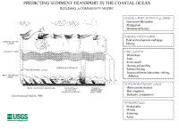
The time-series observations in this database were collected as part of research carried out by USGS investigators and collaborators to describe and advance understanding of waves, circulation and sediment transport on U.S. continental margins. Almost all of the sediment-transport research was a component of multidisciplinary studies that included geologic mapping and other measurements designed to enhance the understanding the geologic and oceanographic system of interest. A long-term goal of the program is to develop a predictive capability for the transport and fate of sediments. The transport and fate of particles shape the present-day geology, but also influence a wide range of important problems, such as the fate of contaminants, which can adhere to particles, and the fate and transport of biological particles. Beginning in 2002, a key focus of sediment-transport research at USGS is to develop, test, and evaluate coupled circulation, wave, and sediment-transport models. Figure 2 is a schematic diagram of the processes of interest that are incorporated into the modeling effort.
Many of the field experiments were carried out in collaboration with USGS field centers, Federal and state agencies, and researchers at academic institutions. For example, much of the work in the 1970s and 1980s was undertaken in cooperation with the U.S. Minerals Management Service as part of the Offshore Studies Program which was designed to investigate the environmental effects of offshore petroleum exploration. The long-term measurement program in Massachusetts Bay that was conducted from 1990 to 2006 was accomplished in collaboration with the Massachusetts Water Resources Authority as a component of the Outfall Monitoring Plan. Some of the measurements offshore of Los Angeles, California were carried out in cooperation with the U.S. Environmental Protection Agency and the Orange County Sanitation District.
A common theme of these field investigations has been to identify the oceanographic transport mechanism(s) that influence the observed pattern of bottom sediments on a regional scale. In the regions studied, these transport mechanisms often involve a strong, oscillatory high-frequency current (such as surface waves, internal waves, or tides) that causes resuspension of bottom sediments, coupled with a weaker, unidirectional residual flow (at seasonal or storm time scales) that transports sediments along or across the shelf. Field experiments typically involved deployment of arrays of instruments for periods of one to six months. Some arrays were redeployed several times at the same locations to obtain long-time-series measurements that document the seasonal and inter-annual flow variability and infrequent events. Instruments were deployed on bottom-mounted tripods, and on subsurface and surface moorings. Some of the experiments were designed for long-term monitoring of processes and events, whereas others were designed for detailed studies of bottom-boundary-layer processes.
Most of the measurements were made to address a societal issue, such as contaminated sediments or coastal erosion or fate of organisms, in addition to the fundamental questions of sediment transport. For example, observations on Georges Bank, in the Middle Atlantic Bight, and in the Santa Barbara Basin were collected to investigate the environmental effects off offshore petroleum exploration. Observations along the East Coast continental margin offshore of New York, in Massachusetts Bay, in the Hudson Shelf Valley, and on the Palos Verdes Shelf were made to study the transport and fate of contaminated sediments. Observations in the western Gulf of Maine addressed the transport and fate of toxic dinoflagellates. Observations offshore of South Carolina enabled better understanding of the transport of sand and effects on coastal erosion. Observations in the Adriatic Sea provided a description of sediment transport in a large oceanographic system with sediment input from rivers. Observations from all these regional systems provide the opportunity to apply and evaluate the numerical coupled circulation, wave, and sediment transport models. See the links in the database for brief descriptions of these and other experiments.
| Click on figures for larger images.

Figure 2. Schematic diagram showing some of the physical processes in the surface mixed layer, the bottom boundary layer and the sediment bed that are components of a sediment-transport model. |
|