U.S. Geological Survey Open-File Report 2008-1206
Coastal Change Along the Shore of Northeastern South Carolina: The South Carolina Coastal Erosion Study
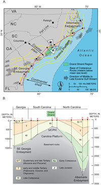
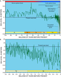
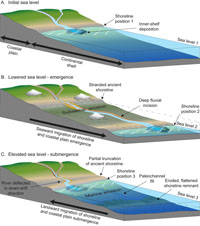
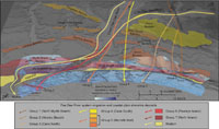
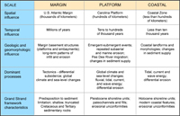
3.3 Evolution of the Geologic FrameworkThe geologic framework underlying the Grand Strand has evolved over millions of years of Earth history, and it continues to influence the development of the region’s modern coastal system. The present study has revealed three basic elements of the framework that highlight the most important aspects of Grand Strand evolution. First, numerous unconformities and extensively eroded geologic units indicate that periods of non deposition and erosion have been frequent and prolonged. Second, networks of ancient shorelines and deeply-incised paleochannels reveal linkages between cyclical sea-level change, fluvial-system evolution, and changes in sediment supply. Third, narrow and irregularly distributed modern shoreline and inner-shelf deposits suggest that sediment supply has been particularly limited during the Holocene. The evolution of the Grand Strand region is viewed in the broad context of continental-margin development, climate-driven changes in sea level, and oceanographic and fluvial processes acting along the northeastern South Carolina coast. This perspective emphasizes how broad-scale changes in the framework have influenced processes that act over increasingly small, more local scales. The general scales of influence over Grand Strand geologic evolution (Table 3.2) are designated in this report as margin, platform, and coastal, based on their geographic extent and the time periods over which they occurred. Margin Scale Margin-scale influences (1000-km and 1,000,000-yr scales) are related to the position of the Grand Strand region within the wider geologic framework of the U.S. Atlantic continental margin (Table 3.2). The following description of margin evolution is based on studies by Owens and Gohn (1985), Popenoe (1985, 1990), Klitgord and others (1988), Riggs and Belknap (1988), and Gohn (1988). About 210 million years ago the continents of North America and Africa began to pull apart, or rift, creating a narrow seaway that eventually widened to become the North Atlantic Ocean. During rifting, the continental crust that formed the margin was faulted into a series of coherent blocks. While the ocean basin widened, the crustal blocks deformed and differentially subsided as they cooled and were buried by massive amounts of sediment. These tectonic adjustments warped the basement rocks into a series of structural highs and lows. The highs, called platforms and arches, formed where the crust subsided least. The lows, called embayments, basins, and troughs, formed where it subsided most. Northeastern South Carolina overlies a prominent structural high called the Carolina Platform (Figure 3.6). Interactions between this structure, global sea level, and oceanographic currents have strongly influenced patterns of deposition and erosion since the Late Jurassic (about 150 million years ago, Table 3.1). Sediment deposits reach up to 3 km (2 mi) thick within the adjacent Albemarle and Southeast Georgia Embayments, but thin to less than 500 m (1,640 ft) across the shallowest, most stable portion of the Carolina Platform, which is called the Cape Fear Arch or Mid-Carolina Platform High (MCPH). The Grand Strand region was predisposed to long-term sediment limitation early during margin development because of its location near the apex of the MCPH. The region was a depositional center during the Late Cretaceous and early Tertiary, when global climate was warm and sea levels were generally much higher than present (Figure 3.7a). Thick sediments accumulated across calm continental shelves, roughly paralleling the topography of the underlying structure (Figure 3.6b). Nondeposition and erosion became dominant during the Middle to Late Eocene (between about 50 and 34 million years ago, Table 3.1), when an ancient equivalent of the Gulf Stream current temporarily flowed across the MCPH (Figure 3.6a). The current prevented deposition, removed earlier Eocene deposits, and truncated early Tertiary and Late Cretaceous units. Cooler global climate and formation of polar ice sheets generally lowered sea level throughout the remainder of the Tertiary Period (Figure 3.7a). As sea level fell, sediment mostly continued to accumulate across the relatively low-relief embayments and areas farther seaward, while minimal deposition and erosion prevailed across the MCPH. The shallow burial and truncation of sedimentary rocks that form the foundation of the Grand Strand resulted from the unique history of structural development, deposition, and erosion along this portion of the margin. The slight downward tilt, or dip, of the rock layers away from the apex of the MCPH reflects how their deposition generally conformed to the underlying structural trend (Figures 3.4 and 3.6b). The rocks are rather erosion-resistant, but cementation differs from layer to layer. Truncation has exposed the dipping layers as parallel units across the surface of the foundation. This causes erosional resistance to differ slightly over the width of the rocky foundation because weakly cemented units are more susceptible to erosion than adjacent, well cemented units. Platform Scale Platform-scale changes (100-km and 10,000–100,000-yr scales) have occurred as fluctuations in sea level forced shoreline migrations back and forth across the Carolina Platform (Table 3.2). Since the Late Pliocene (about 3 million years ago), changes in the volume of Arctic polar ice sheets have caused sea level to repeatedly rise and fall as much as 25 m (83 ft) above and 120 m (396 ft) below its present elevation (Figure 3.7; Box #1). During times of lower sea level, the exposed coastal plain and continental shelf underwent broad subaerial erosion and deep fluvial incision while shoreline deposits accumulated at lower elevations seaward of the modern coast (Figure 3.8). When rising sea level submerged the coastal plain and forced the shoreline to migrate landward, relatively brief periods of shoreline development occurred at higher elevations. As the shoreline migrated back and forth, wave and current energy continually eroded coastal landforms, redistributed sediment, and generally flattened the landscape. The history of these emergent and submergent events is partially preserved across the coastal plain in a series of remnant shoreline deposits (Figure 1.6; Colquhoun and others, 1991; Colquhoun, 1995). The ancient shorelines were deposited during submergences that reached progressively lower elevations over time; they decrease in age and elevation toward the modern coast. Coastal deposits across northeastern South Carolina are primarily composed of sediment supplied by the Pee Dee River, which has transported large volumes of material eroded from the Blue Ridge Mountains, Piedmont, and coastal plain to the coast (Brown, 1980; Meade, 1982; Hayes, 1994). Seven groups of large paleochannels underlying the Grand Strand record a regional southwestward migration of the Pee Dee River between the Late Pliocene and present (Figure 3.5a and 3.9; Putney and others, 2004; Baldwin and others, 2006). The migration was primarily driven by the formation of Pleistocene shorelines during periods of higher-than-present sea level. These ridge-like, elongate landforms were deposited across the lower coastal plain over successive submergences, and their orientations rotated from generally east-west to northeast-southwest trends. Each newly formed shoreline deflected the river to the southwest and forced it to carve a new course during the subsequent period of emergence. During the most recent highstand of sea level about 120,000 years ago, deposition of the Myrtle Beach Barrier caused extreme deflection of the river and eventually forced it to flow parallel to the shoreline (Figure 3.9). This deflection caused the river mouth to move from the central part of the Grand Strand near Murrells Inlet to its southernmost extent at Winyah Bay and thus significantly reduced the role of the Pee Dee River as a source of regional sediment supply. During the Holocene, sediment transported by the river has contributed minimally to shoreline development along the Grand Strand because most of it has been deposited within Winyah Bay (Hayes, 1994; Patchineelam and others, 1999). Beach sediment is now primarily supplied through erosion of older geologic units along the coast and inner shelf. This sediment mainly accumulates in southern parts of the region due to predominantly southwestward sediment transport within Long Bay. Over the past 3 million years, platform-scale changes have profoundly influenced Grand Strand evolution. Fluvial systems that incised the network of paleochannels into the sedimentary-rock foundation caused localized topographic variation across the foundation’s otherwise low-relief surface beneath the coast and inner shelf (Figure 3.5a). Differential erosion across the foundation clearly influenced the spatial patterns of this fluvial incision, as Tertiary units south of Surfside Beach are more extensively incised than the more resistant Cretaceous units to the north (Figure 3.2). Additionally, the potential for differential erosion increased as more erodible channel-fill deposits were embedded across the width of the rocky foundation. Alternating periods of subaerial and marine erosion caused continual excavation and gradually deepened the regional unconformity that defines the upper surfaces of channel-fill deposits and sedimentary rocks (Figure 3.2). Although this long-term erosion tended to flatten the landscape, some subtle topography remains across the unconformity. It is notable that younger channel fills south of Murrells Inlet are less flattened than older features to the north because they have undergone fewer periods of emergence and submergence. Except for channel-fill deposition, the Grand Strand mostly underwent erosion or non deposition until about 400,000 years ago. Since that time, successive submergences culminated at elevations near the present shoreline, and resulted in the consecutive deposition and partial erosion of Pleistocene shoreline units that compose the coastal upland and Holocene shoreline units that form the modern coast (Figures 3.2 and 3.9). Over this time period, platform-scale influences overlapped with smaller, coastal-scale influences and caused the Late Pleistocene shift in the dominant mode of regional sediment supply. The shift from a high-volume fluvial source supplied by the Pee Dee River to a lower-volume erosional source supplied by coastal and inner-shelf erosion has strongly influenced subsequent coastal-scale changes, which have determined the distribution, configuration, and preservation of shoreline units along the Grand Strand. Coastal Scale Coastal-scale changes (less than 100-km and less than 10,000-yr scales) occur as rivers and streams, winds, waves, and currents expend energy across the coastal upland, beach, and nearshore-marine zone (Table 3.2). These processes create and modify coastal features such as barrier islands, spits, tidal inlets, marshes, and mud flats, as well as sand ridges and shoals on the inner shelf. Significant coastal deposition has occurred across northeastern South Carolina only when sea level has been relatively high, like today, and slowly rising or falling. During these periods of relative stability, the development of coastal features is determined by interaction between nearshore processes (wave and current energy), sediment supply, and preexisting geologic framework. Progressive southwestward deposition along the shorelines of northeastern South Carolina suggests a consistent, long-term pattern of domination by wave-driven currents and the resulting alongshore transport of sediment. This pattern has apparently remained constant over periods of submergence since the Pleistocene. Growth of the North Island spit across the mouth of Winyah Bay (Figure 3.9) and the concentration of inner-shelf sediment across the southern portion of the region (Figure 3.5b) show that these southerly directed, sediment transport processes continue to dominate today. Like older Pleistocene shorelines across the lower coastal plain (Figure 1.6), the late Pleistocene Myrtle Beach Barrier is expansive compared to the Holocene shoreline units that line the modern coast (Figure 3.9). The Myrtle Beach Barrier formed while sediment transported by the Pee Dee River was still delivered to the central portion of the coast; however, sediment supply decreased after the mouth of the Pee Dee River migrated south in the late Pleistocene away from the center of Long Bay. The river now discharges into Winyah Bay, and little or no sediment reaches Grand Strand beaches. As a result, the modern coastal system is sand-limited with thin layers of Holocene shoreline and inner-shelf sediment perched on top of older geologic units. During the ongoing landward migration of the coast, the old shoreline deposits that lie behind the modern beach have been significantly eroded north of Surfside Beach. Predominant southwestward alongshore transport has generally prevented sediment deposition along this portion of the coast, and only thin Holocene beaches have developed. In contrast, the Myrtle Beach Barrier is well preserved south of Surfside Beach, where it has been protected by modern barrier islands and spits. The conditions and extents of shoreline units along the Grand Strand coast clearly illustrate the dominant effects of wave and current energy after the Late Pleistocene shift in sediment supply (Figures 3.2 and 3.9). Large, well developed shorelines formed during periods of relatively high sea level when abundant sediment was delivered to Long Bay by the ancestral Pee Dee River. As each successive shoreline formed, topographic relief on the lower coastal plain increased, and thereby enhanced the difference in slope between the coastal plain and the adjacent, flat-lying inner shelf. Alongshore topographic variability has influenced the shapes of successive shorelines. Waves and currents have differentially eroded the old shorelines and redistributed sediment across lower lying areas. Shoreline erosion has preferentially occurred adjacent to locations where paleochannel fills are embedded into the underlying sedimentary rock-foundation, and this erosional pattern has regionally controlled coastal drainage patterns (Figure 3.2). Salt-marsh creeks and coastal swashes occupy these depressions, draining runoff from higher areas of the coastal upland, and tidal inlets allow for vigorous exchange of tidally driven flow between the depressions and the coastal ocean. The largest accumulations of Holocene inner-shelf sediments also overlie embedded paleochannel fills due to a combination of inner-shelf erosion and the tendency of adjacent tidal inlets to concentrate sediment. Next Section: 3.4 Summary » |

 U.S. Department of the Interior |
U.S. Geological Survey
U.S. Department of the Interior |
U.S. Geological Survey
URL: https://pubsdata.usgs.gov/pubs/of/2008/1206/html/framework2.html
Page Contact Information: Publishing Service Center
Page Last Modified: Monday, 03-Jun-2019 11:36:38 EDT