USGS - science for a changing world

FISC - St. Petersburg

Coastal & Marine Geology Program > Center for Coastal & Watershed Studies > Professional Paper 1751

Systematic Mapping of Bedrock and Habitats along the Florida Reef Tract—Central Key Largo to Halfmoon Shoal (Gulf of Mexico)

USGS Professional Paper 1751

by Barbara H. Lidz, Christopher D. Reich, and Eugene A. Shinn

Introduction:
Table of Contents
Project Overview
Project Objective
Geologic Setting
Primary Datasets
Primary Products - Overview Maps & Evolution Overview:
Bedrock Surface map.
Introduction
Depth to Pleistocene Bedrock Surface
Reef & Sediment Thickness
Benthic Ecosystems & Environments
Sedimentary Grains in 1989
Summary Illustration Index Map
Evolution Overview
Tile-by-Tile Analysis
Satellite image of the Florida Keys showing location of tiles.
Organization of Report
Tiles: 1, 2, 3, 4,
5, 6, 7/8, 9/10,
11
Summary
Acknowledg-
ments
References
Disclaimer
Related
Publications

Primary Products

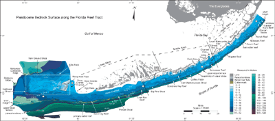
Overview Map—Depth to Pleistocene Bedrock Surface: Coral reefs and sediments (now cemented limestone bedrock) accumulated over many thousands of years. Their resultant buildups contain records of past environmental quality and physical/biological processes. In Florida, ancient reefs form much of the bedrock (e.g., Sanford, 1909; Hoffmeister and Multer, 1964; Perkins, 1977). The bedrock is Pleistocene (Fig. 7B).

Detailed regional bedrock topography in the Florida Keys was derived from geophysical data that provided the depth of the bedrock surface below present sea level. High-resolution seismic-reflection profiles were generated using acoustic (sound-wave) instruments. Water, sediments, and rock have different acoustical properties and produce different lines on a seismic profile. The sound waves penetrate through the water column and sediments, reflecting the sediment (seafloor) surface and the contact between the sediments and underlying bedrock. The sediment thickness can be calculated and the topography of the bedrock surface can be determined and contoured from the profiles (see Bedrock Surface map and Open-File Report 00-046. The lines representing these surfaces on the profiles are known as seismic reflections.

Bedrock Surface map: Updated map of the bedrock surface shows contours of regional Pleistocene topography from the northern Florida Keys to west of The Quicksands.
Bedrock Surface map: Updated map of the bedrock surface shows contours of regional Pleistocene topography from the northern Florida Keys to west of The Quicksands. (From Lidz et al., 2003). The contours were derived from USGS geophysical data combined with selected analogous data of Enos (1977; see Data Integration section). Structure contours and numbers on colors are in meters below present sea level. Dogleg and diagonal lines divide upper, middle, and lower Keys.

Colors represent different bedrock elevations ranging from highest (pale blues) to lower (darker blues) to lowest (shades of darkest blues and greens). Outlier reefs (Lidz et al., 1991) are in shades of brown (light = high relief, dark = low relief or buried). The map scale is too small to show all four tracts of outlier reefs that occur off Rock Key and Sand Key Reefs, located at the shelf edge southwest of Key West. The shelf-margin fossil reef coincides with the dark blue line just landward of the outlier reefs. Note the elevated ridge (in large white rectangle) on which the Marquesas Keys are located. The most extensive areas of pale colors (i.e., shallowest depths mapped) are around the Marquesas Keys and along the inner shelf of the middle and upper Keys. Also note the generally margin-parallel nature of bedrock trends seaward of the keys.

Contacts between colors can be interpreted to represent positions and shapes of Holocene shorelines as sea level rose. Shelf-wide, bedrock elevations are several meters lower to the southwest than northeast, indicating the shelf flooded from southwest to northeast. Flooding direction is confirmed by radioisotope dates on Holocene corals. Circled numbers denote sequential 'stages' in which various areas of the shelf flooded: 1 at 18 m below present sea level; 2 at 14 m; 3 at 10 m; 4 at 6 m; 5 at 4 m; and 6 at 2 m. (Modified from Lidz et al., 2003). [larger version]

Although discontinuous, bedrock coral reefs are hundreds of meters wide, tens of meters high, and more than 200 km in extent. Such dimensions indicate that conditions during the various periods of their accumulation were highly favorable for coral growth region-wide (see Seven Coral Reef Ecosystems section).

Mapping surface contours of the pre-existing rock surface is the first step toward reconstruction of the geologic history and processes at work along the Florida reef tract. The bedrock surface shows:

  • how the shelf flooded during the most recent rise in sea level (from southwest to northeast),
  • where sediment accumulated (in depressions), and
  • where corals grew (on elevated, sediment-free surfaces).

Supplemental information is obtained by coring the bedrock. Cores recover datable material (soilstone crusts that formed when the shelf was exposed, mangrove peat that formed at offshore shorelines as the shelf flooded, and corals that changed species in a reef or that grew landward with rising sea level). Most importantly, radioisotope dates on bedrock corals indicate the different times when the shelf was flooded in the past (i.e., times of high sea levels). Dates on soilstone crusts now submerged similarly indicate times when the shelf was exposed by lowered sea levels.

The Florida peninsula is regarded as having been tectonically stable during the Pleistocene (Fig. 7B; e.g., Davis et al., 1992; Ludwig et al., 1996; Toscano and Lundberg, 1999). When viewing the bedrock map, envision the sea rising over an uneven rock floor. The map shows that elevations are several meters lower to the southwest than northeast; thus, bedrock flooded earlier in the southwest. Dates on overlying Holocene corals confirm earlier flooding to the southwest (see Summary Illustration index map).

Coastal & Marine Geology Program > Center for Coastal & Watershed Studies > Professional Paper 1751

Accessibility FOIA Privacy Policies and Notices

Take Pride in America logo USA.gov logo U.S. Department of the Interior | U.S. Geological Survey
URL: [disc] /pubs/pp/2007/1751/professional-paper/bedrock-surface.html
Page Contact Information: Feedback
Page Last Modified: December 01, 2016 @ 04:11 PM (JSS)