USGS - science for a changing world

FISC - St. Petersburg
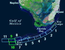
Coastal & Marine Geology Program > Center for Coastal & Watershed Studies > Professional Paper 1751

Systematic Mapping of Bedrock and Habitats along the Florida Reef Tract—Central Key Largo to Halfmoon Shoal (Gulf of Mexico)

USGS Professional Paper 1751

by Barbara H. Lidz, Christopher D. Reich, and Eugene A. Shinn

Introduction:
Table of Contents
Project Overview
Project Objective
Geologic Setting
Primary Datasets
Primary Products - Overview Maps & Evolution Overview:
Bedrock Surface map.
Introduction
Depth to Pleistocene Bedrock Surface
Reef & Sediment Thickness
Benthic Ecosystems & Environments
Sedimentary Grains in 1989
Summary Illustration Index Map
Evolution Overview
Tile-by-Tile Analysis
Satellite image of the Florida Keys showing location of tiles.
Organization of Report
Tiles: 1, 2, 3, 4,
5, 6, 7/8, 9/10,
11
Summary
Acknowledg-
ments
References
Disclaimer
Related
Publications

Tile 9/10

The submerged part of the Florida shelf extends westward beyond the Florida Keys into the Gulf of Mexico. Islands of the Dry Tortugas mark its westernmost land (Fig. 6A, 6B). The shelf continues another 113 km west of the Tortugas before dropping off into the Gulf.

Tile 9 coordinates:
24°38'16.08" N. 82°13'18.12" W.
24°38'16.08" N. 81°57'00.00" W.
24°31'01.92" N. 81°57'00.00" W.
24°31'01.92" N. 82°13'18.12" W.
Tile 10 coordinates:
24°31'01.92" N. 82°11'53.88" W.
24°31'01.92" N. 81°55'32.88" W.
24°23'34.08" N. 81°55'32.88" W.
24°23'34.08" N. 82°11'53.88" W.

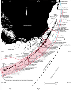
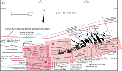
Major Geographic Sites: The inner-shelf area of the Tile 9/10 sector (Gulf of Mexico) includes Boca Grande Key, Boca Grande Channel, and the Marquesas Keys. Cosgrove Shoal and Coalbin Rock rim the outer-shelf margin south of those sites (Fig. 115A, 115C; 115B shows the middle and upper Keys).

Boca Grande Key, Boca Grande Channel, and the Marquesas Keys lie within the Key West National Wildlife Refuge, along with smaller islands between Boca Grande Key and Key West (Fig. 97C). Around 1960 when the oil-and-gas industry began to ramp up exploratory drilling in the Gulf of Mexico, the Marquesas Keys was one of the areas of interest.

Figure 115. (A) Landsat satellite image of south Florida shows individual tile boundaries (blue rectangles) of this regional study in the Florida Keys National Marine Sanctuary. Tile 9/10 is highlighted. (B) Index map shows locations of named reefs and shoals in the upper Keys and northeastern middle Keys, delineated by dashed lines. Red rectangles show geographic boundaries of Tiles 1, 2, 3, and 4. (C) Contiguous southwestern part of index map shows reefs and shoals in the westernmost middle Keys and lower Keys (dashed lines). Red rectangles show geographic boundaries of Tiles 5, 6, 7, 8, 9, and 10, with Tile 9/10 (here considered a single tile) and its geographic sites highlighted. Black-dot rectangle shows area of Key West National Wildlife Refuge. Sanctuary boundary is in red; shelf-margin contour is in blue. Contours are in meters. [larger version]
Landsat satellite image of south Florida shows individual tile boundaries (blue rectangles) of this regional study in the Florida Keys National Marine Sanctuary. Tile 9/10 is highlighted.
Index map shows locations of named reefs and shoals in the upper Keys and northeastern middle Keys
Contiguous southwestern part of index map shows reefs and shoals in the westernmost middle Keys and lower Keys

Coastal & Marine Geology Program > Center for Coastal & Watershed Studies > Professional Paper 1751

Accessibility FOIA Privacy Policies and Notices

Take Pride in America logo USA.gov logo U.S. Department of the Interior | U.S. Geological Survey
URL: [disc] /pubs/pp/2007/1751/professional-paper/tile9-10/tile9-10.html
Page Contact Information: Feedback
Page Last Modified: December 01, 2016 @ 04:15 PM (JSS)